Category:Rijnstraat 41, Arnhem
Jump to navigation
Jump to search
| Object location | | View all coordinates using: OpenStreetMap |
|---|
building in Arnhem, Netherlands  | |||||
| Upload media | |||||
| Instance of | |||||
|---|---|---|---|---|---|
| Location | Arnhem, Gelderland, Netherlands | ||||
| Street address |
| ||||
| Heritage designation |
| ||||
 | |||||
|
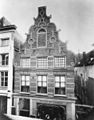
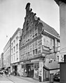
This is a category about rijksmonument number 8359
|
| Address |
|
Media in category "Rijnstraat 41, Arnhem"
The following 6 files are in this category, out of 6 total.
-
 Bovendeel voorgevel - Arnhem - 20025553 - RCE.jpg 1,200 × 1,197; 330 KB
-
 De-Moriaan.JPG 2,304 × 3,072; 1.7 MB
-
 Huis - Arnhem - 20025549 - RCE.jpg 943 × 1,200; 245 KB
-
-
 Overzicht voorgevel huis - Arnhem - 20321202 - RCE.jpg 911 × 1,200; 159 KB
-
 Voorgevel - Arnhem - 20025554 - RCE.jpg 958 × 1,200; 146 KB


