Category:Roads in Plymouth Township, Montgomery County, Pennsylvania
Jump to navigation
Jump to search
Media in category "Roads in Plymouth Township, Montgomery County, Pennsylvania"
The following 79 files are in this category, out of 79 total.
-

-

-

-

-

-

-

-

-

-

-

-

-

-

-
-

-

-

-

-
-

-
-

-

-

-

-

-

-

-

-

-

-

-
 Butler Pike NB at Cold Point Hill.jpg 1,764 × 1,305; 664 KB
-
 Butler Pike NB at PA Turnpike.jpg 1,851 × 1,389; 655 KB
-
 Butler Pike NB at Plymouth-Flourtown Rd.JPG 2,592 × 1,944; 800 KB
-
 Butler Pike NB at Trenton Cutoff.jpg 1,782 × 1,371; 773 KB
-
 Butler Pike SB at Township Line Rd.jpg 1,788 × 1,287; 577 KB
-
 Exit 20.JPG 1,024 × 769; 70 KB
-
 Germantown Pike WB past Plymouth Road.jpeg 4,032 × 3,024; 3.4 MB
-
 I-276 West - Exit 333 - Norristown (43704826762).jpg 2,400 × 1,600; 1.59 MB
-
 I-476 Bridge.jpg 3,024 × 4,032; 3.32 MB
-
 I-476 NB 0.25 mile to Ridge Pike.JPG 3,072 × 2,304; 505 KB
-
 I-476 NB 1 mile to Ridge Pike.JPG 3,072 × 2,304; 474 KB
-
 I-476 NB 2 miles to PA TPK.JPG 848 × 579; 37 KB
-
 I-476 NB at Ridge Pike EB exit.JPG 845 × 577; 47 KB
-
 I-476 NB at Ridge Pike WB exit.JPG 3,072 × 2,304; 464 KB
-
 I-476 NB on Pearl Harbor Memorial Bridge.JPG 851 × 581; 30 KB
-
 I-476 SB 1 mi to Ridge Pike.JPG 3,072 × 2,304; 435 KB
-
 I-476 SB 1000 feet to toll plaza.JPG 3,072 × 2,304; 464 KB
-
 I-476 SB 2 mi to I-76.JPG 851 × 581; 36 KB
-
 I-476 SB approaching Pearl Harbor Memorial Bridge.JPG 841 × 574; 36 KB
-
 I-476 SB at Ridge Pike exit.JPG 841 × 574; 34 KB
-
 I-476 SB on Pearl Harbor Memorial Bridge.JPG 844 × 576; 26 KB
-
 I-476 SB PA 23 sign.JPG 3,072 × 2,304; 395 KB
-
 I-476 signs on Ridge Pike.JPG 3,072 × 2,304; 2.72 MB
-
 Int276wRoad-Int476nsExitRampSigns (32776221254).jpg 2,400 × 1,600; 2.01 MB
-
 MCPC photos DSC 0012 (32833402573).jpg 6,016 × 4,000; 6.28 MB
-
 Mid-County toll plaza SB.JPG 3,072 × 2,304; 461 KB
-
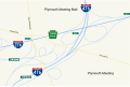 MidCounty interchange map.svg 806 × 538; 196 KB
-
 Norristown ramps to PA TPK.JPG 848 × 579; 39 KB
-
 NorristownExit.jpg 3,264 × 2,448; 1.86 MB
-
 PA TPK EB approaching Mid-County.JPG 3,072 × 2,304; 408 KB
-
 PA TPK EB at Mid-County 2.JPG 3,072 × 2,304; 422 KB
-
 PA TPK EB at Mid-County.JPG 3,072 × 2,304; 479 KB
-
 PA TPK EB past Mid-County.JPG 3,072 × 2,304; 464 KB
-
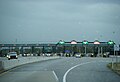 PA TPK Norristown tollbooth.JPG 846 × 578; 34 KB
-
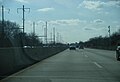
 PA TPK WB 0.5 mi to Norristown.JPG 843 × 576; 42 KB
-
 PA TPK WB across Schuylkill River.JPG 842 × 575; 35 KB
-
 PA TPK WB approaching Norristown.JPG 3,072 × 2,304; 454 KB
-
 PA TPK WB approaching Schuylkill River.JPG 847 × 578; 43 KB
-
 PA TPK WB at Mid-County.JPG 841 × 574; 43 KB
-
 PA TPK WB at Norristown.JPG 3,072 × 2,304; 443 KB
-
 PA TPK WB past Norristown.JPG 3,072 × 2,304; 457 KB
-
 Pearl Harbor Memorial Bridge.jpg 3,024 × 4,032; 3.14 MB
-
 Ridge Pike WB past Butler Pike.jpeg 4,032 × 3,024; 3.79 MB
-
 Schuylkill River Bridge.jpg 3,264 × 2,448; 1.56 MB
-
 WB Mid-County ramp 0.5 mi to toll plaza.JPG 847 × 579; 36 KB
-
 WB Mid-County ramp split.JPG 841 × 574; 37 KB
_at_the_exit_for_Interstate_476_(Allentown,_Chester)_in_Plymouth_Township,_Montgomery_County,_Pennsylvania.jpg)
_at_Exit_333_(Norristown)_in_Plymouth_Township,_Montgomery_County,_Pennsylvania.jpg)
_just_west_of_Exit_333_in_Plymouth_Township,_Montgomery_County,_Pennsylvania.jpg)
_at_Exit_18A_(Conshohocken)_in_Plymouth_Township,_Montgomery_County,_Pennsylvania.jpg)
_at_Exit_18B_(Norristown)_in_Plymouth_Township,_Montgomery_County,_Pennsylvania.jpg)
_just_north_of_Exit_18B_in_Plymouth_Township,_Montgomery_County,_Pennsylvania.jpg)
_at_Exit_19_(Plymouth_Meeting)_in_Plymouth_Township,_Montgomery_County,_Pennsylvania.jpg)
_at_Exit_20_(Interstate_276_WEST,_Harrisburg,_Plymouth_Road)_in_Plymouth_Township,_Montgomery_County,_Pennsylvania.jpg)
_at_the_exit_for_Interstate_276_EAST_(New_Jersey)_in_Plymouth_Township,_Montgomery_County,_Pennsylvania.jpg)
_just_north_of_Interstate_276_(Pennsylvania_Turnpike_Delaware_River_Extension)_in_Plymouth_Township,_Montgomery_County,_Pennsylvania.jpg)
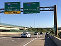
_at_Exit_333_(Interstate_476_SOUTH,_Chester)_in_Plymouth_Township,_Montgomery_County,_Pennsylvania.jpg)
_at_the_exit_for_Interstate_476_NORTH_(Northeast_Extension,_Allentown)_in_Plymouth_Township,_Montgomery_County,_Pennsylvania.jpg)
_just_north_of_Interstate_276_(Pennsylvania_Turnpike_Delaware_River_Extension)_in_Plymouth_Township,_Montgomery_County,_Pennsylvania.jpg)
_at_the_exit_for_Interstate_276_WEST_(Harrisburg)_in_Plymouth_Township,_Montgomery_County,_Pennsylvania.jpg)
_at_the_exit_for_Interstate_276_EAST_(New_Jersey)_in_Plymouth_Township,_Montgomery_County,_Pennsylvania.jpg)
_between_Interstate_276_(Pennsylvania_Turnpike_Delaware_River_Extension)_and_Exit_18_in_Plymouth_Township,_Montgomery_County,_Pennsylvania.jpg)
_at_Exit_18_(Norristown)_in_Plymouth_Township,_Montgomery_County,_Pennsylvania.jpg)
_from_the_overpass_for_Ridge_Pike_in_Plymouth_Township,_Montgomery_County,_Pennsylvania.jpg)
_from_the_overpass_for_Ridge_Pike_in_Plymouth_Township,_Montgomery_County,_Pennsylvania.jpg)
_from_the_overpass_for_Ridge_Pike_in_Plymouth_Township,_Montgomery_County,_Pennsylvania.jpg)
_from_the_overpass_for_Ridge_Pike_in_Plymouth_Township,_Montgomery_County,_Pennsylvania.jpg)
_from_the_overpass_for_Belvoir_Road_in_Plymouth_Township,_Montgomery_County,_Pennsylvania.jpg)
_from_the_overpass_for_Belvoir_Road_in_Plymouth_Township,_Montgomery_County,_Pennsylvania.jpg)
_from_the_overpass_for_the_ramps_to_Germantown_Pike_in_Plymouth_Township,_Montgomery_County,_Pennsylvania.jpg)
_from_the_overpass_for_the_ramps_to_Germantown_Pike_in_Plymouth_Township,_Montgomery_County,_Pennsylvania.jpg)
_from_the_overpass_for_Germantown_Pike_in_Plymouth_Township,_Montgomery_County,_Pennsylvania.jpg)
_from_the_overpass_for_Germantown_Pike_in_Plymouth_Township,_Montgomery_County,_Pennsylvania.jpg)
_from_the_overpass_for_Plymouth_Road_in_Plymouth_Township,_Montgomery_County,_Pennsylvania.jpg)
_from_the_overpass_for_Plymouth_Road_in_Plymouth_Township,_Montgomery_County,_Pennsylvania.jpg)
_from_the_overpass_for_Interstate_476_(Pennsylvania_Turnpike_Northeast_Extension)_in_Plymouth_Township,_Montgomery_County,_Pennsylvania.jpg)
_from_the_overpass_for_Interstate_476_(Pennsylvania_Turnpike_Northeast_Extension)_in_Plymouth_Township,_Montgomery_County,_Pennsylvania.jpg)
_from_the_overpass_for_Walton_Road_in_Plymouth_Township,_Montgomery_County,_Pennsylvania.jpg)
_from_the_overpass_for_Walton_Road_in_Plymouth_Township,_Montgomery_County,_Pennsylvania.jpg)


.jpg)


.jpg)
.jpg)


