Category:Rockport, Massachusetts in the 1890s
Jump to navigation
Jump to search
|
Media in category "Rockport, Massachusetts in the 1890s"
The following 16 files are in this category, out of 16 total.
-

-
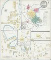 Sanborn Fire Insurance Map from Rockport, Essex County, Massachusetts. LOC sanborn03833 002-1.tif 6,450 × 7,650; 141.17 MB
-

-
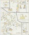
 Sanborn Fire Insurance Map from Rockport, Essex County, Massachusetts. LOC sanborn03833 002-2.tif 6,450 × 7,650; 141.17 MB
-

-
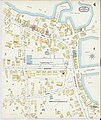
 Sanborn Fire Insurance Map from Rockport, Essex County, Massachusetts. LOC sanborn03833 002-3.tif 6,450 × 7,650; 141.17 MB
-

-
 Sanborn Fire Insurance Map from Rockport, Essex County, Massachusetts. LOC sanborn03833 002-4.tif 6,450 × 7,650; 141.17 MB
-

-
 Sanborn Fire Insurance Map from Rockport, Essex County, Massachusetts. LOC sanborn03833 003-1.tif 6,450 × 7,650; 141.17 MB
-

-
 Sanborn Fire Insurance Map from Rockport, Essex County, Massachusetts. LOC sanborn03833 003-2.tif 6,450 × 7,650; 141.17 MB
-

-
 Sanborn Fire Insurance Map from Rockport, Essex County, Massachusetts. LOC sanborn03833 003-3.tif 6,450 × 7,650; 141.17 MB
-
-
 Sanborn Fire Insurance Map from Rockport, Essex County, Massachusetts. LOC sanborn03833 003-4.tif 6,450 × 7,650; 141.17 MB


