Category:Roman catholic parish church with cemetery wall (Eggenwil)
Jump to navigation
Jump to search
| Object location | | View all coordinates using: OpenStreetMap |
|---|
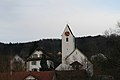
church building in Eggenwil in the canton of Aargau, Switzerland  | |||||
| Upload media | |||||
| Instance of | |||||
|---|---|---|---|---|---|
| Part of | |||||
| Location | Eggenwil, Bremgarten District, Aargau, Switzerland | ||||
| Street address |
| ||||
| Heritage designation | |||||
 | |||||
Media in category "Roman catholic parish church with cemetery wall (Eggenwil)"
The following 6 files are in this category, out of 6 total.
-
 Eggenwil Kirche 2014-01-09 01.jpg 3,888 × 2,592; 2.71 MB
-
 Eggenwil Kirche 2014-01-09 02.jpg 2,592 × 3,888; 2.61 MB
-
 Eggenwil Kirche 2014-01-09 03.jpg 2,592 × 3,888; 2.8 MB
-
 Eggenwil Preghejo 155.jpg 3,872 × 2,592; 4.11 MB
-
 Eggenwil Preghejo 161.jpg 3,872 × 2,592; 4.12 MB
-
 Eggenwil vilagha rivero kaj preghejo 160.jpg 2,592 × 3,872; 4.85 MB


