Category:Rothiemay
Jump to navigation
Jump to search
Scottish parish in Moray, Scotland, UK | |||||
| Upload media | |||||
| Instance of | |||||
|---|---|---|---|---|---|
| Named after | |||||
| Location |
| ||||
| Population |
| ||||
| Area |
| ||||
 | |||||
Subcategories
This category has the following 4 subcategories, out of 4 total.
Media in category "Rothiemay"
The following 136 files are in this category, out of 136 total.
-
 Access lane to Auchinclech - geograph.org.uk - 3106975.jpg 1,379 × 1,095; 442 KB
-
 Access lane to Netherton of Knock - geograph.org.uk - 3106980.jpg 1,824 × 1,368; 697 KB
-
 Auchencrieve Cottages - geograph.org.uk - 4033391.jpg 640 × 427; 341 KB
-
 Barlatch Wood - geograph.org.uk - 2579291.jpg 3,456 × 2,304; 1.76 MB
-
 Cairn of Mayen - geograph.org.uk - 5977369.jpg 1,024 × 683; 166 KB
-
 Cairnhill - geograph.org.uk - 4033406.jpg 640 × 427; 366 KB
-
 Cairns of Mayen Farm Buildings - geograph.org.uk - 5977391.jpg 1,024 × 683; 143 KB
-
 Castle Gate - geograph.org.uk - 4033776.jpg 423 × 640; 495 KB
-
 Cattle at Woodside - geograph.org.uk - 4033398.jpg 640 × 427; 458 KB
-
 Comfrey (Symphytum sp) - geograph.org.uk - 4033430.jpg 640 × 483; 418 KB
-
 Comfrey (Symphytum sp) - geograph.org.uk - 4033728.jpg 640 × 585; 435 KB
-
 Corskellie - geograph.org.uk - 4033552.jpg 640 × 427; 472 KB
-
 Corskellie - geograph.org.uk - 4033598.jpg 640 × 318; 267 KB
-
 Cottage at Ramsburn - geograph.org.uk - 1236404.jpg 640 × 480; 101 KB
-
 Dame's Violet (Hesperus matronalis) - geograph.org.uk - 4033432.jpg 533 × 640; 362 KB
-
 Dead Trees - geograph.org.uk - 4033669.jpg 640 × 427; 453 KB
-
 Denspark and Dens of Mayen - geograph.org.uk - 4033501.jpg 640 × 427; 377 KB
-
 Deveron by Rothiemay - geograph.org.uk - 2579244.jpg 3,456 × 2,304; 1.88 MB
-
 Drain - geograph.org.uk - 4033771.jpg 427 × 640; 482 KB
-
 Eastertown of Mayen - geograph.org.uk - 4033458.jpg 640 × 427; 546 KB
-
 Eastertown of Mayen - geograph.org.uk - 4033461.jpg 640 × 427; 575 KB
-
 Eastertown of Mayen - geograph.org.uk - 4033467.jpg 640 × 427; 499 KB
-
 Electricity pylon by B9022 - geograph.org.uk - 3106968.jpg 1,368 × 1,824; 558 KB
-
 Fallen Giant - geograph.org.uk - 4033738.jpg 640 × 427; 399 KB
-
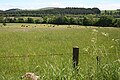
 Fields near Shielparks - geograph.org.uk - 1720985.jpg 640 × 427; 240 KB
-
 Fields near South Redhill - geograph.org.uk - 4345549.jpg 640 × 427; 388 KB
-
 Fishing Hut - geograph.org.uk - 4033682.jpg 640 × 427; 504 KB
-
 Flowering Bushes - geograph.org.uk - 4033780.jpg 640 × 427; 415 KB
-
 Forest Access - geograph.org.uk - 4033437.jpg 640 × 427; 422 KB
-
 Gallow Hill from Woodfold - geograph.org.uk - 997988.jpg 640 × 427; 237 KB
-
 Glennie Home Farm - geograph.org.uk - 4033513.jpg 640 × 427; 400 KB
-
 Haickburn Cottage - geograph.org.uk - 4033593.jpg 640 × 427; 387 KB
-
 Hill of Retanach - geograph.org.uk - 5977386.jpg 1,024 × 683; 109 KB
-
 Hill of Retenach - geograph.org.uk - 5977373.jpg 1,024 × 683; 146 KB
-
 Inchcorsie - geograph.org.uk - 4033454.jpg 640 × 427; 410 KB
-
 Kirk and Kirkyard - geograph.org.uk - 2579220.jpg 3,456 × 2,304; 1.69 MB
-
 Kirk Doorway - geograph.org.uk - 4033410.jpg 410 × 640; 497 KB
-
 Kirktown Burn - geograph.org.uk - 4033725.jpg 427 × 640; 470 KB
-
 Kirktown from Craighead - geograph.org.uk - 4033485.jpg 640 × 427; 404 KB
-
 Knock Hill from Clovenstone - geograph.org.uk - 5977430.jpg 1,024 × 683; 173 KB
-
 Knock junction - geograph.org.uk - 3105885.jpg 1,367 × 1,169; 728 KB
-
 Looking towards Knock Hill from Inchcorsie - geograph.org.uk - 5977403.jpg 1,024 × 683; 149 KB
-
 Looking up towards Mannoch Hill - geograph.org.uk - 4743137.jpg 640 × 427; 349 KB
-

-
 Mains of Mayen - geograph.org.uk - 4033540.jpg 640 × 427; 314 KB
-
 Mains of Mayen - geograph.org.uk - 997977.jpg 640 × 427; 232 KB
-
 Mains of Rothiemay - geograph.org.uk - 4033763.jpg 640 × 427; 385 KB
-
 Mannoch Hill - geograph.org.uk - 4033422.jpg 640 × 427; 482 KB
-
 Mayen from above Garronhough - geograph.org.uk - 4033528.jpg 640 × 427; 404 KB
-
 Millegan Woodland - geograph.org.uk - 2579169.jpg 3,456 × 2,304; 1.2 MB
-
 Minor Road near Woodfold - geograph.org.uk - 4033537.jpg 640 × 427; 432 KB
-
 Mouth of the Kirkton Burn - geograph.org.uk - 4033711.jpg 640 × 427; 465 KB
-
 Near Auchencrieve - geograph.org.uk - 4033388.jpg 640 × 427; 414 KB
-
 Near Corskellie - geograph.org.uk - 4033543.jpg 640 × 427; 397 KB
-
 Near Glennie - geograph.org.uk - 4033478.jpg 640 × 427; 404 KB
-
 Near Haickburn - geograph.org.uk - 4033585.jpg 640 × 427; 407 KB
-
 Near Turtory - geograph.org.uk - 998024.jpg 640 × 427; 249 KB
-
 Newton of Turtory - geograph.org.uk - 795565.jpg 640 × 427; 232 KB
-
 North and South Redhill - geograph.org.uk - 4345529.jpg 640 × 427; 369 KB
-
 Old Church Doorway and Bell - geograph.org.uk - 5977420.jpg 683 × 1,024; 281 KB
-
 Old-style Road Sign - geograph.org.uk - 997580.jpg 640 × 494; 294 KB
-
 Ordnance Survey Cut Mark - geograph.org.uk - 5967550.jpg 4,000 × 3,000; 5.09 MB
-
 Ordnance Survey Flush Bracket G4214 - geograph.org.uk - 3183995.jpg 3,264 × 2,448; 1.96 MB
-
 Ordnance Survey Flush Bracket G4215 - geograph.org.uk - 3184027.jpg 3,264 × 2,448; 1.81 MB
-
 Ordnance Survey Flush Bracket G937 - geograph.org.uk - 3183976.jpg 3,264 × 2,448; 1.84 MB
-
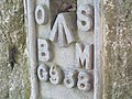 Ordnance Survey Flush Bracket G938 - geograph.org.uk - 3184012.jpg 3,264 × 2,448; 1.89 MB
-
 OS Cut Mark - Rothiemay, Bridge over the Deveron - geograph.org.uk - 4700166.jpg 2,448 × 3,264; 3.36 MB
-
 Plaque and Bell - geograph.org.uk - 4033417.jpg 427 × 640; 403 KB
-
 River Deveron - geograph.org.uk - 2579235.jpg 3,456 × 2,304; 1.92 MB
-
 River Deveron - geograph.org.uk - 4033664.jpg 640 × 427; 441 KB
-
 River Deveron - geograph.org.uk - 4033695.jpg 640 × 427; 370 KB
-
 River Deveron - geograph.org.uk - 4033727.jpg 640 × 427; 374 KB
-
 River Deveron - geograph.org.uk - 5453738.jpg 3,008 × 2,000; 3.3 MB
-
 River Deveron and Tower Hill - geograph.org.uk - 4033532.jpg 640 × 427; 374 KB
-
 Road (B9117) approaching Burnside - geograph.org.uk - 5963717.jpg 4,000 × 3,000; 3.17 MB
-
 Road (B9117) at Burnside - geograph.org.uk - 5963711.jpg 4,000 × 3,000; 3.62 MB
-
 Rothiemay Bridge - geograph.org.uk - 7017.jpg 640 × 402; 174 KB
-
 Rothiemay Church and Graveyard - geograph.org.uk - 747374.jpg 640 × 480; 118 KB
-
 Rothiemay Crossroads - geograph.org.uk - 3106977.jpg 1,811 × 1,095; 399 KB
-
 Rothiemay Crossroads - geograph.org.uk - 6209257.jpg 2,592 × 1,944; 1.27 MB
-
 Rothiemay crossroads. - geograph.org.uk - 255783.jpg 640 × 426; 87 KB
-
 Rothiemay Kirk - geograph.org.uk - 2579198.jpg 3,456 × 2,304; 1.6 MB
-
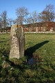
 Rothiemay Recumbent Stone Circle (1) - geograph.org.uk - 4742953.jpg 427 × 640; 605 KB
-
 Rothiemay Recumbent Stone Circle (10) - geograph.org.uk - 4743006.jpg 640 × 427; 483 KB
-
 Rothiemay Recumbent Stone Circle (11) - geograph.org.uk - 4743010.jpg 640 × 427; 451 KB
-
 Rothiemay Recumbent Stone Circle (12) - geograph.org.uk - 4743017.jpg 640 × 427; 459 KB
-
 Rothiemay Recumbent Stone Circle (13) - geograph.org.uk - 4743023.jpg 640 × 427; 537 KB
-
 Rothiemay Recumbent Stone Circle (14) - geograph.org.uk - 4743031.jpg 640 × 427; 527 KB
-
 Rothiemay Recumbent Stone Circle (15) - geograph.org.uk - 4743033.jpg 640 × 427; 505 KB
-
 Rothiemay Recumbent Stone Circle (16) - geograph.org.uk - 4743040.jpg 427 × 640; 434 KB
-
 Rothiemay Recumbent Stone Circle (17) - geograph.org.uk - 4743047.jpg 640 × 427; 531 KB
-
 Rothiemay Recumbent Stone Circle (18) - geograph.org.uk - 4743052.jpg 640 × 427; 522 KB
-
 Rothiemay Recumbent Stone Circle (19) - geograph.org.uk - 4743057.jpg 427 × 640; 456 KB
-
 Rothiemay Recumbent Stone Circle (2) - geograph.org.uk - 4742957.jpg 640 × 427; 372 KB
-
 Rothiemay Recumbent Stone Circle (20) - geograph.org.uk - 4743062.jpg 427 × 640; 458 KB
-
 Rothiemay Recumbent Stone Circle (21) - geograph.org.uk - 4743064.jpg 427 × 640; 497 KB
-
 Rothiemay Recumbent Stone Circle (3) - geograph.org.uk - 4742964.jpg 640 × 381; 386 KB
-
 Rothiemay Recumbent Stone Circle (4) - geograph.org.uk - 4742971.jpg 640 × 399; 375 KB
-
 Rothiemay Recumbent Stone Circle (5) - geograph.org.uk - 4742978.jpg 640 × 472; 461 KB
-
 Rothiemay Recumbent Stone Circle (6) - geograph.org.uk - 4742980.jpg 640 × 427; 480 KB
-
 Rothiemay Recumbent Stone Circle (7) - geograph.org.uk - 4742988.jpg 427 × 640; 469 KB
-
 Rothiemay Recumbent Stone Circle (8) - geograph.org.uk - 4742994.jpg 427 × 640; 459 KB
-
 Rothiemay Recumbent Stone Circle (9) - geograph.org.uk - 4743003.jpg 640 × 427; 441 KB
-
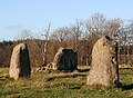
 Rothiemay Stones - geograph.org.uk - 5042399.jpg 1,800 × 952; 2.3 MB
-
 Shielparks - geograph.org.uk - 1720979.jpg 640 × 427; 269 KB
-
 Signpost for Netherton - geograph.org.uk - 3106987.jpg 1,824 × 1,368; 590 KB
-
 Site of Kirk - geograph.org.uk - 4033758.jpg 640 × 427; 395 KB
-
 South Retanach - geograph.org.uk - 4033441.jpg 640 × 427; 374 KB
-
 Spur Wood - geograph.org.uk - 4033517.jpg 640 × 427; 420 KB
-
 Spur Wood and Glennie - geograph.org.uk - 4033519.jpg 640 × 427; 373 KB
-
 Stone Circle at Rothiemay - geograph.org.uk - 5977406.jpg 1,024 × 683; 214 KB
-
 Stone Circle at Rothiemay - geograph.org.uk - 5977411.jpg 1,024 × 683; 219 KB
-
 The B9022 heading for Portsoy - geograph.org.uk - 6209258.jpg 2,592 × 1,944; 1.69 MB
-
 The Deveron Valley from the B9117 - geograph.org.uk - 2148830.jpg 1,024 × 768; 255 KB
-
 The River Deveron at Milltown of Rothiemay - geograph.org.uk - 6209254.jpg 2,592 × 1,944; 1.44 MB
-
 The River Deveron from Rothiemay Bridge - geograph.org.uk - 997611.jpg 640 × 427; 267 KB
-
 The View from South Retanach - geograph.org.uk - 4033452.jpg 640 × 427; 390 KB
-
 Timber Operations - geograph.org.uk - 4033553.jpg 640 × 427; 459 KB
-
 Toadstool - geograph.org.uk - 4743130.jpg 427 × 640; 359 KB
-
 Toadstool - geograph.org.uk - 4743131.jpg 475 × 640; 375 KB
-
 Toadstools - geograph.org.uk - 4743133.jpg 640 × 427; 497 KB
-
 Track from Auchincrieve joining the B9022 road - geograph.org.uk - 5963497.jpg 4,000 × 3,000; 4.21 MB
-
 Track into Craigmancie Wood - geograph.org.uk - 4033524.jpg 640 × 427; 410 KB
-
 Track into woods at Burnfield - geograph.org.uk - 6209255.jpg 2,592 × 1,944; 1.63 MB
-
 Track Junction - geograph.org.uk - 4033378.jpg 640 × 427; 458 KB
-
 Track near Moss-Side of Mayen - geograph.org.uk - 5977362.jpg 1,024 × 683; 212 KB
-
 Track through Farm Buildings at Auchincrieve - geograph.org.uk - 5963482.jpg 4,000 × 3,000; 3.05 MB
-
 Track to Auchincrieve - geograph.org.uk - 5963493.jpg 3,909 × 2,933; 3.26 MB
-
 Upper Woodside - geograph.org.uk - 4033394.jpg 640 × 427; 361 KB
-
 View from a minor road near South Retanach - geograph.org.uk - 5977400.jpg 1,024 × 683; 158 KB
-
 View north across the River Isla - geograph.org.uk - 2622312.jpg 2,592 × 1,944; 791 KB
-
 View North West from the Hill of Retenach - geograph.org.uk - 5977382.jpg 1,024 × 683; 167 KB
-
 View to Knock Hill - geograph.org.uk - 3106997.jpg 1,824 × 1,368; 614 KB
-
 View to Retanach - geograph.org.uk - 5977426.jpg 1,024 × 683; 184 KB
-
 View towards Knock Distillery - geograph.org.uk - 3105900.jpg 1,824 × 1,368; 924 KB
-
 Whins at Turtory - geograph.org.uk - 795563.jpg 640 × 427; 284 KB


_-_geograph.org.uk_-_4033430.jpg)
_-_geograph.org.uk_-_4033728.jpg)


_-_geograph.org.uk_-_4033432.jpg)


_approaching_Burnside_-_geograph.org.uk_-_5963717.jpg)
_at_Burnside_-_geograph.org.uk_-_5963711.jpg)


_-_geograph.org.uk_-_4742953.jpg)
_-_geograph.org.uk_-_4743006.jpg)
_-_geograph.org.uk_-_4743010.jpg)
_-_geograph.org.uk_-_4743017.jpg)
_-_geograph.org.uk_-_4743023.jpg)
_-_geograph.org.uk_-_4743031.jpg)
_-_geograph.org.uk_-_4743033.jpg)
_-_geograph.org.uk_-_4743040.jpg)
_-_geograph.org.uk_-_4743047.jpg)
_-_geograph.org.uk_-_4743052.jpg)
_-_geograph.org.uk_-_4743057.jpg)
_-_geograph.org.uk_-_4742957.jpg)
_-_geograph.org.uk_-_4743062.jpg)
_-_geograph.org.uk_-_4743064.jpg)
_-_geograph.org.uk_-_4742964.jpg)
_-_geograph.org.uk_-_4742971.jpg)
_-_geograph.org.uk_-_4742978.jpg)
_-_geograph.org.uk_-_4742980.jpg)
_-_geograph.org.uk_-_4742988.jpg)
_-_geograph.org.uk_-_4742994.jpg)
_-_geograph.org.uk_-_4743003.jpg)


