Category:Rue Carnot (Mâcon)
Jump to navigation
Jump to search
| Object location | | View all coordinates using: OpenStreetMap |
|---|
|
Rue Carnot (Mâcon) has an entry on OpenStreetMap (show). |
street in Mâcon  _-_2020-12-22_-_1.jpg) | |||||
| Upload media | |||||
| Instance of | |||||
|---|---|---|---|---|---|
| Part of | |||||
| Location | Mâcon, Saône-et-Loire, Bourgogne-Franche-Comté, Metropolitan France, France | ||||
 | |||||
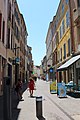
La rue Carnot est une rue parallèle au quai Lamartine, entre la place Poissonnière, la rue Sigogne, la rue Dombey, et la place Carnot.
Rue commerçante, elle donne accès à l'hôtel de ville (ancien hôtel Montrevel), à la résidence Soufflot (ancien hospice de la Charité), l'office de tourisme et l'église Saint-Pierre.
Subcategories
This category has the following 5 subcategories, out of 5 total.
Media in category "Rue Carnot (Mâcon)"
The following 28 files are in this category, out of 28 total.
-
 Mâcon - Rue Carnot -5.jpg 2,736 × 3,648; 1.59 MB
-
 Mâcon - Rue Carnot -7.jpg 2,736 × 3,648; 1.9 MB
-
 Mâcon - Rue Carnot -8.jpg 3,648 × 2,736; 4.79 MB
-
 Panneau Wifi Gratuit Rue Carnot - Mâcon (FR71) - 2020-12-22 - 1.jpg 3,024 × 4,032; 3.1 MB
-
 Place St Pierre (Mâcon, 2015).jpg 4,896 × 3,672; 6.69 MB
-
 Plaque Rue Carnot - Mâcon (FR71) - 2020-12-22 - 1.jpg 2,739 × 1,199; 795 KB
-
 Plaque Rue Carnot - Mâcon (FR71) - 2020-12-22 - 2.jpg 4,032 × 3,024; 4.5 MB
-
 Plaque rue Carnot Mâcon 1.jpg 5,184 × 3,456; 5.71 MB
-
 Plaque rue Carnot Mâcon 2.jpg 5,184 × 3,456; 6.1 MB
-
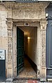 Porte sculptée, rue Carnot (Mâcon).jpg 2,232 × 3,576; 5.69 MB
-
 Rue Carnot - Mâcon (FR71) - 2021-07-17 - 1.jpg 3,024 × 4,032; 6.55 MB
-
 Rue Carnot - Mâcon (FR71) - 2021-07-17 - 2.jpg 4,032 × 3,024; 3.69 MB
-
 Rue Carnot - Mâcon (FR71) - 2024-03-15 - 1.jpg 3,024 × 4,032; 3.99 MB
-
 Rue Carnot - Mâcon (FR71) - 2024-03-15 - 2.jpg 4,032 × 3,024; 4.21 MB
-
 Rue Carnot - Mâcon (FR71) - 2024-07-04 - 1.jpg 4,032 × 3,024; 4.35 MB
-
 Rue Carnot - Mâcon (FR71) - 2024-07-04 - 2.jpg 3,024 × 4,032; 4.47 MB
-
 Rue Carnot Mâcon 1.jpg 5,184 × 3,456; 6.24 MB
-
 Rue Carnot Mâcon 2.jpg 5,184 × 3,456; 6.3 MB
-
 Rue Carnot Mâcon juillet 2019 1.jpg 3,456 × 5,184; 5.96 MB
-
 Rue Carnot Mâcon juillet 2019 2.jpg 3,456 × 5,184; 3.84 MB
-
 Rue Carnot Mâcon juillet 2019 3.jpg 5,184 × 3,456; 7.24 MB
-
 Rue Carnot Mâcon juillet 2019 4.jpg 3,456 × 5,184; 6.7 MB
-
 Rue Carnot Mâcon juillet 2019 5.jpg 3,456 × 5,184; 4.74 MB
-
 Rue Carnot Mâcon juillet 2019 6.jpg 3,456 × 5,184; 4.67 MB
-
 Rue Carnot Mâcon juillet 2019 7.jpg 5,184 × 3,456; 4.49 MB
-
 Rue Carnot Mâcon juillet 2019 8.jpg 5,184 × 3,456; 4.94 MB
-
 Un camion sur une zone de travaux à Mâcon en janvier 2021.jpg 3,674 × 2,415; 5.87 MB
-
 Une boîte aux lettres, rue Carnot à Mâcon.jpg 2,232 × 2,336; 3.71 MB


_-_2020-12-22_-_1.jpg)
.jpg)
_-_2020-12-22_-_2.jpg)


.jpg)
_-_2021-07-17_-_1.jpg)
_-_2021-07-17_-_2.jpg)
_-_2024-03-15_-_1.jpg)
_-_2024-03-15_-_2.jpg)
_-_2024-07-04_-_1.jpg)
_-_2024-07-04_-_2.jpg)


