Category:Ruins of romanesque church in Svodín
Jump to navigation
Jump to search
| This category shows the protected monument with the number 404-366/0 (other) in the Slovak Republic. |
| Camera location | | View all coordinates using: OpenStreetMap |
|---|
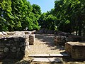
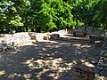
Slovenčina: Zakonzervované základy románskeho Kostola svätého Michala v časti Maďarský Svodín
Media in category "Ruins of romanesque church in Svodín"
The following 5 files are in this category, out of 5 total.
-
 Svodín základy kostola 01.jpg 4,000 × 3,000; 7.36 MB
-
 Svodín základy kostola 02.jpg 4,000 × 3,000; 8.36 MB
-
 Svodín základy kostola 03.jpg 4,000 × 3,000; 8.35 MB
-
 Svodín základy kostola 04.jpg 4,000 × 3,000; 8.14 MB
-
 Svodín základy kostola 05.jpg 3,000 × 4,000; 2.47 MB


