Category:SVG maps of Poland
Jump to navigation
Jump to search
Subcategories
This category has the following 18 subcategories, out of 18 total.
D
- SVG maps of Dębica (13 F)
E
F
- SVG flag maps of Poland (18 F)
K
- SVG maps of Krosno (15 F)
L
N
- SVG maps of Nowy Sącz (29 F)
P
R
S
- SVG maps of Gorlice County (1 F)
- SVG maps of Świętochłowice (3 F)
T
- SVG maps of Tarnów (19 F)
- SVG transport maps of Poland (20 F)
W
Media in category "SVG maps of Poland"
The following 200 files are in this category, out of 232 total.
(previous page) (next page)-
 1989 Polish parliamentary election.svg 512 × 256; 488 KB
-
 1989 Sejm constituencies.svg 512 × 488; 280 KB
-
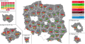
 1991 Polish parliamentary election - Results.svg 1,782 × 916; 1.76 MB
-
 1991 Polish parliamentary election - Vote Strength.svg 1,440 × 930; 210 KB
-
 1991 Polish parliamentary election.svg 512 × 256; 468 KB
-
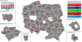
 1993 Polish parliamentary election - Results.svg 1,782 × 916; 1.17 MB
-
 1993 Polish parliamentary election - Vote Strength.svg 1,172 × 930; 209 KB
-
 1993 Polish parliamentary election.svg 512 × 256; 293 KB
-
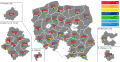
 1997 Polish parliamentary election - Results.svg 1,782 × 916; 1.11 MB
-
 1997 Polish parliamentary election - Vote Strength.svg 1,028 × 930; 207 KB
-
 1997 Polish parliamentary election.svg 512 × 256; 291 KB
-
 2001 Polish parliamentary election - Results.svg 1,782 × 916; 1.07 MB
-
 2001 Polish parliamentary election - Vote Strength.svg 1,028 × 930; 328 KB
-
 2001 Polish parliamentary election.svg 512 × 256; 324 KB
-
 2005 Polish parliamentary election - Results.svg 1,782 × 916; 1.1 MB
-
 2005 Polish parliamentary election - Vote Strength.svg 1,028 × 930; 322 KB
-
 2005 Polish parliamentary election.svg 512 × 256; 324 KB
-
 2007 Polish parliamentary election - Results.svg 1,782 × 916; 990 KB
-
 2007 Polish parliamentary election - Vote Strength.svg 1,028 × 930; 322 KB
-
 2007 Polish parliamentary election.svg 512 × 256; 321 KB
-
 2011 Polish parliamentary election - Results.svg 1,782 × 916; 1.01 MB
-
 2011 Polish parliamentary election - Vote Strength.svg 1,028 × 930; 322 KB
-
 2011 Polish parliamentary election.svg 512 × 256; 322 KB
-
 2015 Polish parliamentary election.svg 512 × 256; 324 KB
-
 2019 Polish parliamentary election - Results.svg 1,782 × 916; 994 KB
-
 2019 Polish parliamentary election - Senate Vote Strength.svg 1,083 × 777; 1.88 MB
-
 2019 Polish parliamentary election - Vote Strength.svg 1,076 × 930; 327 KB
-
 2019 Polish parliamentary election.svg 512 × 256; 324 KB
-
 20211231MapaS61.svg 776 × 723; 158 KB
-
 2023 Polish parliamentary election.svg 512 × 256; 321 KB
-
 Administrative division of Poland (1946).svg 600 × 560; 112 KB
-
 Administrative division of Poland (1957).svg 600 × 560; 134 KB
-
 Arkusze mapy 10k w układzie 1965.svg 619 × 575; 256 KB
-
 Armut NUTS1 Polen.svg 512 × 256; 138 KB
-
 Bistum Bielsko-Żywiec.svg 512 × 484; 70 KB
-
 Bistum Bydgoszcz.svg 512 × 484; 70 KB
-
 Bistum Drohiczyn.svg 512 × 484; 70 KB
-
 Bistum Elbląg.svg 512 × 484; 70 KB
-
 Bistum Ełk.svg 512 × 484; 70 KB
-
 Bistum Gliwice.svg 512 × 484; 70 KB
-
 Bistum Kalisz.svg 512 × 484; 70 KB
-
 Bistum Kielce.svg 512 × 484; 70 KB
-
 Bistum Koszalin-Kołobrzeg.svg 512 × 484; 70 KB
-
 Bistum Legnica.svg 512 × 484; 70 KB
-
 Bistum Opole.svg 512 × 484; 70 KB
-
 Bistum Pelplin.svg 512 × 484; 70 KB
-
 Bistum Płock.svg 512 × 484; 70 KB
-
 Bistum Rzeszów.svg 512 × 484; 70 KB
-
 Bistum Sandomierz.svg 512 × 484; 70 KB
-
 Bistum Siedlce.svg 512 × 484; 70 KB
-
 Bistum Tarnów.svg 512 × 484; 70 KB
-
 Bistum Toruń.svg 512 × 484; 70 KB
-
 Bistum Włocławek.svg 512 × 484; 70 KB
-
 Bistum Zamość-Lubaczów.svg 512 × 484; 70 KB
-
 Bistum Zielona Góra-Gorzów Wielkopolski.svg 512 × 484; 70 KB
-
 Bistum Łomża.svg 512 × 484; 70 KB
-
 Bistum Łowicz.svg 512 × 484; 70 KB
-
 Bistum Świdnica.svg 512 × 484; 70 KB
-
 CatholicDiocesesPoland2004-it.svg 1,500 × 1,413; 205 KB
-
 CatholicDiocesesPoland2004.svg 1,500 × 1,413; 563 KB
-
 CatholicDiocesesPoland2004Numbered.svg 1,500 × 1,413; 148 KB
-
 Chlewice plan wsi.svg 1,500 × 1,500; 502 KB
-
 COVID-19 Pandemic Cases in Poland Powiats.svg 1,406 × 1,339; 319 KB
-
 Distribution of Marmota marmota latirostris.svg 862 × 838; 351 KB
-
 Dojazd.svg 2,400 × 1,600; 826 KB
-
 Dominicantes2014.svg 568 × 568; 1.39 MB
-
 Erzbistum Białystok.svg 512 × 484; 70 KB
-
 Erzbistum Breslau.svg 512 × 484; 70 KB
-
 Erzbistum Danzig.svg 512 × 484; 70 KB
-
 Erzbistum Ermland.svg 512 × 484; 70 KB
-
 Erzbistum Gniezno.svg 512 × 484; 70 KB
-
 Erzbistum Katowice.svg 512 × 484; 70 KB
-
 Erzbistum Krakau.svg 512 × 484; 70 KB
-
 Erzbistum Lublin.svg 512 × 484; 70 KB
-
 Erzbistum Posen.svg 512 × 484; 70 KB
-
 Erzbistum Przemyśl.svg 512 × 484; 70 KB
-
 Erzbistum Szczecin-Kamień.svg 512 × 484; 70 KB
-
 Erzbistum Warschau.svg 512 × 484; 70 KB
-
 Erzbistum Łódź.svg 512 × 484; 70 KB
-
 EYD 2019 Map.svg 680 × 540; 692 KB
-
 Gmina Ostaszewo in Nowy Dwór Gdański powiat.svg 940 × 700; 263 KB
-
 Gminy Polski według rodzaju.svg 800 × 744; 2.03 MB
-
 Gminy powiatu wloszczowskiego.svg 1,772 × 2,126; 24 KB
-
 Granice ziem państwa Mieszka I 963.svg 606 × 623; 171 KB
-
 Granice ziem państwa Mieszka I 992-es.svg 606 × 623; 60 KB
-
 Granice ziem państwa Mieszka I 992.svg 606 × 623; 194 KB
-
 Janiszew - lokacje.svg 580 × 630; 55 KB
-
 Kaszubians in Poland.svg 2,750 × 2,600; 24 KB
-
 Kielce-outlined.svg 2,305 × 2,087; 33 KB
-
 Kirchenprovinz Białystok.svg 512 × 484; 70 KB
-
 Kirchenprovinz Breslau.svg 512 × 484; 70 KB
-
 Kirchenprovinz Danzig.svg 512 × 484; 70 KB
-
 Kirchenprovinz Ermland.svg 512 × 484; 70 KB
-
 Kirchenprovinz Gniezno.svg 512 × 484; 70 KB
-
 Kirchenprovinz Katowice.svg 512 × 484; 70 KB
-
 Kirchenprovinz Krakau.svg 512 × 484; 70 KB
-
 Kirchenprovinz Lublin.svg 512 × 484; 70 KB
-
 Kirchenprovinz Posen.svg 512 × 484; 70 KB
-
 Kirchenprovinz Przemyśl.svg 512 × 484; 70 KB
-
 Kirchenprovinz Szczecin-Kamień.svg 512 × 484; 70 KB
-
 Kirchenprovinz Warschau.svg 512 × 484; 70 KB
-
 Kirchenprovinz Łódź.svg 512 × 484; 70 KB
-
 Kirchenprovinzen in Polen.svg 512 × 484; 70 KB
-
 Locator map of Poland.svg 680 × 520; 657 KB
-
 Locator map of Rogoźno - Wielkopolskie Voivodship.svg 450 × 600; 109 KB
-
 Map of Poland new ISO-3166-2 PL (2018).svg 862 × 838; 764 KB
-
 Map of Poland on fbi.svg 418 × 447; 26 KB
-
 Map of poland without names.svg 461 × 425; 468 KB
-
 Mapa Janiszewa (wojewódzrwo wielkopolskie).svg 580 × 630; 48 KB
-
 Mapa sądów w Polsce 1.06.2022 - Map of courts in Poland 1.06.2022.svg 1,063 × 992; 56.14 MB
-
 Miejscowości wiejskie wg gmin i liczby grafik w Commons.svg 1,406 × 1,406; 3.44 MB
-
 Miejscowości wiejskie wg gmin i rozmiaru w bajtach.svg 1,600 × 1,600; 3.41 MB
-
 Miejscowości wiejskie wg gmin, wielkości w bajtach i liczby grafik.svg 1,500 × 1,500; 3.43 MB
-
 Niemka 2011 06 09 17 58 43.0.svg 1,188 × 971; 96 KB
-
 Olsztyn-dzelnice.svg 810 × 705; 67 KB
-
 POL location map.svg 497 × 463; 48 KB
-
 POL Voivodships 1975.svg 3,238 × 2,952; 192 KB
-
 POL Woj Podlaskie-linie kolejowe.svg 390 × 560; 22 KB
-
 POL województwo bialopodlaskie 1975.svg 3,238 × 2,952; 193 KB
-
 POL województwo bialostockie 1975.svg 3,238 × 2,952; 193 KB
-
 POL województwo białostockie 1950.svg 3,294 × 3,074; 57 KB
-
 POL województwo bielskie 1975.svg 3,238 × 2,952; 193 KB
-
 POL województwo bydgoskie 1950.svg 3,294 × 3,074; 57 KB
-
 POL województwo bydgoskie 1975.svg 3,238 × 2,952; 193 KB
-
 POL województwo chelmskie 1975.svg 3,238 × 2,952; 193 KB
-
 POL województwo ciechanowskie 1975.svg 3,238 × 2,952; 193 KB
-
 POL województwo czestochowskie 1975.svg 3,238 × 2,952; 193 KB
-
 POL województwo elblaskie 1975.svg 3,238 × 2,952; 193 KB
-
 POL województwo gdanskie 1975.svg 3,238 × 2,952; 193 KB
-
 POL województwo gdańskie 1950.svg 3,294 × 3,074; 57 KB
-
 POL województwo gorzowskie 1975.svg 3,238 × 2,952; 193 KB
-
 POL województwo jeleniogorskie 1975.svg 3,238 × 2,952; 194 KB
-
 POL województwo kaliskie 1975.svg 3,238 × 2,952; 194 KB
-
 POL województwo katowickie 1950.svg 3,294 × 3,074; 58 KB
-
 POL województwo katowickie 1975.svg 3,238 × 2,952; 194 KB
-
 POL województwo kieleckie 1938.svg 3,280 × 3,682; 66 KB
-
 POL województwo kieleckie 1950.svg 3,294 × 3,074; 56 KB
-
 POL województwo koszalińskie 1950.svg 3,294 × 3,074; 57 KB
-
 POL województwo krakowskie 1950.svg 3,294 × 3,074; 58 KB
-
 POL województwo krakowskie 1975.svg 3,238 × 2,952; 193 KB
-
 POL województwo legnickie 1975.svg 3,238 × 2,952; 193 KB
-
 POL województwo leszczynskie 1975.svg 3,238 × 2,952; 193 KB
-
 POL województwo lodzkie 1975.svg 3,238 × 2,952; 193 KB
-
 POL województwo lomzynskie 1975.svg 3,238 × 2,952; 193 KB
-
 POL województwo lubelskie 1950.svg 3,294 × 3,074; 58 KB
-
 POL województwo lubelskie 1975.svg 3,238 × 2,952; 193 KB
-
 POL województwo małopolskie map.svg 3,556 × 3,188; 216 KB
-
 POL województwo olsztyńskie 1950.svg 3,294 × 3,074; 57 KB
-
 POL województwo opolskie 1950.svg 3,294 × 3,074; 58 KB
-
 POL województwo poznańskie 1950.svg 3,294 × 3,074; 57 KB
-
 POL województwo szczecińskie 1950.svg 3,294 × 3,074; 57 KB
-
 POL województwo warszawskie 1950.svg 3,294 × 3,074; 57 KB
-
 POL województwo wrocławskie 1950.svg 3,294 × 3,074; 58 KB
-
 POL województwo zielonogórskie 1950.svg 3,294 × 3,074; 57 KB
-
 POL województwo łódzkie 1950.svg 3,294 × 3,074; 58 KB
-
 Poland - shape.svg 600 × 600; 8 KB
-
 Poland adm location map.svg 861 × 837; 340 KB
-
 Poland administrative divisions comparison map (1999 and pre-1999).svg 1,000 × 933; 2.26 MB
-
 Poland eastern part location map.svg 540 × 837; 446 KB
-
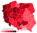
 Poland general election 2015 - Results by Sejm District.svg 1,782 × 916; 809 KB
-
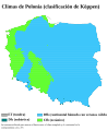 Poland Köppen-es.svg 765 × 936; 666 KB
-
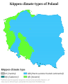 Poland Köppen.svg 765 × 936; 697 KB
-
 Poland location map 3.svg 808 × 785; 2.52 MB
-
 Poland location map Pomeranian West Pomeranian.svg 501 × 349; 609 KB
-
 Poland location map white.svg 862 × 838; 350 KB
-
 Poland location map.svg 861 × 837; 213 KB
-
 Poland OlympusMons Size.svg 500 × 500; 163 KB
-
 Poland telephone area codes.svg 3,238 × 2,952; 198 KB
-
 Poland western part location map.svg 515 × 837; 617 KB
-
 Poland2 location map.svg 861 × 837; 341 KB
-
 Polish car number plates - codes of voivodeships.svg 2,061 × 1,925; 306 KB
-
 Polish Powiats outlines.svg 820 × 775; 1.52 MB
-
 Polish referendum results 1997.svg 3,238 × 2,952; 193 KB
-
 Polish voivodeships by HDI (2017).svg 512 × 512; 92 KB
-
 Polish voivodeships mk.svg 2,061 × 1,925; 111 KB
-
 Polska map blank.svg 744 × 1,052; 9 KB
-
 Polska parki przemysłowe.svg 1,827 × 1,672; 154 KB
-
 Polska podział admin dolnoslaskie.svg 461 × 425; 214 KB
-
 Polska podział admin kujawsko pomorskie.svg 461 × 425; 127 KB
-
 Polska podział admin lodzkie.svg 461 × 425; 127 KB
-
 Polska podział admin lubelskie.svg 461 × 425; 127 KB
-
 Polska podział admin lubuskie.svg 461 × 425; 214 KB
-
 Polska podział admin malopolskie.svg 461 × 425; 127 KB
-
 Polska podział admin mazowieckie.svg 461 × 425; 127 KB
-
 Polska podział admin opolskie.svg 461 × 425; 214 KB
-
 Polska podział admin podkarpackie.svg 461 × 425; 127 KB
-
 Polska podział admin podlaskie.svg 461 × 425; 127 KB
-
 Polska podział admin pomorskie.svg 461 × 425; 127 KB
-
 Polska podział admin slaskie.svg 461 × 425; 127 KB
-
 Polska podział admin swietokrzyskie.svg 461 × 425; 127 KB
-
 Polska podział admin warminsko mazurskie.svg 461 × 425; 127 KB
-
 Polska podział admin wiekopolskie.svg 461 × 425; 127 KB
-
 Polska podział admin zachodniopomorskie.svg 461 × 425; 127 KB
-
 Polska podział admin.svg 461 × 425; 330 KB
-
 POLSKA powiaty (województwa).svg 1,406 × 1,339; 323 KB
-
 POLSKA powiaty.svg 1,406 × 1,339; 323 KB
-
 Polska-GBystrzyckie.svg 600 × 600; 34 KB
-
 Polska-glowne rzeki.svg 600 × 600; 23 KB
-
 Polska-GOrlickie.svg 600 × 600; 34 KB
-
 Polska-GStolowe.svg 600 × 600; 34 KB


.svg)
.svg)


.svg)


.svg)


.svg)


.svg)


.svg)


