Category:SVG maps of disputed territories in South America
Jump to navigation
Jump to search
Subcategories
This category has only the following subcategory.
Media in category "SVG maps of disputed territories in South America"
The following 59 files are in this category, out of 59 total.
-
 1893 border protocol between Argentina & Chile.svg 694 × 589; 916 KB
-
 1902 Andes Boundary Case de.svg 537 × 645; 1.02 MB
-
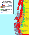 1902 Andes Boundary Case.svg 1,430 × 1,720; 1.47 MB
-
 Argentina disputed w1 countrymap.svg 1,000 × 1,000; 47 KB
-
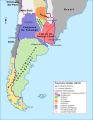
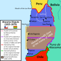 Atacama Desert Dispute between Bolivia and Chile (1825 - 1879).svg 1,500 × 1,500; 3.41 MB
-
 Brazil disputed w1 countrymap.svg 1,000 × 1,000; 39 KB
-
 Chile disputed w1 countrymap.svg 1,000 × 1,000; 30 KB
-
 Chile location map (+claims, 1775).svg 1,710 × 2,679; 2.2 MB
-
 Chile location map (+claims, 1776).svg 1,710 × 2,679; 3.06 MB
-
 Chile location map (+claims, 1899).svg 1,183 × 2,679; 1.19 MB
-
 Chile location map (+claims, 1900).svg 1,183 × 2,679; 1.04 MB
-
 Chile location map (+claims, 1903).svg 1,183 × 2,679; 1.01 MB
-
 Chile location map (+claims, 1904).svg 1,183 × 2,679; 1 MB
-
 Colombia disputed w1 countrymap.svg 1,000 × 1,000; 37 KB
-
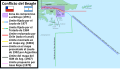 Conflicto del Beagle.svg 1,355 × 772; 1.9 MB
-
 Cuestion de Tarija.svg 2,240 × 2,573; 240 KB
-
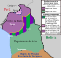
 Cuestión de Tacna y Arica.svg 3,954 × 3,837; 1.03 MB
-
 Cuyo en la Capitanía General de Chile.svg 1,710 × 2,679; 2.53 MB
-
 Departamento de Arica, Chile.svg 3,093 × 2,937; 787 KB
-
 Diferendo Golfo de Venezuela.svg 1,030 × 919; 34 KB
-
 Disputa de la Laguna del Desierto.svg 1,205 × 1,063; 2.62 MB
-

-
 Disputa limítrofe de Alto Palena.svg 1,772 × 2,776; 1.29 MB
-
 Disputa limítrofe del desierto de Atacama entre Bolivia y Chile (1825 - 1879).svg 1,500 × 1,500; 3.5 MB
-
 Dispute sur le Laguna del Desierto.svg 1,205 × 1,063; 2.65 MB
-

-
 France 1 disputed w1 countrymap.svg 1,000 × 1,000; 100 KB
-
 Guyana disputed w1 countrymap.svg 1,000 × 1,000; 20 KB
-
 Laguna del Desierto dispute.svg 1,205 × 1,063; 2.65 MB
-
 Laudo limítrofe entre Argentina y Chile de 1902.svg 1,430 × 1,720; 1.51 MB
-
 Litigio de la Puna de Atacama.svg 414 × 491; 677 KB
-
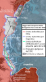 Límites Campo de Hielo Patagónico Sur antes de 1994.svg 935 × 1,641; 2.62 MB
-
 Límites Campo de Hielo Patagónico Sur.svg 935 × 1,641; 2.73 MB
-
 Mapa de argentina en 1816.svg 1,003 × 1,297; 408 KB
-
 Mapa de Chile, año 1899.svg 1,183 × 2,679; 1.24 MB
-
 Mapa de Chile, año 1900.svg 1,183 × 2,679; 1.27 MB
-
 Mapa de Chile, año 1903.svg 1,183 × 2,679; 1.24 MB
-
 Mapa de Chile, año 1904.svg 1,183 × 2,679; 1.23 MB
-
 Mapa questão do Pirara-es.svg 583 × 645; 199 KB
-
 Mapa questão do Pirara.svg 583 × 645; 199 KB
-
 Protocolo de límites de 1893 entre Argentina y Chile.svg 694 × 589; 929 KB
-
 Provincia de Tacna, Chile (1884-1925).svg 2,268 × 2,764; 285 KB
-
 Provincia de Tacna, Chile (1925-1929).svg 2,268 × 2,764; 252 KB
-
 Puna de Atacama dispute.svg 414 × 491; 649 KB
-
 Pérdidas territoriales de iure de la República de Chile.svg 1,800 × 2,808; 3.84 MB
-
 Southern Patagonian Ice Field border.svg 935 × 1,641; 2.64 MB
-
 Southern Patagonian Ice Field dispute before 1994.svg 935 × 1,641; 2.45 MB
-
 Suriname disputed w1 countrymap.svg 1,000 × 1,000; 11 KB
-
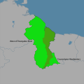
 Suriname location map.svg 1,181 × 1,205; 269 KB
-
 Tacna province (1884-1925) Chile location map.svg 2,268 × 2,764; 146 KB
-
 Tacna province (1925-1929) Chile location map.svg 2,268 × 2,764; 80 KB
-
 Tacna-Arica Dispute (1883-1929).svg 3,954 × 3,837; 1 MB
-
 Territorial losses of the Republic of Chile de jure.svg 1,800 × 2,808; 3.75 MB
-
 Tratado de Ancón.svg 4,591 × 6,024; 547 KB
-
 Treaty of Ancón.svg 4,606 × 6,024; 513 KB
-
 United Kingdom 1 disputed w1 countrymap.svg 1,000 × 1,000; 179 KB
-
 United Kingdom 2 disputed w1 countrymap.svg 1,000 × 1,000; 106 KB
-
 Uruguay disputed w1 countrymap.svg 1,000 × 1,000; 9 KB
-
 Venezuela disputed w1 countrymap.svg 1,000 × 1,000; 23 KB


.svg)


.svg)
.svg)
.svg)
.svg)
.svg)
.svg)


.svg)

.svg)

.svg)


.svg)
.svg)


_Chile_location_map.svg)
_Chile_location_map.svg)
.svg)


