Category:Salir Museum
Jump to navigation
Jump to search

| Object location | | View all coordinates using: OpenStreetMap |
|---|
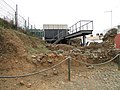
English: Salir Archaeology Museum and interpretation centre first opened in May 2006. The museum is part built above an excavated area of the Salir castle archaeological digs of 1987 and 1998, and was designed by architect Mário Varela Gomes.
Media in category "Salir Museum"
The following 4 files are in this category, out of 4 total.
-
 21-05-2017 Museum on Largo Pedro Dias, Salir.JPG 4,608 × 3,456; 3.99 MB
-
 21-05-2017 Ruínas do Castelo de Salir (4).JPG 4,608 × 3,456; 5.33 MB
-
 21-05-2017 Ruínas do Castelo de Salir (5).JPG 4,608 × 3,456; 5.55 MB
-
 21-05-2017 Travessa do Castelo, Salir.JPG 4,608 × 3,456; 4.22 MB

.JPG)
.JPG)
