Category:Sanborn maps of Manhattan published in 1890
Jump to navigation
Jump to search
Maps from:
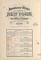
- Insurance Maps of the City of New York Surveyed and Published by Sanborn–Perris Map Co., Limited. Volume 4. (New York: 1890), comprising 19 maps (double-page plates) numbered 67, 67½, and 68–84, plus title page and volume key (volume key extends to title page);
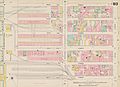
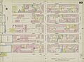
- Insurance Maps of the City of New York Surveyed and Published by Sanborn–Perris Map Co., Limited. Volume 5. (New York: 1890), comprising 19 maps (double-page plates) numbered 85–102 and an unnumbered map (double-page plate) of the Hudson River piers, plus title page and volume key (volume key extends to title page).
Source: The New York Public Library Digital Collections website, Atlas 42.54. Vol. 4, 1890 and Atlas 42.55. Vol. 5, 1890.
Subcategories
This category has only the following subcategory.
Media in category "Sanborn maps of Manhattan published in 1890"
The following 44 files are in this category, out of 44 total.
-
 Sanborn Manhattan V. 4 title page publ. 1890.jpg 5,193 × 7,400; 6.15 MB
-
 Sanborn Manhattan V. 4 volume key publ. 1890.jpg 5,663 × 7,310; 5.75 MB
-
 Sanborn Manhattan V. 5 title page publ. 1890.jpg 5,233 × 7,562; 6.58 MB
-
 Sanborn Manhattan V. 5 volume key publ. 1890.jpg 5,159 × 7,458; 5.86 MB
-
 Sanborn Manhattan V. 5 volume key (small) publ. 1890.jpg 1,697 × 2,440; 881 KB
-

-
 Sanborn Manhattan V. 4 Plate 67 publ. 1890.jpg 8,061 × 5,846; 7.43 MB
-
 Sanborn Manhattan V. 4 Plate 67½ publ. 1890.jpg 8,122 × 5,877; 5.38 MB
-
 Sanborn Manhattan V. 4 Plate 68 publ. 1890.jpg 8,214 × 5,917; 8.24 MB
-
 Sanborn Manhattan V. 4 Plate 69 publ. 1890.jpg 8,214 × 5,882; 7.72 MB
-
 Sanborn Manhattan V. 4 Plate 70 publ. 1890.jpg 8,242 × 5,927; 7.14 MB
-
 Sanborn Manhattan V. 4 Plate 71 publ. 1890.jpg 8,247 × 5,890; 8.14 MB
-
 Sanborn Manhattan V. 4 Plate 72 publ. 1890.jpg 8,247 × 5,917; 9 MB
-
 Sanborn Manhattan V. 4 Plate 73 publ. 1890.jpg 8,144 × 5,961; 7.47 MB
-
 Sanborn Manhattan V. 4 Plate 74 publ. 1890.jpg 8,172 × 5,929; 8.29 MB
-
 Sanborn Manhattan V. 4 Plate 75 publ. 1890.jpg 8,191 × 5,845; 7.95 MB
-
 Sanborn Manhattan V. 4 Plate 76 publ. 1890.jpg 8,178 × 5,936; 7.01 MB
-
 Sanborn Manhattan V. 4 Plate 77 publ. 1890.jpg 8,113 × 5,870; 8.55 MB
-
 Sanborn Manhattan V. 4 Plate 78 publ. 1890.jpg 8,223 × 5,877; 7.65 MB
-
 Sanborn Manhattan V. 4 Plate 79 publ. 1890.jpg 8,103 × 5,865; 7.1 MB
-
 Sanborn Manhattan V. 4 Plate 80 publ. 1890.jpg 8,160 × 5,862; 8.48 MB
-
 Sanborn Manhattan V. 4 Plate 81 publ. 1890.jpg 8,175 × 5,847; 8.17 MB
-
 Sanborn Manhattan V. 4 Plate 82 publ. 1890.jpg 8,165 × 5,829; 6.98 MB
-
 Sanborn Manhattan V. 4 Plate 83 publ. 1890.jpg 8,171 × 5,878; 7.83 MB
-
 Sanborn Manhattan V. 4 Plate 84 publ. 1890.jpg 8,216 × 5,850; 7.88 MB
-
 Sanborn Manhattan V. 5 Plate 85 publ. 1890.jpg 8,091 × 5,907; 7.35 MB
-
 Sanborn Manhattan V. 5 Plate 86 publ. 1890.jpg 8,093 × 5,844; 6.99 MB
-
 Sanborn Manhattan V. 5 Plate 87 publ. 1890.jpg 8,109 × 5,950; 7.01 MB
-
 Sanborn Manhattan V. 5 Plate 88 publ. 1890.jpg 8,144 × 5,925; 7.54 MB
-
 Sanborn Manhattan V. 5 Plate 89 publ. 1890.jpg 8,088 × 5,850; 7.17 MB
-
 Sanborn Manhattan V. 5 Plate 90 publ. 1890.jpg 8,130 × 5,950; 7.13 MB
-
 Sanborn Manhattan V. 5 Plate 91 publ. 1890.jpg 8,084 × 5,971; 7.48 MB
-
 Sanborn Manhattan V. 5 Plate 92 publ. 1890.jpg 8,094 × 5,894; 7.09 MB
-
 Sanborn Manhattan V. 5 Plate 93 publ. 1890.jpg 8,130 × 5,866; 7.65 MB
-
 Sanborn Manhattan V. 5 Plate 94 publ. 1890.jpg 8,085 × 5,896; 7.11 MB
-
 Sanborn Manhattan V. 5 Plate 95 publ. 1890.jpg 8,064 × 5,877; 7.15 MB
-
 Sanborn Manhattan V. 5 Plate 96 publ. 1890.jpg 8,139 × 5,925; 7.21 MB
-
 Sanborn Manhattan V. 5 Plate 97 publ. 1890.jpg 8,120 × 5,858; 7.45 MB
-
 Sanborn Manhattan V. 5 Plate 98 publ. 1890.jpg 8,002 × 5,866; 7.52 MB
-
 Sanborn Manhattan V. 5 Plate 99 publ. 1890.jpg 8,094 × 5,905; 7.37 MB
-
 Sanborn Manhattan V. 5 Plate 100 publ. 1890.jpg 8,100 × 5,946; 6.99 MB
-
 Sanborn Manhattan V. 5 Plate 101 publ. 1890.jpg 8,091 × 5,977; 7.75 MB
-
 Sanborn Manhattan V. 5 Plate 102 publ. 1890.jpg 8,080 × 5,917; 6.84 MB
-
 Sanborn Manhattan V. 5 Hudson River piers publ. 1890.jpg 8,104 × 5,903; 6.07 MB


_publ._1890.jpg)
.jpg)


