Category:Sanborn maps of Staten Island published in 1917, V. 1
Jump to navigation
Jump to search
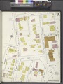
Maps from: Borough of Richmond Insurance Maps of Staten Island New York. Volume 1. (New York: Sanborn Map Company, 1917), comprising 75 maps (plates) plus (missing from this category) title page, street index, and volume key.
Online at The New York Public Library Digital Collections website, Atlas 162. Vol. 1, 1917.
NYPL searchable Image ID numbers:
- Title page: 1957323
- Street index: 1957324
- Volume key: 1957325 (northeastern portion of Staten Island)
- Plate 11 (1917): 1957338
- Plate 11 (January 1923): 1957337
- Plate 14 (1917): 1957341
- Plate 14 (April 1921): 1957342
- Plate 70 (January 1919) (miscaptioned by NYPL and here as Plate No. 73): 1957401
- Plate 70 (April 1921): 1957398
- Plate 71 (April 1921): 1957399
- Plate 72 (January 1923): 1957400
Media in category "Sanborn maps of Staten Island published in 1917, V. 1"
The following 75 files are in this category, out of 75 total.
-
 Staten Island, V. 1, Plate No. 1 (Map bounded by Kill van Kull, Westervelt Ave., York Ave.) NYPL1957327.tiff 5,382 × 7,158, 2 pages; 110.28 MB
-
 Staten Island, V. 1, Plate No. 10 (Map bounded by Hannah, Bay, Grant, St. Paul's Ave.) NYPL1957336.tiff 5,382 × 7,158, 2 pages; 110.28 MB
-
 Staten Island, V. 1, Plate No. 11 (1917) (Map bounded by Crescent Ave., Sherman Ave., Brook, Jersey) NYPL1957338.tiff 5,382 × 7,158, 2 pages; 110.28 MB
-
 Staten Island, V. 1, Plate No. 11 (1923) (Map bounded by Crescent Ave., Sherman Ave., Brook, Jersey) NYPL1957337.tiff 5,382 × 7,158, 2 pages; 110.28 MB
-
 Staten Island, V. 1, Plate No. 12 (Map bounded by Borough Pl., Upper New York Bay, Hannah, Bay) NYPL1957339.tiff 5,382 × 7,158, 2 pages; 110.28 MB
-
 Staten Island, V. 1, Plate No. 13 (Map bounded by Grant, Bay, William, St. Paul's Ave.) NYPL1957340.tiff 5,382 × 7,158, 2 pages; 110.28 MB
-
 Staten Island, V. 1, Plate No. 14 (1917) (Map bounded by Bay, Upper New York Bay, Canal) NYPL1957341.tiff 5,382 × 7,158, 2 pages; 110.28 MB
-
 Staten Island, V. 1, Plate No. 14 (1921) (Map bounded by Bay, Upper New York Bay, Canal) NYPL1957342.tiff 5,382 × 7,158, 2 pages; 110.28 MB
-
 Staten Island, V. 1, Plate No. 15 (Map bounded by William, Van Duzer, Beach, St. Paul's Ave.) NYPL1957343.tiff 5,357 × 7,110, 2 pages; 109.03 MB
-
 Staten Island, V. 1, Plate No. 16 (Map bounded by William, Bay, Union Pl., Beach, Van Duzer) NYPL1957344.tiff 5,382 × 7,158, 2 pages; 110.28 MB
-
 Staten Island, V. 1, Plate No. 17 (Map bounded by Beach, Van Duzer, Stone, St. Paul's Ave.) NYPL1957345.tiff 5,382 × 7,158, 2 pages; 110.28 MB
-
 Staten Island, V. 1, Plate No. 18 (Map bounded by Van Duzer, Beach, Water, Boyd, Court) NYPL1957346.tiff 5,382 × 7,158, 2 pages; 110.28 MB
-
 Staten Island, V. 1, Plate No. 19 (Map bounded by Boyd, Wright, Broad, Cedar) NYPL1957347.tiff 5,382 × 7,158, 2 pages; 110.28 MB
-
 Staten Island, V. 1, Plate No. 2 (Map bounded by Westervelt Ave., Crescent Ave., Carlyle, York Ave.) NYPL1957328.tiff 5,382 × 7,158, 2 pages; 110.28 MB
-
 Staten Island, V. 1, Plate No. 20 (Map bounded by Prospect, Front, Broad, Wright) NYPL1957348.tiff 5,355 × 7,107, 2 pages; 108.95 MB
-
 Staten Island, V. 1, Plate No. 21 (Map bounded by Broad, Clarke, Meadow, Warren, Gordon, Quinn) NYPL1957349.tiff 5,368 × 7,131, 2 pages; 109.58 MB
-
 Staten Island, V. 1, Plate No. 22 (Map bounded by Broad, Brownell, Harrison, Quinn, Upper New York Bay, Thompson) NYPL1957350.tiff 5,336 × 7,070, 2 pages; 107.99 MB
-
 Staten Island, V. 1, Plate No. 23 (Map bounded by Brook, St. Paul's Ave., Cebra Ave.) NYPL1957351.tiff 5,351 × 7,100, 2 pages; 108.76 MB
-
 Staten Island, V. 1, Plate No. 24 (Map bounded by Cebra Ave., St. Paul's Ave., Trossach Rd., Richmond Turnpike) NYPL1957352.tiff 5,337 × 7,072, 2 pages; 108.05 MB
-
 Staten Island, V. 1, Plate No. 25 (Map bounded by Richmond Turnpike, Howard Ave., Theresa Pl.) NYPL1957353.tiff 5,348 × 7,093, 2 pages; 108.59 MB
-
 Staten Island, V. 1, Plate No. 26 (Map bounded by Trossach Rd., Court, Boyd, Cedar, Broad, Van Duzer) NYPL1957354.tiff 5,356 × 7,109, 2 pages; 109 MB
-

-
 Staten Island, V. 1, Plate No. 28 (Map bounded by Broad, Gordon, Osgood Ave., Howard Ave.) NYPL1957356.tiff 5,349 × 7,095, 2 pages; 108.64 MB
-
 Staten Island, V. 1, Plate No. 29 (Map bounded by Serpentine Rd., Howard Ave., Cedar Ter.) NYPL1957357.tiff 5,382 × 7,158, 2 pages; 110.28 MB
-
 Staten Island, V. 1, Plate No. 3 (Map bounded by Richmond Ter., Stuyvesant Pl., Wall, Westervelt Ave.) NYPL1957329.tiff 5,382 × 7,158, 2 pages; 110.28 MB
-
 Staten Island, V. 1, Plate No. 30 (Map bounded by Osgood Ave., Bowen, Central Ave.) NYPL1957358.tiff 5,382 × 7,158, 2 pages; 110.28 MB
-
 Staten Island, V. 1, Plate No. 31 (Map bounded by Meadow, Tompkins Ave., Johnson Ave.) NYPL1957359.tiff 5,382 × 7,158, 2 pages; 110.28 MB
-
 Staten Island, V. 1, Plate No. 32 (Map bounded by Harrison, Brownel, Upper New York Bay, Simonson Ave., Tompkins Ave.) NYPL1957360.tiff 5,382 × 7,158, 2 pages; 110.28 MB
-
 Staten Island, V. 1, Plate No. 33 (Map bounded by Cunard Ave., Britton Ave., Richmond, Clove Rd.) NYPL1957361.tiff 5,382 × 7,158, 2 pages; 110.28 MB
-
 Staten Island, V. 1, Plate No. 34 (Map bounded by Clove Ave., Britton Ave.) NYPL1957362.tiff 5,382 × 7,158, 2 pages; 110.28 MB
-
 Staten Island, V. 1, Plate No. 35 (Map bounded by Simonson Ave., Chestnut Ave., Tompkins Ave.) NYPL1957363.tiff 5,382 × 7,158, 2 pages; 110.28 MB
-
 Staten Island, V. 1, Plate No. 36 (Map bounded by Simonson Ave., Edgewater, Chestnut Ave.) NYPL1957364.tiff 5,382 × 7,158, 2 pages; 110.28 MB
-
 Staten Island, V. 1, Plate No. 37 (Map bounded by Simonson Ave., Virginia Ave., Chestnut Ave., Reynolds, Osgood Ave.) NYPL1957365.tiff 5,382 × 7,158, 2 pages; 110.28 MB
-
 Staten Island, V. 1, Plate No. 38 (Map bounded by Chestnut Ave., Upper New York Bay, Bayview Ave., St. Johns Ave.) NYPL1957366.tiff 5,382 × 7,158, 2 pages; 110.28 MB
-
 Staten Island, V. 1, Plate No. 39 (Map bounded by Virginia Ave., Hope Ave., Lincoln Pl.) NYPL1957367.tiff 5,382 × 7,158, 2 pages; 110.28 MB
-
 Staten Island, V. 1, Plate No. 4 (Map bounded by Upper New York Bay, Richmond Ter.) NYPL1957330.tiff 5,382 × 7,158, 2 pages; 110.28 MB
-
 Staten Island, V. 1, Plate No. 40 (Map bounded by Hope Ave., Tompkins Ave., State Ave.) NYPL1957368.tiff 5,382 × 7,158, 2 pages; 110.28 MB
-
 Staten Island, V. 1, Plate No. 41 (Map bounded by St. Johns Ave., Bay, Wadsworth Ave., Tompkins Ave.) NYPL1957369.tiff 5,382 × 7,158, 2 pages; 110.28 MB
-

-

-

-
 Staten Island, V. 1, Plate No. 45 (Map bounded by Richmond Ave., Sea Ave., Lower New York Bay, Arthur Ave.) NYPL1957373.tiff 5,382 × 7,158, 2 pages; 110.28 MB
-
 Staten Island, V. 1, Plate No. 46 (Map bounded by Lower New York Bay, Sand Ave., Seaside Blvd.) NYPL1957374.tiff 5,382 × 7,158, 2 pages; 110.28 MB
-
 Staten Island, V. 1, Plate No. 47 (Map bounded by Post Ave., Cary Ave., Taylor, Richmond Ter., Kill van Kull) NYPL1957375.tiff 5,382 × 7,158, 2 pages; 110.28 MB
-
 Staten Island, V. 1, Plate No. 48 (Map bounded by Kill Van Kull, Woodruff Lane, Barker, Trinity Pl., Taylor) NYPL1957376.tiff 5,382 × 7,158, 2 pages; 110.28 MB
-
 Staten Island, V. 1, Plate No. 49 (Map bounded by Kill Van Kull, Broadway) NYPL1957377.tiff 5,382 × 7,158, 2 pages; 110.28 MB
-
 Staten Island, V. 1, Plate No. 5 (Map bounded by Wall, St. Mark's Pl., Montgomery Ave., Benziger Ave., Sherman Ave.) NYPL1957331.tiff 5,382 × 7,158, 2 pages; 110.28 MB
-
 Staten Island, V. 1, Plate No. 50 (Map bounded by Van, Broadway, Henderson Ave., Alaska) NYPL1957378.tiff 5,382 × 7,158, 2 pages; 110.28 MB
-
 Staten Island, V. 1, Plate No. 51 (Map bounded by Richmond Ter., Taylor, Cary Ave., Post Ave., Bodine Creek) NYPL1957379.tiff 5,382 × 7,158, 2 pages; 110.28 MB
-

-
 Staten Island, V. 1, Plate No. 53 (Map bounded by Kill Van Kull, Pelton Ave., Henderson Ave., Broadway) NYPL1957381.tiff 5,382 × 7,158, 2 pages; 110.28 MB
-
 Staten Island, V. 1, Plate No. 54 (Map bounded by Kill Van Kull, Kissel Ave., Shawnee, Pelton Ave.) NYPL1957382.tiff 5,382 × 7,158, 2 pages; 110.28 MB
-
 Staten Island, V. 1, Plate No. 55 (Map bounded by Henderson Ave., Oakland Ave., Delafield Ave., Broadway) NYPL1957383.tiff 5,382 × 7,158, 2 pages; 110.28 MB
-
 Staten Island, V. 1, Plate No. 56 (Map bounded by Shawnee, De Kay, Oakland Ave.) NYPL1957384.tiff 5,382 × 7,158, 2 pages; 110.28 MB
-
 Staten Island, V. 1, Plate No. 57 (Map bounded by Cary Ave., Broadway, Raleigh Ave., Clove Rd., Taylor) NYPL1957385.tiff 5,373 × 7,141, 2 pages; 109.83 MB
-
 Staten Island, V. 1, Plate No. 58 (Map bounded by Delafield Ave., Oakland Ave., Pelton Ave., Coughland Ave., Broadway) NYPL1957386.tiff 5,382 × 7,158, 2 pages; 110.28 MB
-
 Staten Island, V. 1, Plate No. 59 (Map bounded by Richmond Ter., Tyson, Henderson Ave., Kissel Ave.) NYPL1957387.tiff 5,382 × 7,158, 2 pages; 110.28 MB
-
 Staten Island, V. 1, Plate No. 6 (Map bounded by Wall, Richmond Ter., Bay, Montgomery Ave.) NYPL1957332.tiff 5,382 × 7,158, 2 pages; 110.28 MB
-
 Staten Island, V. 1, Plate No. 60 (Map bounded by Henderson Ave., Castleton Ave.) NYPL1957388.tiff 5,382 × 7,158, 2 pages; 110.28 MB
-
 Staten Island, V. 1, Plate No. 61 (Map bounded by Richmond Ter., Glen, Prospect Ave., Tyson) NYPL1957389.tiff 5,382 × 7,158, 2 pages; 110.28 MB
-
 Staten Island, V. 1, Plate No. 62 (Map bounded by Kill Van Kull, York Ave., Prospect Ave., Henderson Ave.) NYPL1957390.tiff 5,382 × 7,158, 2 pages; 110.28 MB
-
 Staten Island, V. 1, Plate No. 63 (Map bounded by Prospect Ave., Lafayette Ave., Glen Ave., Castleton Ave.) NYPL1957391.tiff 5,382 × 7,158, 2 pages; 110.28 MB
-
 Staten Island, V. 1, Plate No. 64 (Map bounded by Prospect Ave., Pauw, Jersey, Stanley Ave.) NYPL1957392.tiff 5,382 × 7,158, 2 pages; 110.28 MB
-
 Staten Island, V. 1, Plate No. 65 (Map bounded by De Kay, Bard Ave., Blanchard, Upland, Bement Ave.) NYPL1957393.tiff 5,382 × 7,158, 2 pages; 110.28 MB
-

-
 Staten Island, V. 1, Plate No. 67 (Map bounded by Burgher Ave., Richmond Rd.) NYPL1957395.tiff 5,382 × 7,158, 2 pages; 110.28 MB
-
 Staten Island, V. 1, Plate No. 68 (Map bounded by Burgher Ave., Washington, Liberty Ave., Richmond Rd.) NYPL1957396.tiff 5,382 × 7,158, 2 pages; 110.28 MB
-

-
 Staten Island, V. 1, Plate No. 7 (Map bounded by Benziger Ave., Montgomery Ave., Richmond Turnpike, Sherman Ave.) NYPL1957333.tiff 5,382 × 7,158, 2 pages; 110.28 MB
-
 Staten Island, V. 1, Plate No. 70 (Map bounded by Upper New York Bay, Edgewater) NYPL1957398.tiff 5,382 × 7,158, 2 pages; 110.28 MB
-
 Staten Island, V. 1, Plate No. 71 (Map bounded by Pain's Fire Works Inc.) NYPL1957399.tiff 5,382 × 7,158, 2 pages; 110.28 MB
-
 Staten Island, V. 1, Plate No. 72 (Map bounded by Richmond Ave., Sand Lane, Agnes Pl., Pearsall) NYPL1957400.tiff 5,382 × 7,158, 2 pages; 110.28 MB
-
 Staten Island, V. 1, Plate No. 73 (Map bounded by Edgewater, Upper New York Bay) NYPL1957401.tiff 5,382 × 7,158, 2 pages; 110.28 MB
-
 Staten Island, V. 1, Plate No. 8 (Map bounded by Bay, Richmond Turnpike, Montgomery Ave.) NYPL1957334.tiff 5,382 × 7,158, 2 pages; 110.28 MB
-
 Staten Island, V. 1, Plate No. 9 (Map bounded by Richmond Turnpike, Bay, Hannah, Swan, Pavilion Hill Terrace) NYPL1957335.tiff 5,382 × 7,158, 2 pages; 110.28 MB