Category:Sankt Georg (Brandenberg, Tirol)
Jump to navigation
Jump to search
| Object location | | View all coordinates using: OpenStreetMap |
|---|
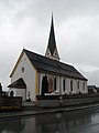
Roman Catholic church in Brandenberg, Tirol, Austria  | |||||
| Upload media | |||||
| Instance of | |||||
|---|---|---|---|---|---|
| Named after | |||||
| Location | Brandenberg, Kufstein District, Tyrol, Austria | ||||
| Street address |
| ||||
| Architectural style | |||||
| Heritage designation | |||||
 | |||||
| This category shows the protected monument with the number 122821 in Austria. (Commons, de, Wikidata) |
|
This category shows the remarkable cultural object in the Austrian state of Tyrol listed by the Tyrolean Art Cadastre with the ID
2245. (on tirisMaps, pdf, more images on Commons, Wikidata) |
Subcategories
This category has the following 2 subcategories, out of 2 total.
F
Media in category "Sankt Georg (Brandenberg, Tirol)"
The following 6 files are in this category, out of 6 total.
-
 Brandenberg St Georg8.jpg 2,848 × 5,000; 4.04 MB
-
 Brandenberg St Georg9 Kriegerdenkmal.jpg 5,456 × 3,632; 8.43 MB
-
 Brandenberg-KathPfarrkirche-HlGeorg.JPG 3,240 × 4,320; 2.9 MB
-
 St. Georg Brandenberg-1.jpg 4,240 × 3,590; 1.77 MB
-
 St. Georg Brandenberg-2.jpg 3,648 × 5,472; 1.5 MB
-
 St. Georg Brandenberg-3.jpg 3,648 × 5,472; 1.97 MB


