Category:Satellite pictures of Yellowstone National Park
Jump to navigation
Jump to search
United States national parks: Acadia · Badlands · Big Bend · Biscayne · Channel Islands · Death Valley · Denali · Everglades · Glacier Bay · Lake Clark · Olympic · Redwood · Rocky Mountain · White Sands · Yellowstone ·
Media in category "Satellite pictures of Yellowstone National Park"
The following 6 files are in this category, out of 6 total.
-
 Fire and the Future of Yellowstone - NASA Earth Observatory.jpg 720 × 964; 365 KB
-
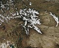 Snow in Grand Tetons and Yellowstone National Park (MODIS 2019-10-08).jpg 3,181 × 2,574; 2.88 MB
-
 Yellowstone by Sentinel-2, 2020-07-16 (big version).jpg 11,818 × 11,480; 189.55 MB
-
 Yellowstone by Sentinel-2, 2020-07-16 (small version).jpg 5,909 × 5,740; 48.99 MB
-
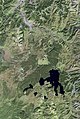 Yellowstone satellite map.jpg 597 × 891; 89 KB
-
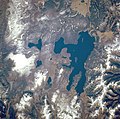 Yellowstone STS068-247-61.jpg 639 × 634; 85 KB

.jpg)
.jpg)
.jpg)

