Category:Satellite pictures of peninsulas
Jump to navigation
Jump to search
Subcategories
This category has the following 26 subcategories, out of 26 total.
Media in category "Satellite pictures of peninsulas"
The following 46 files are in this category, out of 46 total.
-
 Australia.A2010283.0435.250m.jpg 2,800 × 3,600; 2.88 MB
-
 Baie de Quiberon.png 770 × 713; 1.12 MB
-
 Baja La Paz (mexico) 250m.JPG 3,600 × 4,800; 1.5 MB
-
 Baja peninsula (mexico) 250m Sierra Giganta.jpg 3,600 × 4,800; 2.86 MB
-
 Baja peninsula (mexico) 250m.jpg 3,600 × 4,800; 1.71 MB
-
 Bang Kachao Landsat.jpg 720 × 480; 246 KB
-
 Bay Area by Sentinel-2, 2019-03-11 (big version).jpg 20,389 × 21,539; 487.33 MB
-
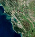 Bay Area by Sentinel-2, 2019-03-11 (small version).jpg 10,200 × 10,776; 123.14 MB
-
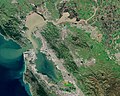
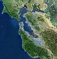 BayareaUSGS.jpg 769 × 798; 613 KB
-
 Bushfires on Eyre Peninsula, South Australia January 11 2005.jpg 828 × 851; 329 KB
-
 Cap Bon NASA.jpg 1,024 × 702; 148 KB
-
 Channel Islands viewed from ISS in 2012.JPG 2,832 × 4,256; 3.78 MB
-
 Dalian, China, satellite image, LandSat-5, 2010-08-03.jpg 3,062 × 2,852; 2.12 MB
-
 ESC large ISS014 ISS014-E-17038.JPG 3,032 × 2,008; 1.1 MB
-
 Eyre Peninsula Satellite NASA.jpg 1,713 × 1,478; 693 KB
-
 Florida night-time satellite image before-and-after Hurricane Irma.jpg 2,830 × 979; 160 KB
-
 Freycinet Peninsula NASA.jpg 1,024 × 702; 99 KB
-
 Grytviken-Location.jpg 2,165 × 1,516; 1.48 MB
-
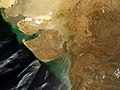 Gujarat satellite view.jpg 4,000 × 3,000; 1.35 MB
-
 Gulf of California.jpg 4,200 × 5,200; 2.95 MB
-
 Huon Peninsula NASA.jpg 1,024 × 702; 217 KB
-
 India 78.40398E 20.74980N.jpg 1,280 × 958; 167 KB
-
 Istra iz svemira 8bb0e723bf o.jpg 4,513 × 5,641; 5.19 MB
-
 Italian coast-satel.jpeg 1,020 × 676; 240 KB
-
 LANDSAT semenanjung malaysia - 2.jpg 5,392 × 5,680; 5.71 MB
-
 Leizhou peninsula.jpg 1,397 × 1,332; 517 KB
-
 LyngseidetNorway (cropped).jpg 3,747 × 1,265; 1.96 MB
-
 LyngseidetNorway.jpg 4,408 × 2,481; 4.99 MB
-
 Malaysia on satellite map (NASA World Wind).PNG 492 × 491; 211 KB
-
 Mar de China Meridional - BM WMS 2004.jpg 1,060 × 989; 251 KB
-
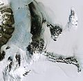 Mcmurdo (cropped).jpg 1,083 × 1,063; 837 KB
-
 NASA-Satellitenfoto Süd-Kuba, Guantanamo Bay.jpg 453 × 350; 50 KB
-
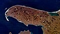
 Paria Peninsula NASA.jpg 1,024 × 702; 163 KB
-
 PortofinoDivingPoints.jpg 2,255 × 1,578; 870 KB
-
 Presentation1 1696666311.jpg 1,280 × 720; 143 KB
-
 Salvador Satellite.jpg 4,096 × 4,096; 16.58 MB
-
 Satellite image of Croatia in September 2003.jpg 2,172 × 2,100; 1.59 MB
-

-

-
 Satellite image of Kola Peninsula in June 2001.jpg 2,000 × 2,000; 893 KB
-
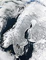 Scandinavia.TMO2003050.jpg 5,600 × 7,200; 7.42 MB
-
 SoudaBay-satpic2.png 844 × 664; 859 KB
-
 Stromness-Bay.jpg 1,792 × 1,104; 937 KB
-
 View of the Bay Area and the Californian Delta.jpg 6,034 × 4,838; 39.04 MB
-
 Песчаный полуостров.jpg 642 × 583; 58 KB
-
 Полуостров Михайлова.jpg 918 × 525; 119 KB


_250m.JPG)
_250m_Sierra_Giganta.jpg)
_250m.jpg)

.jpg)
.jpg)


.PNG)

.jpg)


.jpg)
.jpg)


.jpg)