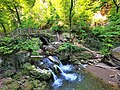
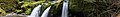
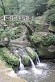
Category:Schéissendëmpel
Jump to navigation
Jump to search
| Object location | | View all coordinates using: OpenStreetMap |
|---|
,_Schiessent%C3%BCmpel_--_2015_--_6022_--_2.jpg) | |||||
| Upload media | |||||
| Instance of | |||||
|---|---|---|---|---|---|
| Location | Black Ernz | ||||
| Drainage basin |
| ||||
| Different from | |||||
 | |||||
Media in category "Schéissendëmpel"
The following 41 files are in this category, out of 41 total.
-
 04-05-31 Müllertal Lxb 01.JPG 2,048 × 1,536; 1.06 MB
-
 04-05-31 Müllertal Lxb 02.jpg 1,536 × 2,048; 974 KB
-
 06660-Luxemburg-1905-Schießentümpel - Müllerthal-Brück & Sohn Kunstverlag.jpg 1,000 × 1,557; 685 KB
-
 Catarata parque Mullerthal.jpg 5,184 × 3,456; 2.82 MB
-
 Ch Bernhoeft 1891 GD Luxembourg 07 Pl 1.4 Mullerthal Cascade.jpg 1,899 × 2,840; 2.56 MB
-
 Consdorf, Parking Mëllerdall.jpg 2,440 × 2,440; 2.6 MB
-
 Consdorf, Schiessentümpel (2633).jpg 660 × 424; 70 KB
-
 Consdorf, Schiessentümpel (2644).jpg 445 × 660; 79 KB
-
 Luxembourg road sign F,14a Schiessentumpel.jpg 2,444 × 2,444; 1.88 MB
-
 Luxembourg, Consdorf-Waldbillig. Schiessentümpel 2020 (101).jpg 3,557 × 2,669; 3.33 MB
-
 Luxembourg, Consdorf-Waldbillig. Schiessentümpel 2020 (102).jpg 5,119 × 3,839; 8.63 MB
-
 Luxembourg, Consdorf-Waldbillig. Schiessentümpel 2020 (103).jpg 3,648 × 2,736; 5.79 MB
-
 Luxembourg, Schéissendëmpel panneau (102).jpg 2,613 × 3,521; 885 KB
-
 Mullerthal Cascade Bridge 01.jpg 4,256 × 2,832; 17.01 MB
-
 Mullerthal Cascade Bridge 02.jpg 4,256 × 2,832; 9.45 MB
-
 Mullerthal Wikivoyage Banner.jpg 5,472 × 785; 2.65 MB
-
 Mullerthal, winter.jpg 1,536 × 2,048; 948 KB
-
 Mullerthal.jpg 1,712 × 2,288; 3.41 MB
-
 Müllerthal-Schiessentümpel.jpg 1,024 × 770; 784 KB
-
 Parque Mullerthal.jpg 3,456 × 5,184; 4.32 MB
-
 Schiessentumpel Waterfall (29069615).jpeg 2,048 × 1,356; 843 KB
-
 Schiessentumpel.jpg 2,592 × 1,944; 935 KB
-
 Schiessentümpel 11 08 2013.jpg 4,256 × 2,837; 7.56 MB
-
 Schiessentümpel.jpg 2,592 × 1,944; 921 KB
-
 Schiessentümpel.JPG 1,200 × 1,600; 944 KB
-
 Schiessentümpel2013.jpg 1,920 × 1,272; 983 KB
-
 Schissentümpel 2014 10 05.JPG 4,288 × 2,848; 3.01 MB
-
 Waldbillig (LU), Schiessentümpel -- 2015 -- 4508.jpg 5,184 × 3,456; 10.81 MB
-
 Waldbillig (LU), Schiessentümpel -- 2015 -- 4512.jpg 5,184 × 3,456; 12.05 MB
-
 Waldbillig (LU), Schiessentümpel -- 2015 -- 4515.jpg 5,184 × 3,456; 14.94 MB
-
 Waldbillig (LU), Schiessentümpel -- 2015 -- 6020.jpg 5,320 × 3,252; 12 MB
-
 Waldbillig (LU), Schiessentümpel -- 2015 -- 6022 -- 2.jpg 3,648 × 3,648; 9.22 MB
-
 Waldbillig (LU), Schiessentümpel -- 2015 -- 6022.jpg 5,472 × 3,648; 13.26 MB
-
 Waldbillig (LU), Schiessentümpel -- 2015 -- 6027 -- 2.jpg 3,505 × 3,505; 5.51 MB
-
 Waldbillig (LU), Schiessentümpel -- 2015 -- 6027 -- 3.jpg 3,505 × 3,505; 1.96 MB
-
 Waldbillig (LU), Schiessentümpel -- 2015 -- 6027.jpg 5,472 × 3,648; 9.67 MB
-
 Waldbillig (LU), Schiessentümpel -- 2015 -- 6033 -- 2.jpg 3,648 × 3,648; 8.32 MB
-
 Waldbillig (LU), Schiessentümpel -- 2015 -- 6033 -- 3.jpg 3,648 × 3,648; 12.66 MB
-
 Waldbillig (LU), Schiessentümpel -- 2015 -- 6033.jpg 5,045 × 3,648; 12.45 MB
-
 Waldbillig (LU), Schiessentümpel -- 2015 -- 6034.jpg 5,472 × 3,648; 10.89 MB
-
 Wasserfälle -- 2017.jpg 7,087 × 4,724; 4.53 MB


.jpg)
.jpg)

.jpg)
.jpg)
.jpg)
.jpg)


.jpeg)


,_Schiessent%C3%BCmpel_--_2015_--_4508.jpg)
,_Schiessent%C3%BCmpel_--_2015_--_4512.jpg)
,_Schiessent%C3%BCmpel_--_2015_--_4515.jpg)
,_Schiessent%C3%BCmpel_--_2015_--_6020.jpg)
,_Schiessent%C3%BCmpel_--_2015_--_6022.jpg)
,_Schiessent%C3%BCmpel_--_2015_--_6027_--_2.jpg)
,_Schiessent%C3%BCmpel_--_2015_--_6027_--_3.jpg)
,_Schiessent%C3%BCmpel_--_2015_--_6027.jpg)
,_Schiessent%C3%BCmpel_--_2015_--_6033_--_2.jpg)
,_Schiessent%C3%BCmpel_--_2015_--_6033_--_3.jpg)
,_Schiessent%C3%BCmpel_--_2015_--_6033.jpg)
,_Schiessent%C3%BCmpel_--_2015_--_6034.jpg)
