Category:Schloss Brunegg (Kreuzlingen)
Jump to navigation
Jump to search
| Object location | | View all coordinates using: OpenStreetMap |
|---|
|
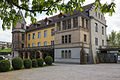
This is a category about a cultural property of regional significance in Switzerland with KGS number 11018
|
castle  | |||||
| Upload media | |||||
| Instance of | |||||
|---|---|---|---|---|---|
| Part of | |||||
| Location |
| ||||
| Street address |
| ||||
| Heritage designation | |||||
 | |||||
Media in category "Schloss Brunegg (Kreuzlingen)"
The following 10 files are in this category, out of 10 total.
-
 BruneggKreuzlingen.jpg 2,972 × 2,376; 5.44 MB
-
 KreuzlingenBrunegg.jpg 1,754 × 1,029; 1.21 MB
-
 KreuzlingenBruneggSepia.jpg 1,754 × 1,029; 1.11 MB
-
 KreuzlingnBruneggWest.jpg 1,080 × 1,621; 1.27 MB
-
 KreuzlngnBruneggArkaden.jpg 1,838 × 1,011; 1.37 MB
-
 KreuzlngnBruneggTurmNordOst.jpg 1,036 × 1,780; 1.05 MB
-
 Schloss Brunegg (Nordwestansicht).jpg 3,000 × 2,000; 4.76 MB
-
 Schloss Brunegg in Kreuzlingen.jpg 4,000 × 3,000; 9.17 MB
-
 Schloss Brunegg, Kreuzlingen.jpg 3,840 × 2,880; 8.13 MB
-
 SchlossBrunegg.JPG 1,600 × 1,200; 704 KB


.jpg)

