Category:Schloss Kannawurf
Jump to navigation
Jump to search
| Object location | | View all coordinates using: OpenStreetMap |
|---|
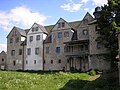
building in Kannawurf (Germany)  | |||||
| Upload media | |||||
| Instance of | |||||
|---|---|---|---|---|---|
| Location | Kannawurf, Kindelbrück, Landkreis Sömmerda, Thuringia, Germany | ||||
| Heritage designation | |||||
 | |||||
Media in category "Schloss Kannawurf"
The following 9 files are in this category, out of 9 total.
-
 Kannawurf Schloss 01.jpg 4,000 × 2,312; 2.92 MB
-
 Kannawurf Schloss 02.jpg 3,648 × 2,736; 2.34 MB
-
 Kannawurf Schloss 03.jpg 3,648 × 2,736; 1.89 MB
-
 Kannawurf Schloss 04.jpg 3,648 × 2,736; 1.87 MB
-
 Kannawurf Schloss 05.jpg 3,848 × 3,400; 2.49 MB
-
 Kannawurf Schloss 06.jpg 5,232 × 1,048; 1.63 MB
-
 Schloss Kannawurf.JPG 1,600 × 1,200; 447 KB
-
 Schloss Kannawurf2.JPG 1,600 × 1,200; 392 KB
-
 Uhrwerk Schlossturm Kannawurf.JPG 1,600 × 1,200; 388 KB


