Category:Sea wall, Albert Dock, Liverpool
Jump to navigation
Jump to search
| Object location | | View all coordinates using: OpenStreetMap |
|---|
This is a category about listed building number 1068411. |
wall in Liverpool, Merseyside, UK  | |||||
| Upload media | |||||
| Instance of | |||||
|---|---|---|---|---|---|
| Location | Liverpool, Merseyside, North West England, England | ||||
| Heritage designation |
| ||||
 | |||||
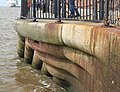
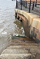
"Wall. c.1846. J Hartley.Granite.Runs for approx. 330 metres from Albert Pierhead to Gower Street. 2 sets of stone steps, one at south end and one halfway along parade; wall rounded and corbelled out in a series of curves to recesses for steps." (Historic England listing).
Media in category "Sea wall, Albert Dock, Liverpool"
The following 3 files are in this category, out of 3 total.
-
 Sea wall, Albert Dock 1.jpg 4,392 × 3,360; 10.79 MB
-
 Sea wall, Albert Dock 2.jpg 3,456 × 4,336; 11.36 MB
-
 Sea wall, Albert Dock 3.jpg 3,412 × 5,054; 14.08 MB

