Category:Seil, Scotland
Zur Navigation springen
Zur Suche springen
Insel in Schottland   | |||||
| Medium hochladen | |||||
| Ist ein(e) | |||||
|---|---|---|---|---|---|
| Ist Teil von | |||||
| Ort |
| ||||
| Liegt am oder im Gewässer | |||||
| Einwohnerzahl |
| ||||
| Fläche |
| ||||
 | |||||
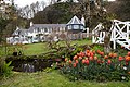
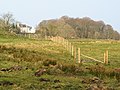
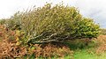
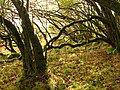
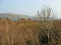
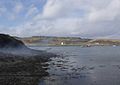
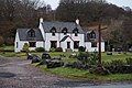
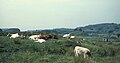
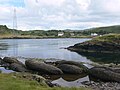
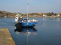
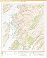
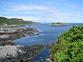
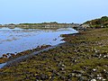
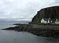
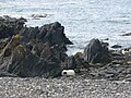
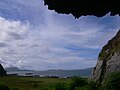
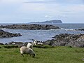
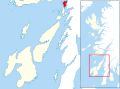
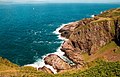
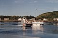
Seil (Scottish Gaelic: Saoil) is small island on the east side of the Firth of Lorn, 11 km southwest of Oban, in Scotland. It is one of the Slate Islands.
Unterkategorien
Es werden 6 von insgesamt 6 Unterkategorien in dieser Kategorie angezeigt:
In Klammern die Anzahl der enthaltenen Kategorien (K), Seiten (S), Dateien (D)
C
- Clachan Bridge (85 D)
K
- Kilbrandon Church (38 D)
S
T
- Tigh an Truish Inn (23 D)
- Tin Church, Seil (2 D)
Medien in der Kategorie „Seil, Scotland“
Folgende 138 Dateien sind in dieser Kategorie, von 138 insgesamt.
-
 'Innish' B^B at Clachan Bridge - geograph.org.uk - 4511990.jpg 3.264 × 2.448; 4,62 MB
-
 Admiralty Chart No 2063 Scotland - west coast - Easdale Sound, Published 1851.jpg 3.766 × 4.611; 3,73 MB
-
 Admiralty Chart No 2326 Loch Crinan to the Firth of Lorne (5413X8102), Published 1959.jpg 5.413 × 8.102; 14,28 MB
-
 Admiralty Chart No 2326 Loch Crinan to the Firth of Lorne, Published 1959.jpg 6.774 × 9.906; 25,95 MB
-
 Admiralty Chart No 2476 Frith of Lorn, Published 1856.jpg 8.269 × 14.016; 16,45 MB
-
 Admiralty Chart No 2476 Frith of Lorn, Published 1910.jpg 8.132 × 14.033; 12,28 MB
-
 An Cala, Seil (21762515544).jpg 5.472 × 3.648; 3,38 MB
-
 An Cala, Seil (21762529624).jpg 5.397 × 3.598; 6,46 MB
-
 An Cala, Seil (22197285920).jpg 5.472 × 3.648; 7,98 MB
-
 An Cala, Seil (22197291860).jpg 3.648 × 5.472; 8,46 MB
-
 An Cala, Seil (22372143952).jpg 3.647 × 3.647; 2,37 MB
-
 An Cala, Seil (22372149812).jpg 3.648 × 5.472; 6,94 MB
-
 An Cala, Seil (22396037071).jpg 5.472 × 3.648; 6,89 MB
-
 Ardea cinerea in Seil 01.JPG 3.264 × 2.448; 1,22 MB
-
 Ardea cinerea in Seil 02.JPG 3.264 × 2.448; 1,11 MB
-
 Ardencaple House, Isle of Seil - geograph.org.uk - 385544.jpg 640 × 479; 131 KB
-
 Ardencaple, Seil Island - 1971 - geograph.org.uk - 2950137.jpg 2.272 × 1.514; 485 KB
-
 Ardencaple, Seil Island - 1971 - geograph.org.uk - 2950701.jpg 2.272 × 1.515; 304 KB
-
 B844 at Oban Seil, Isle of Seil - geograph.org.uk - 5214533.jpg 1.600 × 1.065; 660 KB
-
 Ballachuan 060.JPG 2.816 × 1.584; 2,08 MB
-
 Ballachuan Loch - geograph.org.uk - 385903.jpg 640 × 477; 94 KB
-
 Ballachuan survey 011.JPG 2.272 × 1.704; 2,12 MB
-
 Ballachuan Wood - geograph.org.uk - 385836.jpg 640 × 479; 136 KB
-
 Balvicar Bay - geograph.org.uk - 110586.jpg 640 × 454; 42 KB
-
 Balvicar Bay - geograph.org.uk - 19584.jpg 640 × 425; 89 KB
-
 Barnafeochaig.jpg 3.264 × 2.448; 1,43 MB
-
 Bench in Seil.JPG 3.264 × 2.448; 1,33 MB
-
 Clachan Sound 01.JPG 3.143 × 2.357; 4,55 MB
-
 Clachan Sound 02.JPG 3.009 × 2.256; 4,96 MB
-
 Clachan Sound 03.JPG 3.264 × 2.448; 1,39 MB
-
 Clachan Sound 04.JPG 3.264 × 2.448; 1,34 MB
-
 Clachan Sound 05.JPG 3.264 × 2.448; 1,24 MB
-
 Cuan Ferry - geograph.org.uk - 1034905.jpg 640 × 427; 67 KB
-
 Cuan Ferry - geograph.org.uk - 1036126.jpg 640 × 427; 62 KB
-
 Cuan Ferry, Seil (geograph 5468155).jpg 1.024 × 768; 226 KB
-
 Easdale from the road.JPG 3.157 × 2.368; 3,67 MB
-
 Easdale, Seil, Scotland (352084684).jpg 1.600 × 1.200; 577 KB
-
 Ellenabeich - geograph.org.uk - 95384.jpg 640 × 426; 115 KB
-
 Ferry slipway, Cuan Sound - geograph.org.uk - 733226.jpg 640 × 406; 75 KB
-
 Henderson's Rock - geograph.org.uk - 4167842.jpg 640 × 480; 421 KB
-
 Henderson's Rock - geograph.org.uk - 4167847.jpg 640 × 480; 467 KB
-
 Henderson's Rocks, Seil - geograph.org.uk - 290860.jpg 640 × 480; 69 KB
-
 In Nish, Clachan - geograph.org.uk - 5214122.jpg 1.600 × 1.065; 610 KB
-
 Innish from the 'Bridge over the Atlantic' - geograph.org.uk - 5403331.jpg 3.912 × 2.220; 1,02 MB
-
 Island of Seil, 1955 (1).jpg 3.123 × 1.395; 557 KB
-
 Island of Seil, 1955 (2).jpg 3.052 × 2.036; 1,05 MB
-
 Island of Seil, 1955 (3).jpg 2.984 × 2.048; 702 KB
-
 Island of Seil, 1955 (4).jpg 2.988 × 1.200; 484 KB
-
 Island of Seil, 1955 (5).jpg 3.136 × 2.113; 1,35 MB
-
 Island of Seil, 1955 (6).jpg 2.600 × 1.372; 521 KB
-
 Island of Seil, 1955 (7).jpg 3.084 × 2.016; 685 KB
-
 Island of Seil, 1955 (8).jpg 3.016 × 2.094; 1,23 MB
-
 Island of Seil, 1955 (9).jpg 3.095 × 1.615; 759 KB
-
 Isle of Seil - Slates with pyrite 01.JPG 3.264 × 2.448; 1,25 MB
-
 Isle of Seil - Slates with pyrite 02.JPG 3.264 × 2.448; 1,24 MB
-
 Isle of Seil - Slates with pyrite 03.JPG 3.264 × 2.448; 1,21 MB
-
 Isle of Seil - Slates with pyrite 04.JPG 3.264 × 2.448; 1,37 MB
-
 Isle of Seil 01.JPG 3.264 × 2.448; 1,42 MB
-
 Isle of Seil 02.JPG 3.264 × 2.448; 1,45 MB
-
 Isle of Seil 03.JPG 3.264 × 2.448; 1,16 MB
-
 Isle of Seil 04.JPG 3.264 × 2.448; 1,44 MB
-
 Isle of Seil 05.JPG 3.264 × 2.448; 1,16 MB
-
 Isle of Seil 06.JPG 3.264 × 2.448; 1,34 MB
-
 Isle of Seil 07.JPG 3.264 × 2.448; 1,41 MB
-
 Isle of Seil 08.JPG 3.264 × 2.448; 1,17 MB
-
 Luing - rocks and Seil.JPG 3.121 × 2.341; 4,37 MB
-
 Luing - sound between Luing and Seil.JPG 3.264 × 2.448; 1,27 MB
-
 Luing Ferry - geograph.org.uk - 168769.jpg 640 × 480; 194 KB
-
 Luing Ferry.jpg 640 × 476; 94 KB
-
 Luing from Seil.JPG 3.264 × 2.448; 1,31 MB
-
 Luing island from Seil island.JPG 3.264 × 2.448; 1,31 MB
-
 Maria Gastineau Part of island of Seil, Ben More in distance.jpg 500 × 329; 44 KB
-
 Meall a' Chaise - geograph.org.uk - 95390.jpg 640 × 424; 68 KB
-
 Nuagesryio.jpg 3.676 × 1.681; 2,84 MB
-
 Ordnance Survey One-inch Sheet 52 Loch Awe, Published 1956.jpg 8.604 × 10.703; 19,42 MB
-
 Ordnance Survey One-Inch Sheet 60 North Jura and Firth of Lorne, Published 1925.jpg 8.823 × 14.239; 11,94 MB
-
 Port a Mhuilinn - geograph.org.uk - 688.jpg 640 × 262; 22 KB
-
 Port a' Mhuilinn - geograph.org.uk - 4167977.jpg 640 × 480; 410 KB
-
 Port a' Mhuilinn - geograph.org.uk - 4471883.jpg 4.793 × 3.195; 5,17 MB
-
 Port a' Mhuilinn - geograph.org.uk - 4678277.jpg 1.600 × 1.200; 540 KB
-
 Port a'Mhuilinn, Seil - geograph.org.uk - 5468084.jpg 1.024 × 768; 235 KB
-
 Puilladobhrain Anchorage - geograph.org.uk - 4167808.jpg 640 × 480; 487 KB
-
 Puilladobhrain Anchorage - geograph.org.uk - 6213272.jpg 1.024 × 576; 85 KB
-
 Quay, Cuan - geograph.org.uk - 529472.jpg 640 × 480; 87 KB
-
 Rock outcrop on beach at Port a' Mhuilinn - geograph.org.uk - 4471909.jpg 4.697 × 2.905; 4,09 MB
-
-
 Scotland - Isle of Seil 01.JPG 3.264 × 2.448; 1,24 MB
-
 Scotland - Isle of Seil 02.JPG 3.264 × 2.448; 1,27 MB
-
 Scotland - Isle of Seil 03.JPG 3.264 × 2.448; 1,51 MB
-
 Scotland - Isle of Seil 04.JPG 2.448 × 3.264; 1,37 MB
-
 Scotland - Isle of Seil 05.JPG 3.264 × 2.448; 1,25 MB
-
 Scotland - Isle of Seil 06.JPG 3.264 × 2.448; 1,45 MB
-
 Scotland - Isle of Seil 07.JPG 3.264 × 2.448; 1,39 MB
-
 Scotland - Isle of Seil 08.JPG 3.264 × 2.448; 1,23 MB
-
 Scotland - Isle of Seil 09.JPG 2.448 × 3.264; 1,26 MB
-
 Scotland - Isle of Seil 10.JPG 3.264 × 2.448; 1,29 MB
-
 Scotland - Isle of Seil 11.JPG 3.264 × 2.448; 1,38 MB
-
 Scotland - Isle of Seil 12.JPG 3.264 × 2.448; 1,23 MB
-
 Scotland - Seil - cave.JPG 3.264 × 2.448; 1,31 MB
-
 Scotland - Seil 01.JPG 3.264 × 2.448; 1,38 MB
-
 Scotland - Seil 02.JPG 3.264 × 2.448; 1,32 MB
-
 Scotland - Seil 04.JPG 3.264 × 2.448; 1,2 MB
-
 Scotland - Seil 05.JPG 3.264 × 2.448; 1,29 MB
-
 Scotland - Seil 06.JPG 3.264 × 2.448; 1,23 MB
-
 Scotland - Seil 07.JPG 3.264 × 2.448; 1,28 MB
-
 Scotland - Seil 08.JPG 3.264 × 2.448; 1,56 MB
-
 Scotland - Seil 09.JPG 3.264 × 2.448; 1,4 MB
-
 Scotland - Seil 10.JPG 3.264 × 2.448; 1,35 MB
-
 Scotland - Seil 11.JPG 3.264 × 2.448; 1,37 MB
-
 Seil - abandonned sign.JPG 3.264 × 2.448; 1,31 MB
-
 Seil - Ballachuan Loch.JPG 3.264 × 2.448; 1,25 MB
-
 Seil - beach.JPG 3.190 × 2.393; 3,63 MB
-
 Seil - Lattice steel pylon.JPG 3.264 × 2.448; 1,22 MB
-
 Seil - pyrite cubes 01.JPG 3.264 × 2.448; 1,28 MB
-
 Seil - pyrite cubes 02.JPG 3.264 × 2.448; 1,26 MB
-
 Seil - pyrite cubes 03.JPG 3.264 × 2.448; 1,2 MB
-
 Seil - pyrite cubes 04.JPG 3.264 × 2.448; 1,37 MB
-
 Seil - pyrite cubes 05.JPG 3.264 × 2.448; 1,36 MB
-
 Seil - quarry at Easdale.JPG 3.264 × 2.448; 1,23 MB
-
 Seil - to Easdale.JPG 2.644 × 1.983; 2,82 MB
-
 Seil - to the West.JPG 3.264 × 2.448; 1,31 MB
-
 Seil - West coast.JPG 3.264 × 2.448; 1,34 MB
-
 Seil and Luing islands.JPG 3.264 × 2.448; 1,42 MB
-
 Seil in Southern Argyll.svg 885 × 655; 3,56 MB
-
 Seil off Oban, Argyllshire.svg 311 × 371; 4,27 MB
-
 Seil seen from Luing.JPG 3.264 × 2.448; 1,44 MB
-
 Seill.jpg 640 × 480; 69 KB
-
 Semi-open top bus approaching Easdale - geograph.org.uk - 2086098.jpg 640 × 425; 304 KB
-
 Siel 27998.jpg 3.200 × 1.771; 1,39 MB
-
 Sloc Nan Uan - geograph.org.uk - 95127.jpg 640 × 411; 114 KB
-
 South from Seil - geograph.org.uk - 22306.jpg 640 × 480; 92 KB
-
 Steep climb at Kilbride - geograph.org.uk - 5929988.jpg 1.024 × 768; 116 KB
-
 Sunrise over Seil - geograph.org.uk - 1129272.jpg 640 × 480; 72 KB
-
 Symmetry (35917422852).jpg 3.543 × 2.446; 7,79 MB
-
 The Cuan ferry at Luing - geograph.org.uk - 1509263.jpg 640 × 426; 228 KB
-
-
 West coast of Seil - geograph.org.uk - 4167941.jpg 640 × 480; 486 KB
-
 Whitewashed cottages at Ellenabeich - geograph.org.uk - 158872.jpg 640 × 427; 52 KB


,_Published_1959.jpg)


.jpg)
.jpg)
.jpg)
.jpg)
.jpg)
.jpg)
.jpg)


.jpg)

.jpg)


.jpg)
.jpg)
.jpg)
.jpg)
.jpg)
.jpg)
.jpg)
.jpg)


.jpg)


.jpg)