Category:Shepperd's Dell Bridge
Jump to navigation
Jump to search
This category is intended for media related to Shepperds Dell Bridge (Young Creek Bridge), Multnomah County, Oregon, United States.
| Object location | | View all coordinates using: OpenStreetMap |
|---|
.png)
Subcategories
This category has only the following subcategory.
H
Media in category "Shepperd's Dell Bridge"
The following 16 files are in this category, out of 16 total.
-
 374 Shepperds Dell CRH by C&D (22475984116).jpg 2,014 × 3,176; 3 MB
-
 375 Shepperd's Dell Bridge CRH by C&D (22501966425).jpg 3,223 × 2,035; 2.96 MB
-

-

-
 Columbia River Gorge (8237582915).jpg 2,880 × 2,160; 1.61 MB
-
 Columbia River Highway at Shepperds Dell 2007.03.17.png 640 × 480; 624 KB
-

-
 HAER HCRH OR-36-26.jpg 5,000 × 3,976; 2.05 MB
-
 Shepherds Dell bridge over Youngs Creek (3387859822).jpg 3,279 × 4,246; 1.93 MB
-
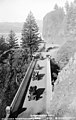
 Shepperd's Dell Bridge (1914).jpg 2,310 × 1,815; 361 KB
-
 Shepperd's Dell Bridge (2012-05-20).jpg 3,264 × 2,448; 3.01 MB
-
 Shepperd's Dell Bridge (cropped HAER measured drawing).png 4,104 × 4,104; 102 KB
-
 Shepperd's Dell Bridge CRH by Gifford (22314097670).jpg 1,859 × 3,241; 4.4 MB
-
 Shepperd's Dell CRH (21880843563).jpg 3,085 × 1,909; 2.75 MB
-
 Shepperd's Dell, Columbia River Highway, Oregon (75488).jpg 3,309 × 2,079; 3.28 MB
-
 Shepperds Dell Bridge - HCRH Oregon.jpg 2,304 × 3,072; 1.43 MB
.jpg)
.jpg)
.jpg)
.jpg)
.jpg)


.jpg)
.jpg)
.jpg)
.jpg)
.jpg)
.jpg)
