Category:Siegesturm Bayreuth
Jump to navigation
Jump to search
| Object location | | View all coordinates using: OpenStreetMap |
|---|
cultural heritage monument D-4-62-000-483 (0) in Bayreuth, Bavaria  | |||||
| Upload media | |||||
| Instance of | |||||
|---|---|---|---|---|---|
| Made from material | |||||
| Location | Bayreuth, Upper Franconia, Bavaria, Germany | ||||
| Street address |
| ||||
| Heritage designation | |||||
| Height |
| ||||
 | |||||
This is the category of the Bavarian Baudenkmal (cultural heritage monument) with the ID D-4-62-000-483 (Wikidata)
|
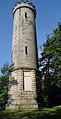
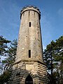
Deutsch: Der 1874 errichtete Siegesturm auf der Hohen Warte nördlich von Bayreuth. Sechseckiger hoher Sockel mit Plattenrustika, darüber runder Turm mit abschließendem Zinnenkranz, Sandstein, Inschriftentafeln, 1872-74 zum Gedächtnis der deutschen Siege von 1870/71, von Carl Wölfel und Hans Weiß. Nicht zu verwechseln mit dem süd-westlich der Kernstadt gelegenen Siegesturm bei Eckersdorf.
English: The Siegesturm (=victory tower) was built in 1874 on the hill Hohe Warte, northerly of Bayreuth. Not to be confused with the other Siegesturm in the area.
Subcategories
This category has only the following subcategory.
V
Media in category "Siegesturm Bayreuth"
The following 5 files are in this category, out of 5 total.
-
 Bayreuth 13.09.07 Siegesturm Hohe Warte.jpg 1,033 × 2,016; 635 KB
-
 Siegesturm - panoramio.jpg 1,200 × 1,600; 336 KB
-
 Siegesturm Bayreuth, Inscription.jpg 2,150 × 4,300; 7.41 MB
-
 Siegesturm.jpg 1,200 × 1,600; 521 KB
-
 BASA-3K-7-359-66-Tower.jpg 3,209 × 2,385; 1.24 MB


Categories:
- Cultural heritage monuments in Bayreuth
- Buildings in Bayreuth
- Hohe Warte (Bayreuth)
- Observation towers in Upper Franconia
- Hans Weiß (architect)
- Built in Bavaria in 1874
- Stone towers in Bavaria
- Sandstone buildings in Upper Franconia
- Round towers in Bavaria
- Franco-Prussian War memorials in Bayreuth
- 17-meter-tall buildings in Germany