Category:Silokerk (Utrecht)
Jump to navigation
Jump to search
| Object location | | View all coordinates using: OpenStreetMap |
|---|
church in Utrecht, Netherlands  | |||||
| Upload media | |||||
| Instance of | |||||
|---|---|---|---|---|---|
| Location | Utrecht, Netherlands | ||||
 | |||||
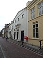
Nederlands: Utrecht, Herenstraat 34-36 - Silokerk - anno 1821 - Voormalige schuilkerk
Media in category "Silokerk (Utrecht)"
The following 2 files are in this category, out of 2 total.
-
 B-G Silo Utrecht.jpg 3,000 × 4,000; 3.14 MB
-

