Category:Sint-Amandus en Sint-Luciakerk (Markegem)
Jump to navigation
Jump to search
| Object location | | View all coordinates using: OpenStreetMap |
|---|
|
This is a category about onroerend erfgoed number 84429
|
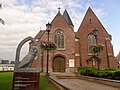
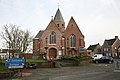
church in Markegem, Belgium  | |||||
| Upload media | |||||
| Instance of | |||||
|---|---|---|---|---|---|
| Dedicated to | |||||
| Location | Markegem, Dentergem, Arrondissement of Tielt, West Flanders, Flemish Region, Belgium | ||||
| Diocese | |||||
 | |||||
Media in category "Sint-Amandus en Sint-Luciakerk (Markegem)"
The following 8 files are in this category, out of 8 total.
-
 Gedenkplaat slachtoffers in dienst van Napoleon - Markegem.jpg 2,665 × 1,812; 1.22 MB
-
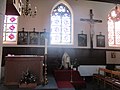
 Heilig Kruisbeeld - Markegem - 2016.jpg 2,736 × 3,648; 3.52 MB
-
 HH Amandus- en Luciakerk, Markegem.jpg 2,560 × 1,920; 2.12 MB
-
 Kerk van Markegem - België.jpg 1,245 × 741; 434 KB
-
 Markegem kerk.jpg 4,368 × 2,912; 3.72 MB
-
 Sint-Amandus en Sint-Luciakerk - Markegem 2023-01.jpg 5,152 × 3,864; 5.17 MB
-
 Sint-Amandus en Sint-Luciakerk - Markegem 2023-02.jpg 5,152 × 3,864; 4.59 MB
-
 Sint-Amandus- en Sint-Luciakerk - Markegem - 2023.jpg 5,140 × 1,656; 2.53 MB


Categories:
- Churches in Belgium by name
- Markegem
- Onroerend erfgoed in Dentergem
- Churches in Dentergem
- 13th-century churches in West Flanders
- 14th-century churches in West Flanders
- Brick Gothic churches in West Flanders
- Hall churches in West Flanders
- Saint Amandus churches in Belgium
- Saint Lucy churches in Belgium
- Churches dedicated to multiple saints