Category:Sint Janstraat 7, Breda
Jump to navigation
Jump to search
| Object location | | View all coordinates using: OpenStreetMap |
|---|
 | |||||
| Upload media | |||||
| Instance of |
| ||||
|---|---|---|---|---|---|
| Location | Breda, North Brabant, Netherlands | ||||
| Street address |
| ||||
| Located on street | |||||
| Heritage designation |
| ||||
 | |||||
|
This is a category about rijksmonument number 10220
|
| Address |
|
Media in category "Sint Janstraat 7, Breda"
The following 7 files are in this category, out of 7 total.
-
 Aanzicht - Breda - 20041282 - RCE.jpg 961 × 1,200; 229 KB
-
 Overzicht - Breda - 20041281 - RCE.jpg 827 × 1,200; 215 KB
-
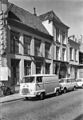
 Overzicht straat - Breda - 20397235 - RCE.jpg 1,200 × 961; 246 KB
-
 RM10220 Breda - St. Janstraat 7.jpg 1,944 × 2,592; 1.1 MB
-
 Voorgevel - Breda - 20041285 - RCE.jpg 947 × 1,200; 220 KB
-
 Voorgevel - Breda - 20041286 - RCE.jpg 966 × 1,200; 214 KB
-
 Voorgevels - Breda - 20041284 - RCE.jpg 822 × 1,200; 193 KB


