Category:Skerryvore
Jump to navigation
Jump to search
| Object location | | View all coordinates using: OpenStreetMap |
|---|
English: Skerryvore
remote reef off the west coast of Scotland, south-west of the island of Tiree  | |||||
| Upload media | |||||
| Instance of | |||||
|---|---|---|---|---|---|
| Part of | |||||
| Location |
| ||||
| Located in or next to body of water | |||||
| Width |
| ||||
| Length |
| ||||
| Population |
| ||||
 | |||||
Media in category "Skerryvore"
The following 7 files are in this category, out of 7 total.
-
 Hynish signal.jpg 422 × 596; 213 KB
-
 Hynish, Isle of Tiree - Pier - geograph.org.uk - 89483.jpg 640 × 480; 110 KB
-
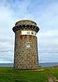
 Skerryvore lighthouse - former barracks (geograph 6888669).jpg 1,372 × 1,000; 876 KB
-

-
 Skerryvore, Costa del Folk, Portugal, October 2016 (30141292442).jpg 4,530 × 3,020; 1.47 MB
-
 Skerryvore, Costa del Folk, Portugal, October 2016 (30171149361).jpg 4,530 × 3,020; 841 KB
-
 Westbourne, Skerryvore lighthouse replica - geograph.org.uk - 483862.jpg 429 × 640; 126 KB


.jpg)

.jpg)
.jpg)
