Category:Slotweg 7, Halsteren
Jump to navigation
Jump to search
| Object location | | View all coordinates using: OpenStreetMap |
|---|
farmhouse in Bergen op Zoom, Netherlands  | |||||
| Upload media | |||||
| Instance of | |||||
|---|---|---|---|---|---|
| Location | Lepelstraat, Bergen op Zoom, North Brabant, Netherlands | ||||
| Street address |
| ||||
| Heritage designation |
| ||||
 | |||||
|
This is a category about rijksmonument number 19996
|
| Address |
|
Subcategories
This category has only the following subcategory.
I
- Interior of Slotweg 7, Halsteren (15 F)
Media in category "Slotweg 7, Halsteren"
The following 23 files are in this category, out of 23 total.
-

-

-
 Halsteren - Slotweg 7 - Hoeve 't Slot.JPG 4,723 × 2,086; 3.08 MB
-
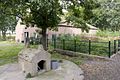 Hondenhok op het erf - Lepelstraat - 20411839 - RCE.jpg 1,200 × 800; 311 KB
-
 Ligging van de boerderij in haar omgeving - Lepelstraat - 20411843 - RCE.jpg 1,200 × 800; 230 KB
-
 Ligging van de boerderij in haar omgeving - Lepelstraat - 20411844 - RCE.jpg 1,200 × 800; 323 KB
-
 Linker zijgevel van boerderij - Lepelstraat - 20411840 - RCE.jpg 1,200 × 800; 302 KB
-
 Linker zijgevel van stal - Lepelstraat - 20411837 - RCE.jpg 1,200 × 800; 222 KB
-

-
 Overzicht achtergevel voormalig varkensschuur - Lepelstraat - 20411833 - RCE.jpg 1,200 × 800; 251 KB
-

-

-
 Overzicht van de omgeving - Lepelstraat - 20411841 - RCE.jpg 1,200 × 800; 236 KB
-
 Overzicht van de omgeving - Lepelstraat - 20411845 - RCE.jpg 1,200 × 800; 279 KB
-
 Overzicht van de omgeving - Lepelstraat - 20411846 - RCE.jpg 1,200 × 800; 245 KB
-
 Overzicht voorgevel van boerderij - Lepelstraat - 20411419 - RCE.jpg 1,200 × 800; 245 KB
-
 Rechter zijgevel boerderij - Lepelstraat - 20411820 - RCE.jpg 1,200 × 800; 152 KB
-
 Rechter zijgevel van boerderij met schuurtje - Lepelstraat - 20411916 - RCE.jpg 1,200 × 800; 254 KB
-
 Stal met ommuring erf - Lepelstraat - 20411824 - RCE.jpg 1,200 × 800; 243 KB
-
 Voorgevel en rechter zijgevel van schuurtje - Lepelstraat - 20411917 - RCE.jpg 1,200 × 800; 243 KB
-

-

-


