Category:South Holm of Burravoe
Jump to navigation
Jump to search
| Object location | | View all coordinates using: OpenStreetMap |
|---|
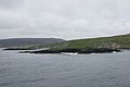
English: South Holm of Burravoe: a small isle off the eastern coast of North Roe region of Northmavine, Mainland, Shetland. Lies within Yell Sound.
islet off the east of Northmavine, Mainland, Shetland Islands, Scotland, UK .jpg) | |||||
| Upload media | |||||
| Instance of | |||||
|---|---|---|---|---|---|
| Location | Shetland Islands, Scotland | ||||
 | |||||
Media in category "South Holm of Burravoe"
The following 2 files are in this category, out of 2 total.
-
 Holms of Burravoe (geograph 1927671).jpg 800 × 533; 116 KB
-
 South Holm of Burravoe (geograph 1927657).jpg 640 × 426; 43 KB
.jpg)