Category:St Arvans
Jump to navigation
Jump to search
village and community in Monmouthshire, Wales  Eglwys Sant Arfan, Llanarfan | |||||
| Upload media | |||||
| Pronunciation audio | |||||
|---|---|---|---|---|---|
| Instance of | |||||
| Location | Monmouthshire, Wales | ||||
 | |||||
St. Arvans, just North of Chepstow up the Wye valley.
Subcategories
This category has the following 4 subcategories, out of 4 total.
Media in category "St Arvans"
The following 200 files are in this category, out of 242 total.
(previous page) (next page)-
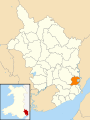 2010 Wales Monmouthshire Community St Arvans map.svg 512 × 682; 699 KB
-
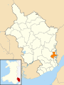 2024 Wales Monmouthshire Community St Arvans map.svg 512 × 682; 603 KB
-
 466 at Lower Wyndcliff Wood - geograph.org.uk - 3792940.jpg 640 × 480; 94 KB
-

-
 A lane near Wyndcliffe Court - geograph.org.uk - 5150453.jpg 2,592 × 1,944; 1.62 MB
-
 A picnic table with a view - geograph.org.uk - 2673675.jpg 640 × 480; 132 KB
-

-
 A466 bend near Liveoaks Grove - geograph.org.uk - 3792941.jpg 640 × 481; 70 KB
-
 A466 direction sign near St Arvans - geograph.org.uk - 5193136.jpg 800 × 651; 136 KB
-
 A466 distances from St Arvans - geograph.org.uk - 5193439.jpg 800 × 785; 163 KB
-
 A466 east of St Arvans - geograph.org.uk - 3792938.jpg 640 × 480; 72 KB
-
 A466 from Chepstow reaches St Arvans - geograph.org.uk - 2710983.jpg 640 × 486; 98 KB
-

-
 A466 near Chepstow Racecourse - geograph.org.uk - 3792931.jpg 640 × 481; 64 KB
-
 A466 nears St Arvans - geograph.org.uk - 3792936.jpg 640 × 481; 68 KB
-
 A466 roadworks in Lower Wyndcliff Wood - geograph.org.uk - 5588934.jpg 1,600 × 1,200; 775 KB
-
 A466 St Lawrence Road - geograph.org.uk - 3792928.jpg 640 × 481; 79 KB
-

-
 An empty Chepstow Racecourse - geograph.org.uk - 2748258.jpg 640 × 480; 41 KB
-
 An unusual warning sign by the A466 - geograph.org.uk - 5588927.jpg 1,600 × 1,380; 684 KB
-
 Arable land at Rogerstone - geograph.org.uk - 3004727.jpg 1,024 × 602; 331 KB
-

-
 B4235 heads west away from Chepstow - geograph.org.uk - 3263091.jpg 640 × 476; 68 KB
-

-
 Bend in the A466, St Arvans - geograph.org.uk - 2710994.jpg 640 × 419; 82 KB
-
 Bend on the River Wye near Lancaut - geograph.org.uk - 3061823.jpg 640 × 480; 92 KB
-
 Bus stop and minor junction at Livox Cottages - geograph.org.uk - 5588938.jpg 1,600 × 1,278; 948 KB
-

-
 Buttercup meadow near Rossfield - geograph.org.uk - 2966055.jpg 1,024 × 577; 280 KB
-
 Chamaenerion angustifolium, Rosebay Willowherb - geograph.org.uk - 5842271.jpg 1,600 × 1,200; 1.28 MB
-
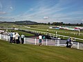 Chepstow Racecourse - geograph.org.uk - 2636144.jpg 640 × 480; 68 KB
-

-
 Church Lane St Arvans - geograph.org.uk - 5193482.jpg 597 × 800; 160 KB
-
 Cold Bath, Piercefield Walk, St Arvans.jpg 1,497 × 879; 440 KB
-
 Converted chapel in St Arvans - geograph.org.uk - 301188.jpg 640 × 427; 47 KB
-
 Cophill from the B4235 - geograph.org.uk - 1572997.jpg 640 × 480; 169 KB
-
 Corrugated barns at Porthcasseg farm - geograph.org.uk - 3101320.jpg 640 × 480; 82 KB
-
 Country near St Arvans - geograph.org.uk - 5150433.jpg 2,592 × 1,944; 1.4 MB
-
 Court Gardens, St Arvans - geograph.org.uk - 5192952.jpg 800 × 600; 158 KB
-

-
 Devauden Road, St Arvans - geograph.org.uk - 2710900.jpg 640 × 610; 93 KB
-
 Distances from St Arvans - geograph.org.uk - 5193420.jpg 800 × 771; 217 KB
-
 Disused lime kilns, Cockshoot Wood, near Chepstow - geograph.org.uk - 3445615.jpg 1,600 × 1,200; 934 KB
-
 Drinking fountain St Arvans - geograph.org.uk - 272620.jpg 480 × 640; 189 KB
-
 East side of St Arvans Parish Church - geograph.org.uk - 5193529.jpg 800 × 529; 135 KB
-
 End of the 30 zone through St Arvans - geograph.org.uk - 5193083.jpg 800 × 438; 119 KB
-
 Entrance to Chepstow Racecourse - geograph.org.uk - 2711056.jpg 640 × 414; 64 KB
-

-
 Explanation board, Wye Valley - geograph.org.uk - 2088406.jpg 640 × 480; 129 KB
-
 Farm road to Gaer Hill Farm - geograph.org.uk - 2127493.jpg 1,024 × 681; 254 KB
-
 Farmland at St Arvans - geograph.org.uk - 803445.jpg 426 × 640; 108 KB
-
 Farmland in the Wye Valley - geograph.org.uk - 5774216.jpg 1,024 × 768; 239 KB
-
 Farmland near Wyndcliffe Court - geograph.org.uk - 803449.jpg 640 × 426; 78 KB
-
 Fenced path, St Arvans - geograph.org.uk - 5194180.jpg 737 × 800; 159 KB
-

-
 Fields and woods near Rossfield - geograph.org.uk - 5150424.jpg 2,360 × 1,428; 1.11 MB
-
 Footpath on a meadow's edge - geograph.org.uk - 2966066.jpg 1,024 × 577; 292 KB
-
 Footpath to Porthcasseg - geograph.org.uk - 1515219.jpg 640 × 480; 93 KB
-
 Fordwich Close, St Arvans - geograph.org.uk - 2710895.jpg 640 × 440; 79 KB
-
 Fordwich Close, St Arvans - geograph.org.uk - 5193412.jpg 800 × 682; 123 KB
-
 Forge Gardens houses, St Arvans - geograph.org.uk - 5192994.jpg 800 × 665; 185 KB
-
 Forge Gardens, St Arvans - geograph.org.uk - 5192947.jpg 800 × 588; 125 KB
-

-
 Former quarry face below Wynd Cliff - geograph.org.uk - 5773965.jpg 1,024 × 768; 320 KB
-
 Fountain Cottages, St Arvans - geograph.org.uk - 2710899.jpg 640 × 423; 63 KB
-

-

-
 Fryth Wood beside the B4293 - geograph.org.uk - 1805070.jpg 1,600 × 1,200; 750 KB
-
 General view, Chepstow Racecourse - geograph.org.uk - 2349507.jpg 2,560 × 1,384; 667 KB
-

-
 Grange Road houses, St Arvans - geograph.org.uk - 5192973.jpg 800 × 599; 117 KB
-
 Grange Road sign and notice, St Arvans - geograph.org.uk - 5194131.jpg 800 × 677; 141 KB
-
 Grange Road, St Arvans - geograph.org.uk - 5194174.jpg 800 × 600; 170 KB
-
 Green meadows west of St.Arvan's - geograph.org.uk - 3004742.jpg 1,024 × 577; 292 KB
-
 Green pastures - geograph.org.uk - 3004736.jpg 1,024 × 577; 291 KB
-
 Green turning to gold - geograph.org.uk - 5842278.jpg 1,600 × 900; 792 KB
-
 Grotto on the Piercefield Walks - geograph.org.uk - 206130.jpg 640 × 480; 538 KB
-
 Hog roast unit, Chepstow Racecourse - geograph.org.uk - 2711342.jpg 640 × 488; 77 KB
-
 House on Devauden Road - geograph.org.uk - 5605329.jpg 1,024 × 796; 190 KB
-
 Information board, Upper Wyndcliff - geograph.org.uk - 803451.jpg 426 × 640; 78 KB
-
 Junction north of St Arvans - geograph.org.uk - 5193122.jpg 800 × 684; 176 KB
-

-
 King George's Field, St Arvans - geograph.org.uk - 5194153.jpg 800 × 600; 157 KB
-
 Laurel Park, St Arvans - geograph.org.uk - 5194178.jpg 800 × 469; 115 KB
-
 Long lay-by opposite Chepstow Racecourse - geograph.org.uk - 1702408.jpg 1,600 × 800; 300 KB
-
 Looking across the B4235 from Great Barnets Wood entrance - geograph.org.uk - 4238565.jpg 2,560 × 1,920; 2.15 MB
-
 Main road through St Arvans - geograph.org.uk - 5189840.jpg 800 × 713; 133 KB
-
 Main stands at Chepstow Racecourse - geograph.org.uk - 2711074.jpg 640 × 340; 44 KB
-
 Manor View, St Arvans - geograph.org.uk - 2088446.jpg 640 × 460; 85 KB
-
 Masts on Gaer Hill - geograph.org.uk - 2127477.jpg 681 × 1,024; 157 KB
-
 Meander in the River Wye Valley - geograph.org.uk - 5773930.jpg 1,024 × 767; 164 KB
-
 Milestone - to Chepstow 3 Miles - geograph.org.uk - 202429.jpg 427 × 640; 384 KB
-

-
 Minor Road at Upper Martridge Wood - geograph.org.uk - 4508469.jpg 640 × 428; 119 KB
-

-
 NE boundary of St Arvans - geograph.org.uk - 2710510.jpg 640 × 397; 94 KB
-
 North side of St Arvans Parish Church - geograph.org.uk - 5194076.jpg 800 × 638; 125 KB
-
 Northern boundary of Chepstow - geograph.org.uk - 3263348.jpg 640 × 543; 108 KB
-

-

-
 One of the lodges at Oakgrove - geograph.org.uk - 5585946.jpg 1,600 × 1,199; 825 KB
-

-
 Parkfield B^B, St Arvans - geograph.org.uk - 2710617.jpg 640 × 544; 98 KB
-
 Parkfield B^B, St Arvans - geograph.org.uk - 5189826.jpg 800 × 591; 131 KB
-

-

-

-

-
 Patched surface on the A466, St Arvans - geograph.org.uk - 5193091.jpg 638 × 800; 166 KB
-
 Path in Cockshoot Wood - geograph.org.uk - 5149819.jpg 2,514 × 1,886; 1.6 MB
-
 Path in Wyndcliff Wood - geograph.org.uk - 3101213.jpg 640 × 480; 147 KB
-
 Path junction in Wyndcliff Wood - geograph.org.uk - 5773162.jpg 1,024 × 768; 393 KB
-
 Path to Livox Farm - geograph.org.uk - 3939381.jpg 4,320 × 3,240; 2.9 MB
-
 Pathway through rock cutting - geograph.org.uk - 5773969.jpg 1,024 × 768; 356 KB
-
 Penterry church yew - geograph.org.uk - 1535988.jpg 640 × 480; 116 KB
-
 Penterry church yew - geograph.org.uk - 1536011.jpg 640 × 480; 72 KB
-
 Penterry churchyard cross - geograph.org.uk - 1535969.jpg 640 × 480; 131 KB
-
 Picnic bench overlooking the Wye valley - geograph.org.uk - 917955.jpg 640 × 452; 105 KB
-
 Picnic spot in Wyndcliff Wood - geograph.org.uk - 2088420.jpg 640 × 480; 147 KB
-
 Picnic table with a view - geograph.org.uk - 3385879.jpg 640 × 480; 74 KB
-
 Pierce Wood Camp (West), Piercefield, St Arvans.jpg 3,968 × 2,976; 2.59 MB
-
 Piercefield Avenue, Chepstow - geograph.org.uk - 5150488.jpg 2,592 × 1,944; 1.31 MB
-
 Piercefield House - geograph.org.uk - 3763100.jpg 1,600 × 1,071; 431 KB
-
 Piercefield Park alcove - geograph.org.uk - 3905284.jpg 640 × 480; 129 KB
-
 Piercefield Park Druid's Temple - geograph.org.uk - 3905307.jpg 640 × 480; 121 KB
-
 Piercefield Park Giant's Cave - geograph.org.uk - 3905722.jpg 640 × 480; 112 KB
-
 Piercefield Park Grotto - geograph.org.uk - 3905300.jpg 640 × 480; 131 KB
-
 Piercefield Park platform - geograph.org.uk - 3905290.jpg 640 × 480; 138 KB
-
 Piercefield Terrace, St Arvans - geograph.org.uk - 5193457.jpg 797 × 800; 148 KB
-
 Pond on Gaer Hill - geograph.org.uk - 1555314.jpg 640 × 480; 111 KB
-
 Pool near Porthcasseg - geograph.org.uk - 3101315.jpg 640 × 480; 137 KB
-
 Pool on Gaer Hill - geograph.org.uk - 2128248.jpg 1,024 × 681; 291 KB
-

-

-

-
 Reaching the Winning Post, Chepstow Racecourse - geograph.org.uk - 2349493.jpg 2,560 × 1,920; 2.63 MB
-
 Remains of a stone wall - geograph.org.uk - 2128282.jpg 1,024 × 681; 302 KB
-
 Remains of a wall - geograph.org.uk - 2128302.jpg 1,024 × 681; 270 KB
-
 Remains of old lime kilns - geograph.org.uk - 3101354.jpg 640 × 480; 104 KB
-
 Ride ^ Stride St Arvans - geograph.org.uk - 5189830.jpg 800 × 606; 104 KB
-
 Ride ^ Stride, St Arvans - geograph.org.uk - 2710738.jpg 640 × 489; 74 KB
-
 Road from Chepstow to St Arvans - geograph.org.uk - 3263206.jpg 640 × 477; 98 KB
-
 Road from St Arvans towards Tintern - geograph.org.uk - 5189827.jpg 800 × 611; 153 KB
-

-
 Road to Upper Martridge Wood - geograph.org.uk - 5588921.jpg 1,600 × 1,202; 697 KB
-
 Robins Nursery, St Arvans - geograph.org.uk - 5189687.jpg 800 × 585; 159 KB
-
 Rock tunnel below Piercefield Cliffs - geograph.org.uk - 5774210.jpg 1,024 × 768; 353 KB
-
 Seats by an isolated viewpoint - geograph.org.uk - 5842312.jpg 1,600 × 1,200; 939 KB
-
 Sheep on Gaer Hill Farm - geograph.org.uk - 1555343.jpg 640 × 480; 116 KB
-
 Sign,Lower Wyndcliff, Wye Valley - geograph.org.uk - 1776217.jpg 640 × 480; 82 KB
-
 South side of St Arvans Parish Church - geograph.org.uk - 5193535.jpg 800 × 610; 182 KB
-
 South side of the Piercefield, St Arvans - geograph.org.uk - 5189838.jpg 800 × 672; 122 KB
-

-

-

-
 Spring in Lower Martridge Wood - geograph.org.uk - 5774203.jpg 1,024 × 768; 389 KB
-
 Springtime in Cockshoot Wood, near Chepstow - geograph.org.uk - 3445610.jpg 2,560 × 1,920; 3.04 MB
-
 Squirrel Cottages, St Arvans - geograph.org.uk - 5193468.jpg 800 × 633; 116 KB
-
 Squirrel Cottages, St Arvans - geograph.org.uk - 5605334.jpg 1,024 × 768; 165 KB
-
 St Arvans - geograph.org.uk - 3771940.jpg 1,600 × 1,071; 330 KB
-
 St Arvans Cemetery - geograph.org.uk - 5194099.jpg 800 × 542; 108 KB
-
 St Arvans houses - geograph.org.uk - 2711008.jpg 640 × 487; 78 KB
-
 St Arvans Meeting Rooms, St Arvans - geograph.org.uk - 5194115.jpg 800 × 716; 188 KB
-
 St Arvans Memorial Hall - geograph.org.uk - 5189823.jpg 800 × 753; 227 KB
-
 St Arvans Parish Church tower - geograph.org.uk - 5194107.jpg 800 × 600; 115 KB
-
 St Arvans Victorian drinking fountain - geograph.org.uk - 2710888.jpg 640 × 589; 128 KB
-
 St Arvans village hall - geograph.org.uk - 2710581.jpg 640 × 525; 105 KB
-

-
 Stairway on Wynd Cliff - geograph.org.uk - 5773957.jpg 1,024 × 768; 298 KB
-

-
 Start of the 30 zone in St Arvans - geograph.org.uk - 5189673.jpg 800 × 721; 216 KB
-
 Steps to the top of Wynd Cliff - geograph.org.uk - 5773953.jpg 768 × 1,024; 396 KB
-
 Sweet chestnut tree - geograph.org.uk - 803447.jpg 426 × 640; 115 KB
-
 The A466, below Wynd Cliff - geograph.org.uk - 5773978.jpg 1,024 × 768; 307 KB
-
 The Alcove, Piercefield, St Arvans.jpg 3,968 × 2,976; 2.3 MB
-
 The B4295 at Cophill - geograph.org.uk - 4263145.jpg 2,560 × 1,920; 2.22 MB
-
 The drive to "Rossfield", Howick, near Chepstow - geograph.org.uk - 3445587.jpg 2,560 × 1,920; 2.98 MB
-
 The Eagle's Nest - geograph.org.uk - 2344671.jpg 640 × 480; 146 KB
-

-
 The Giant's Cave - geograph.org.uk - 202591.jpg 640 × 480; 462 KB
-
 The Grotto in Piercefield Woods - geograph.org.uk - 2344845.jpg 640 × 480; 149 KB
-
 The lane to St Arvans - geograph.org.uk - 5150437.jpg 2,592 × 1,944; 1.6 MB
-

-
 The Nook, Devauden Road, St Arvans - geograph.org.uk - 5193003.jpg 800 × 590; 109 KB
-

-

-

-
 The Piercefield Inn, St Arvans - geograph.org.uk - 5605341.jpg 1,024 × 749; 125 KB
-
 The Piercefield pub, St Arvans - geograph.org.uk - 3939369.jpg 4,320 × 3,240; 2.82 MB
-
 The Piercefield St Arvans - geograph.org.uk - 5189829.jpg 800 × 436; 74 KB
-
 The Piercefield, St Arvans - geograph.org.uk - 1705713.jpg 800 × 601; 119 KB
-

-

-
 The Row, St Arvans - geograph.org.uk - 5193460.jpg 800 × 626; 127 KB
-

-

-

-

-
 The Wye, from Wyndcliff Wood - geograph.org.uk - 4925351.jpg 3,489 × 2,320; 3.1 MB
-
 The Wynd Cliff - geograph.org.uk - 301194.jpg 427 × 640; 113 KB


,_Piercefield,_St_Arvans.jpg)


