Category:St Mary's church, Capel-le-Ferne
Jump to navigation
Jump to search
| Object location | | View all coordinates using: OpenStreetMap |
|---|
church in Capel-le-Ferne, Kent, England, UK  | |||||
| Upload media | |||||
| Instance of | |||||
|---|---|---|---|---|---|
| Location | Capel-le-Ferne, Dover, Kent, South East England, England | ||||
| Architectural style | |||||
| Heritage designation |
| ||||
| Inception |
| ||||
| official website | |||||
 | |||||
Media in category "St Mary's church, Capel-le-Ferne"
The following 13 files are in this category, out of 13 total.
-
 Bergens Museums aarbog (1908) (19744506443).jpg 1,512 × 1,812; 1,005 KB
-

-
 Lych gate at St Mary's church - geograph.org.uk - 938214.jpg 640 × 480; 185 KB
-
 Memorial plaque at Capel Le Fern, Kent.jpg 3,264 × 1,836; 2.19 MB
-
 Notice on the church of St Mary - geograph.org.uk - 930180.jpg 480 × 640; 181 KB
-
 St Mary's church - geograph.org.uk - 1568889.jpg 640 × 217; 46 KB
-
 St Mary's church Capel-le-Ferne - geograph.org.uk - 938217.jpg 640 × 480; 238 KB
-
 St Mary's church from the NW - geograph.org.uk - 938219.jpg 640 × 480; 241 KB
-
 St Mary, Capel le Ferne, Kent - geograph.org.uk - 325552.jpg 640 × 393; 133 KB
-
 St Mary, Capel le Ferne, Kent - geograph.org.uk - 325554.jpg 640 × 389; 114 KB
-
 St Mary, Capel le Ferne, Kent - Window - geograph.org.uk - 325557.jpg 376 × 640; 129 KB
-
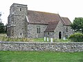 The church of St Mary, Capel-Le-Ferne - geograph.org.uk - 930179.jpg 640 × 480; 205 KB
-
 View from a country churchyard - geograph.org.uk - 1562144.jpg 640 × 479; 320 KB
_(19744506443).jpg)


