Category:St Sylvester's Church, Vauxhall
Jump to navigation
Jump to search
| Object location | | View all coordinates using: OpenStreetMap |
|---|
church building in United Kingdom  | |||||
| Upload media | |||||
| Instance of | |||||
|---|---|---|---|---|---|
| Location |
| ||||
 | |||||
Subcategories
This category has only the following subcategory.
T
Media in category "St Sylvester's Church, Vauxhall"
The following 5 files are in this category, out of 5 total.
-
-
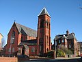
 St Sylvester's, Vauxhall 2019-1.jpg 3,936 × 3,072; 7.53 MB
-
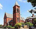 St Sylvester's, Vauxhall 2019-2.jpg 3,882 × 3,216; 8.59 MB
-
 St Sylvester's, Vauxhall 2019-3.jpg 4,086 × 3,396; 9.01 MB
-
 St Sylvester's, Vauxhall 2019-4.jpg 3,951 × 3,315; 9.1 MB


Categories:
- 1880s brick churches in England
- 1880s church towers in England
- 1880s Gothic Revival churches in England
- 19th-century churches in Merseyside
- Brick buttresses in England
- Buttresses in Merseyside
- Churches in England built in 1889
- Gothic Revival brick churches in Merseyside
- Roman Catholic churches in Liverpool
- Sylvester I churches in England
- Former churches in Liverpool
- Churches in Vauxhall, Liverpool
- Pugin and Pugin