Category:Stadhuis Culemborg
Jump to navigation
Jump to search
| Object location | | View all coordinates using: OpenStreetMap |
|---|
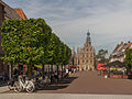
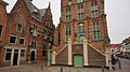
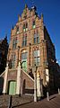
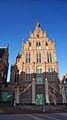
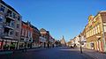
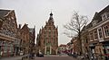
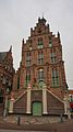
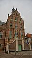
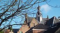
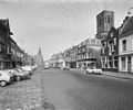
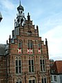
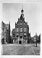
Nederlands: Afbeeldingen van het stadhuis van Culemborg, Oude Vismarkt 4, 4101 CA Culemborg. Gelegen nabij de Markt van Culemborg in het centrum van Culemborg in de provincie Gelderland in Nederland
English: Pictures of the town hall of Culemborg, Oude Vismarkt 4, 4101 CA Culemborg. Near the Markt in the center of Culemborg in the Dutch province of Gelderland in the Netherlands
|
This is a category about rijksmonument number 11556
|
 | |||||
| Upload media | |||||
| Instance of | |||||
|---|---|---|---|---|---|
| Location | Culemborg, Gelderland, Netherlands | ||||
| Located on street |
| ||||
| Architectural style | |||||
| Heritage designation |
| ||||
| Inception |
| ||||
 | |||||
Subcategories
This category has the following 4 subcategories, out of 4 total.
D
- Detail Stadhuis Culemborg (17 F)
I
Media in category "Stadhuis Culemborg"
The following 53 files are in this category, out of 53 total.
-
 11556 Stadhuis (2).jpg 2,910 × 1,920; 4.89 MB
-
 11556 Stadhuis.jpg 2,522 × 3,000; 6.35 MB
-
 Culemborg, de Markt met het stadhuis RM11556 foto13 2015-08-06 13.29.jpg 4,349 × 3,262; 9.54 MB
-
 Culemborg, Netherlands - panoramio (104).jpg 2,048 × 1,148; 570 KB
-
 Culemborg, Netherlands - panoramio (106).jpg 1,148 × 2,048; 516 KB
-
 Culemborg, Netherlands - panoramio (134).jpg 2,048 × 1,148; 514 KB
-
 Culemborg, Netherlands - panoramio (136).jpg 1,148 × 2,048; 556 KB
-
 Culemborg, Netherlands - panoramio (139).jpg 1,148 × 2,048; 522 KB
-
 Culemborg, Netherlands - panoramio (159).jpg 4,896 × 3,264; 2.27 MB
-
 Culemborg, Netherlands - panoramio (161).jpg 2,176 × 3,264; 1.44 MB
-
 Culemborg, Netherlands - panoramio (19).jpg 2,048 × 1,148; 477 KB
-
 Culemborg, Netherlands - panoramio (20).jpg 1,148 × 2,048; 505 KB
-
 Culemborg, Netherlands - panoramio (34).jpg 1,148 × 2,048; 414 KB
-
 Culemborg, Netherlands - panoramio (4).jpg 2,048 × 1,148; 365 KB
-
 Culemborg, Netherlands - panoramio (69).jpg 2,048 × 1,148; 452 KB
-
 Culemborg, Netherlands - panoramio (7).jpg 2,048 × 1,148; 546 KB
-
 Culemborg, Netherlands - panoramio (87).jpg 2,048 × 1,148; 468 KB
-
 Culemborg, Netherlands - panoramio (90).jpg 1,148 × 2,048; 416 KB
-
 Culemborg, Netherlands - panoramio (93).jpg 1,148 × 2,048; 561 KB
-
 Culemborg, Netherlands - panoramio (97).jpg 1,148 × 2,048; 458 KB
-
 Culemborg, view at the westerly façade of the town hall at Wagenweg, by Jan Weissenbruch.jpg 1,060 × 1,454; 1.11 MB
-
 Culemborg11556 Stadhuis.jpg 2,521 × 2,443; 5.41 MB
-
 Exterieur - Culemborg - 20051529 - RCE.jpg 958 × 1,200; 169 KB
-
 Het Stadhuis - panoramio.jpg 3,296 × 1,854; 922 KB
-
 Het Stadhuis vanf de Lange Meent - panoramio.jpg 3,296 × 1,854; 849 KB
-
 Kaak stadhuis Culemborg.jpg 2,592 × 4,608; 7.34 MB
-
 Koningin, bezoeken, Juliana, koningin, Bestanddeelnr 905-1361.jpg 2,868 × 2,620; 1.36 MB
-
 Martktplein culemborg.JPG 3,264 × 2,448; 1.96 MB
-
 Oude stadhuis van Culemborg 01.jpg 2,084 × 4,624; 4.82 MB
-
 Oude stadhuis van Culemborg 02.jpg 2,084 × 4,624; 3.44 MB
-
 Oude stadhuis van Culemborg 03.jpg 2,084 × 4,624; 4.69 MB
-
 Overzicht - Culemborg - 20051950 - RCE.jpg 965 × 1,200; 192 KB
-
 Overzicht gevelwand - Culemborg - 20051970 - RCE.jpg 1,200 × 810; 186 KB
-
 Overzicht Markt - Culemborg - 20051934 - RCE.jpg 1,200 × 959; 191 KB
-
 Overzicht Markt - Culemborg - 20051935 - RCE.jpg 1,200 × 1,002; 224 KB
-
 Overzicht voorgevel - Culemborg - 20051526 - RCE.jpg 894 × 1,200; 161 KB
-

-
 P1070527 Culemborg.JPG 3,264 × 2,448; 3.73 MB
-
 Stadhuis Culemborg.JPG 2,448 × 3,264; 1.8 MB
-
 T.T Raadhuis Culemborg.JPG 960 × 1,280; 334 KB
-
 Uitzicht op het stadhuis vanaf de Vierkante Toren - panoramio.jpg 1,792 × 1,184; 249 KB
-
 Van af Toren, kerk - Culemborg - 20051502 - RCE.jpg 1,200 × 937; 303 KB
-

-
 Voorgevel - Culemborg - 20051530 - RCE.jpg 894 × 1,200; 205 KB
-
 Voorgevel - Culemborg - 20051531 - RCE.jpg 882 × 1,200; 187 KB
-
 Voorgevel en zijgevel rechts - Culemborg - 20051504 - RCE.jpg 912 × 1,200; 235 KB
-
 Voorgevel in omgeving - Culemborg - 20325711 - RCE.jpg 950 × 1,200; 162 KB
-
 Voorzijde - Culemborg - 20051508 - RCE.jpg 977 × 1,200; 256 KB
-
 Zicht op de Binnenpoort vanaf de Varkenmarkt - Culemborg - 20051485 - RCE.jpg 896 × 1,200; 236 KB
-

-
 Zijgevel - Culemborg - 20051509 - RCE.jpg 967 × 1,200; 270 KB
-
 Zijgevel en kaak - Culemborg - 20051506 - RCE.jpg 831 × 1,200; 269 KB
-
 Zijgevel en kaak - Culemborg - 20051507 - RCE.jpg 822 × 1,200; 192 KB
.jpg)


.jpg)
.jpg)
.jpg)
.jpg)
.jpg)
.jpg)
.jpg)
.jpg)
.jpg)
.jpg)
.jpg)
.jpg)
.jpg)
.jpg)
.jpg)
.jpg)
.jpg)


