Category:Stania State
Jump to navigation
Jump to search
| Object location | | View all coordinates using: OpenStreetMap |
|---|
 | |||||
| Upload media | |||||
| Instance of | |||||
|---|---|---|---|---|---|
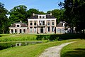
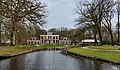
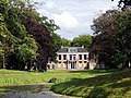
| Location | Oentsjerk, Friesland, Netherlands | ||||
| Has part(s) | |||||
| Heritage designation |
| ||||
 | |||||
|
This is a category about rijksmonumentcomplex number 519579
|
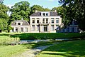
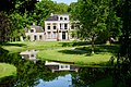
hoofdgebouw:
|
This is a category about rijksmonument number 519581
|
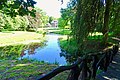
historische tuin- en parkaanleg:
|
This is a category about rijksmonument number 519582
|
berging:
|
This is a category about rijksmonument number 519583
|
secundair toegangshek:
|
This is a category about rijksmonument number 519584
|
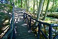
drie-armige houten brug:
|
This is a category about rijksmonument number 519585
|
zandstenen vaas:
|
This is a category about rijksmonument number 519586
|
eendengrot:
|
This is a category about rijksmonument number 519587
|
oranjeriekas:
|
This is a category about rijksmonument number 519588
|
kweekbak:
|
This is a category about rijksmonument number 519589
|
lange kweekbak:
|
This is a category about rijksmonument number 519590
|
hekpijlers en hek:
|
This is a category about rijksmonument number 519608
|
voormalige bakstenen boerderij:
|
This is a category about rijksmonument number 519609
|
toegangshek aan de Rengersweg:
|
This is a category about rijksmonument number 529434
|
| Address |
|
Subcategories
This category has the following 2 subcategories, out of 2 total.
K
- Kassen, Stania (9 F)
S
Media in category "Stania State"
The following 46 files are in this category, out of 46 total.
-
 20200902 Stania State1 Oentsjerk.jpg 5,184 × 3,456; 5.15 MB
-
 20200902 Staniastate2 Oentsjerk.jpg 5,184 × 3,456; 4.7 MB
-
 20200902 Staniastate3 Oentsjerk.jpg 4,032 × 3,024; 3.27 MB
-
 20200902 Staniastate4 Oentsjerk.jpg 5,184 × 3,456; 4.65 MB
-
 20200902 Staniastate5 Oentsjerk.jpg 5,184 × 3,456; 4.61 MB
-
 20200902 Staniastate6 Oentsjerk.jpg 5,184 × 3,456; 6.02 MB
-
 20200902 Staniastate7 Oentsjerk.jpg 5,184 × 3,456; 4.2 MB
-
 20210615 Staniastate1.jpg 5,184 × 3,456; 4.31 MB
-
 20210615 Staniastate2.jpg 5,184 × 3,456; 5.03 MB
-
 20210615 Staniastate3.jpg 5,184 × 3,456; 4.39 MB
-
 Achtergevel - Oenkerk - 20171279 - RCE.jpg 1,200 × 963; 334 KB
-
 Drie-armige houten brug, Stania State, Oenkerk.JPG 4,608 × 3,456; 3.48 MB
-
 Eendengrot, Stania State, Oenkerk.JPG 4,608 × 3,456; 3.16 MB
-
 Fair, Stania state, Oenkerk.JPG 4,608 × 3,456; 3.04 MB
-
-
 Interieur, begane grond, overzicht gang - Oenkerk - 20414249 - RCE.jpg 1,200 × 1,199; 147 KB
-

-

-
 Interieur, eerste verdieping, overzicht linker kamer - Oenkerk - 20414254 - RCE.jpg 1,200 × 1,200; 250 KB
-
 Interieur, eerste verdieping, overzicht linker kamer - Oenkerk - 20414255 - RCE.jpg 1,200 × 1,200; 215 KB
-

-

-
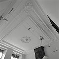
 Interieur, eerste verdieping, overzicht trappenhuis - Oenkerk - 20414248 - RCE.jpg 1,200 × 1,200; 159 KB
-

-
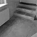 Interieur, natuurstenen vloer met trap in de kelder - Oenkerk - 20414256 - RCE.jpg 1,200 × 1,200; 188 KB
-

-
 Interieur, overzicht kantoorruimte - Oenkerk - 20414240 - RCE.jpg 1,200 × 1,200; 156 KB
-

-
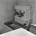 Interieur, pomp en gootsteen in de kelder - Oenkerk - 20414238 - RCE.jpg 1,200 × 1,200; 180 KB
-
 Interieur, trappenhuis - Oenkerk - 20414244 - RCE.jpg 1,200 × 1,200; 167 KB
-
 Interieur, wit marmeren fonteintje - Oenkerk - 20414239 - RCE.jpg 1,200 × 1,200; 139 KB
-
 Interieur, zolder (archief) - Oenkerk - 20414247 - RCE.jpg 1,200 × 1,200; 210 KB
-

-
 Linker zijgevel - Oenkerk - 20171277 - RCE.jpg 1,200 × 960; 286 KB
-
 Oentsjerk, Staniastate.jpg 3,876 × 2,272; 4.19 MB
-
 Overzicht achtergevel - Oenkerk - 20171278 - RCE.jpg 1,200 × 955; 360 KB
-
 Overzicht fruitmuur met leibomen - Oenkerk - 20405905 - RCE.jpg 1,200 × 1,198; 483 KB
-
 Overzicht vanuit het park - Oenkerk - 20171275 - RCE.jpg 1,200 × 958; 272 KB
-
 Rengersweg 100, Oenkerk.JPG 4,608 × 3,456; 2.97 MB
-
 Stania State hoofdgebouw.jpg 4,608 × 3,456; 3.16 MB
-
 Stania State toegangshek.JPG 2,996 × 1,982; 5.03 MB
-
 Tekening, tuinontwerp - Oenkerk - 20410363 - RCE.jpg 880 × 1,200; 200 KB
-
 Toegangshek aan de Rengersweg, Stania State, Oenkerk.JPG 4,608 × 3,456; 3.01 MB
-
 Vooraanzicht - Oenkerk - 20171266 - RCE.jpg 1,200 × 808; 312 KB
-
 Voorgevel - Oenkerk - 20171272 - RCE.jpg 1,200 × 810; 393 KB
-
 Voorzijde - Oenkerk - 20171276 - RCE.jpg 1,200 × 955; 246 KB


_met_schouw_-_Oenkerk_-_20414253_-_RCE.jpg)
_-_Oenkerk_-_20414245_-_RCE.jpg)


_met_trappenhuis_en_kapconstructie_-_Oenkerk_-_20414243_-_RCE.jpg)


_-_Oenkerk_-_20414247_-_RCE.jpg)


