Category:Stark Covered Bridge
Jump to navigation
Jump to search
 | |||||
| Upload media | |||||
| Instance of | |||||
|---|---|---|---|---|---|
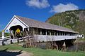
| Location | Coös County, New Hampshire | ||||
| Crosses | |||||
| Heritage designation |
| ||||
| Length |
| ||||
 | |||||
|
This is a category about a place or building that is listed on the National Register of Historic Places in the United States of America. Its reference number is 80000283. |
Media in category "Stark Covered Bridge"
The following 4 files are in this category, out of 4 total.
-
 Stark Covered Bridge 5.JPG 3,603 × 2,379; 2.64 MB
-
 Stark Covered Bridge 6.JPG 3,648 × 2,447; 2.44 MB
-
 Stark Covered Bridge, New Hampshire (30288446792).jpg 5,091 × 3,394; 11.7 MB
-
 UpperAmmonoosuc.jpg 1,296 × 976; 747 KB


.jpg)