Category:Stellungssystem (Sondermunitionslager Dülmen-Visbeck)
Jump to navigation
Jump to search
| | View all coordinates using: OpenStreetMap |
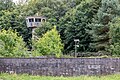
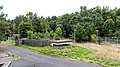
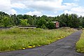
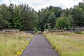
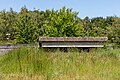
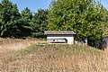
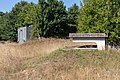
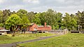
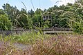
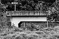
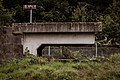
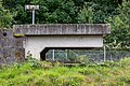
Deutsch: Stellungssystem mit Laufgängen und Kampfständen/Gefechtsstellungen im Sondermunitionslager Dülmen-Visbeck.
Media in category "Stellungssystem (Sondermunitionslager Dülmen-Visbeck)"
The following 48 files are in this category, out of 48 total.
-
 Dülmen, Kirchspiel, ehem. Sondermunitionslager Visbeck -- 2020 -- 2462.jpg 6,720 × 4,480; 19.08 MB
-
 Dülmen, Kirchspiel, ehem. Sondermunitionslager Visbeck -- 2022 -- 4464.jpg 6,720 × 4,480; 22.51 MB
-
 Dülmen, Kirchspiel, ehem. Sondermunitionslager Visbeck -- 2022 -- 4466.jpg 6,720 × 4,480; 22.54 MB
-
 Dülmen, Kirchspiel, ehem. Sondermunitionslager Visbeck -- 2022 -- 4467.jpg 6,720 × 3,780; 18.38 MB
-
 Dülmen, Kirchspiel, ehem. Sondermunitionslager Visbeck -- 2022 -- 4468.jpg 6,720 × 3,780; 19.19 MB
-
 Dülmen, Kirchspiel, ehem. Sondermunitionslager Visbeck -- 2022 -- 4473-6.jpg 12,883 × 3,439; 30.71 MB
-
 Dülmen, Kirchspiel, ehem. Sondermunitionslager Visbeck -- 2022 -- 4477.jpg 6,720 × 4,200; 19.63 MB
-
 Dülmen, Kirchspiel, ehem. Sondermunitionslager Visbeck, Bereich der US Army -- 2019 -- 6526.jpg 6,720 × 4,480; 17.31 MB
-
 Dülmen, Kirchspiel, ehem. Sondermunitionslager Visbeck, Bereich der US Army -- 2019 -- 6528.jpg 6,720 × 4,480; 16.98 MB
-
 Dülmen, Kirchspiel, ehem. Sondermunitionslager Visbeck, Bereich der US Army -- 2020 -- 7473.jpg 6,632 × 4,421; 26.34 MB
-
 Dülmen, Kirchspiel, ehem. Sondermunitionslager Visbeck, Bereich der US Army -- 2020 -- 7474.jpg 6,647 × 4,431; 24.98 MB
-
 Dülmen, Kirchspiel, ehem. Sondermunitionslager Visbeck, Bereich der US Army -- 2020 -- 7493.jpg 4,480 × 6,720; 20.11 MB
-
 Dülmen, Kirchspiel, ehem. Sondermunitionslager Visbeck, Bereich der US Army -- 2020 -- 7520.jpg 6,720 × 4,480; 19.13 MB
-
 Dülmen, Kirchspiel, ehem. Sondermunitionslager Visbeck, Bereich der US Army -- 2020 -- 8389.jpg 6,720 × 3,780; 23.38 MB
-
 Dülmen, Kirchspiel, ehem. Sondermunitionslager Visbeck, Bereich der US Army -- 2020 -- 8391.jpg 6,720 × 4,480; 26.72 MB
-
 Dülmen, Kirchspiel, ehem. Sondermunitionslager Visbeck, Bereich der US Army -- 2020 -- 8399.jpg 6,720 × 4,480; 31.95 MB
-
 Dülmen, Kirchspiel, ehem. Sondermunitionslager Visbeck, Bereich der US Army -- 2020 -- 8885.jpg 6,720 × 4,480; 17.43 MB
-
 Dülmen, Kirchspiel, ehem. Sondermunitionslager Visbeck, Bereich der US Army -- 2022 -- 4326.jpg 6,720 × 4,480; 26.58 MB
-
 Dülmen, Kirchspiel, ehem. Sondermunitionslager Visbeck, Bereich der US Army -- 2022 -- 4328.jpg 6,720 × 4,480; 24.52 MB
-

-

-
 Dülmen, Kirchspiel, ehem. Sondermunitionslager Visbeck, Eingangsbereich -- 2024 -- 4309.jpg 6,642 × 3,736; 19.02 MB
-
 Dülmen, Kirchspiel, ehem. Sondermunitionslager Visbeck, Eingangsbereich -- 2024 -- 4311.jpg 6,683 × 3,759; 17.22 MB
-
 Dülmen, Kirchspiel, ehem. Sondermunitionslager Visbeck, Laufgang -- 2022 -- 4391 (bw).jpg 6,720 × 4,480; 18.64 MB
-
-
 Dülmen, Kirchspiel, ehem. Sondermunitionslager Visbeck, Laufgang -- 2022 -- 4391.jpg 6,720 × 4,480; 26.95 MB
-
 Dülmen, Kirchspiel, ehem. Sondermunitionslager Visbeck, Laufgang -- 2022 -- 4394.jpg 6,720 × 4,480; 25.09 MB
-
 Dülmen, Kirchspiel, ehem. Sondermunitionslager Visbeck, Laufgang -- 2022 -- 4461 (bw).jpg 4,480 × 5,600; 13.77 MB
-
 Dülmen, Kirchspiel, ehem. Sondermunitionslager Visbeck, Laufgang -- 2022 -- 4461.jpg 4,480 × 6,720; 18.04 MB
-
 Dülmen, Kirchspiel, ehem. Sondermunitionslager Visbeck, Laufgang -- 2022 -- 4462.jpg 4,480 × 6,720; 20.56 MB
-
 Dülmen, Kirchspiel, ehem. Sondermunitionslager Visbeck, Laufgang -- 2023 -- 6796 (bw).jpg 6,590 × 4,393; 20.04 MB
-
 Dülmen, Kirchspiel, ehem. Sondermunitionslager Visbeck, Laufgang -- 2023 -- 6796.jpg 6,590 × 4,393; 26.05 MB
-
 Dülmen, Kirchspiel, ehem. Sondermunitionslager Visbeck, Laufgang -- 2023 -- 6815.jpg 6,712 × 4,475; 30.85 MB
-
 Dülmen, Kirchspiel, ehem. Sondermunitionslager Visbeck, Laufgang -- 2023 -- 6820.jpg 6,712 × 4,475; 26.29 MB
-
 Dülmen, Kirchspiel, ehem. Sondermunitionslager Visbeck, Laufgänge -- 2023 -- 8942.jpg 6,720 × 4,480; 27.24 MB
-
 Dülmen, Kirchspiel, ehem. Sondermunitionslager Visbeck, Unterstand -- 2019 -- 6443.jpg 6,681 × 4,454; 22.02 MB
-
 Dülmen, Kirchspiel, ehem. Sondermunitionslager Visbeck, Unterstand -- 2019 -- 6444.jpg 6,720 × 4,480; 23.15 MB
-
 Dülmen, Kirchspiel, ehem. Sondermunitionslager Visbeck, Unterstand -- 2019 -- 6501.jpg 6,720 × 4,480; 15.76 MB
-
 Dülmen, Kirchspiel, ehem. Sondermunitionslager Visbeck, Unterstand -- 2019 -- 6504.jpg 6,720 × 4,480; 15.63 MB
-
 Dülmen, Kirchspiel, ehem. Sondermunitionslager Visbeck, Unterstand -- 2019 -- 6505.jpg 6,706 × 4,471; 16.56 MB
-
 Dülmen, Kirchspiel, ehem. Sondermunitionslager Visbeck, Unterstand -- 2020 -- 2441.jpg 6,720 × 4,480; 15.3 MB
-
 Dülmen, Kirchspiel, ehem. Sondermunitionslager Visbeck, Unterstand -- 2022 -- 4465 (bw).jpg 6,720 × 4,480; 17.04 MB
-
-
 Dülmen, Kirchspiel, ehem. Sondermunitionslager Visbeck, Unterstand -- 2022 -- 4465 (kreativ).jpg 6,720 × 4,480; 23.12 MB
-
 Dülmen, Kirchspiel, ehem. Sondermunitionslager Visbeck, Unterstand -- 2022 -- 4465.jpg 6,720 × 4,480; 22.16 MB
-
 Dülmen, Kirchspiel, ehem. Sondermunitionslager Visbeck, Unterstand -- 2023 -- 8962.jpg 6,720 × 4,480; 20.49 MB
-
 Dülmen, Kirchspiel, ehem. Sondermunitionslager Visbeck, Unterstände -- 2022 -- 4485.jpg 6,720 × 4,480; 18.77 MB
-


.jpg)
.jpg)


.jpg)


.jpg)


.jpg)
.jpg)
.jpg)


