Category:Sugarloaf Point Light
Jump to navigation
Jump to search
| Object location | | View all coordinates using: OpenStreetMap |
|---|
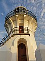
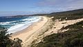
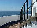
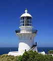
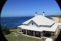
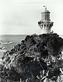
English: Sugarloaf Point Light is a heritage-listed lighthouse at Seal Rocks, New South Wales, Australia
lighthouse in New South Wales, Australia  | |||||
| Upload media | |||||
| Instance of | |||||
|---|---|---|---|---|---|
| Location | |||||
| Street address |
| ||||
| Architect | |||||
| Heritage designation |
| ||||
| Inception |
| ||||
| Area |
| ||||
 | |||||
Media in category "Sugarloaf Point Light"
The following 22 files are in this category, out of 22 total.
-
 1875 SugarLoaf Lighthouse - panoramio.jpg 2,736 × 3,648; 2.88 MB
-
 A view from Sugar Loaf Point Lighthouse.JPG 1,136 × 640; 199 KB
-

-
 Blue (16164736046).jpg 3,264 × 2,448; 1.61 MB
-
 Lighthouse Beach, below Sugarloaf Point Lighthouse.jpg 4,436 × 2,957; 3.08 MB
-
 Lighthouse l - panoramio.jpg 4,000 × 3,000; 4.38 MB
-
 Lighthouse ll (Roman Numerals) - panoramio.jpg 4,000 × 3,000; 4.18 MB
-
 Lighthouse lll - panoramio.jpg 4,000 × 3,000; 4.16 MB
-
 Looking Northwards - panoramio.jpg 4,000 × 3,000; 4.32 MB
-
 Plan of Seal Rocks & Sugarloaf Point, 1873 cropped.jpg 1,760 × 2,538; 450 KB
-
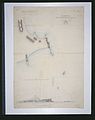 Plan of Seal Rocks & Sugarloaf Point, 1873.jpg 2,370 × 3,000; 236 KB
-
 Sugarloaf Point (15570751173).jpg 5,638 × 2,408; 4.26 MB
-
 Sugarloaf Point - panoramio.jpg 3,648 × 2,736; 1.67 MB
-
 Sugarloaf Point Lighthouse and rocks.jpg 4,653 × 3,102; 2.93 MB
-
 Sugarloaf Point Lighthouse cropped.jpg 2,846 × 3,249; 1.68 MB
-
 Sugarloaf Point Lighthouse heritage house.jpg 4,752 × 3,168; 4.15 MB
-
 Sugarloaf Point Lighthouse historic 2.jpg 670 × 872; 111 KB
-
 Sugarloaf Point Lighthouse historic.jpg 540 × 829; 60 KB
-
 Sugarloaf Point Lighthouse path.jpg 3,643 × 2,386; 4.79 MB
-
 Sugarloaf Point Lighthouse semaphore flag signal station.jpg 3,862 × 2,810; 2.14 MB
-
 Sugarloaf Point Lighthouse, 2007.jpg 2,592 × 1,944; 1.49 MB
-
 Sugarloaf Point Lighthouse.jpg 2,851 × 4,276; 2.59 MB


.jpg)


_-_panoramio.jpg)


.jpg)


