Category:Sunbury-on-Thames
Jump to navigation
Jump to search
town in Surrey, England, UK  Thames Street in Sunbury.  | |||||
| Upload media | |||||
| Instance of | |||||
|---|---|---|---|---|---|
| Location | Spelthorne, Surrey, South East England, England | ||||
| Located in or next to body of water | |||||
| Population |
| ||||
| Area |
| ||||
 | |||||
English: Sunbury-on-Thames, also known as Sunbury, is town in the Surrey borough of Spelthorne, England, and part of the London commuter belt. It is centred 16 miles (25 km) southwest of central London and bordered by Ashford Common, Feltham, Hampton, Shepperton, Upper Halliford and flanked on the south by the River Thames.
Français : Sunbury-on-Thames est une ville de la banlieue de Londres en Angleterre. Elle est située dans le borough de Spelthorne dans le comté de Surrey, à 25 km au sud-ouest du centre Londres. Elle est voisine de Hampton, bordée au sud par la Tamise.
Italiano: Sunbury-on-Thames è una cittadina di 27.415 abitanti della contea del Surrey, in Inghilterra.
Nederlands: Sunbury-on-Thames is een plaats in het bestuurlijke gebied Spelthorne, in het Engelse graafschap Surrey. De plaats telt 27.415 inwoners.
Simple English: Sunbury-on-Thames is a town in Surrey, England, UK. It is not far from the border with Greater London. It is where the M3 motorway starts.
Subcategories
This category has the following 17 subcategories, out of 17 total.
B
C
- Charlton, Surrey (5 F)
I
K
- Kempton Park railway station (24 F)
L
M
- Maps of Sunbury-on-Thames (3 F)
P
R
S
- Sunbury Hoard (5 F)
U
W
Media in category "Sunbury-on-Thames"
The following 200 files are in this category, out of 335 total.
(previous page) (next page)-

-
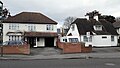
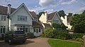
 1820's Semi-Detached House - geograph.org.uk - 4534611.jpg 918 × 1,632; 589 KB
-
 A308, Staines Road West, Sunbury - geograph.org.uk - 4482869.jpg 640 × 480; 273 KB
-
 Access Path - geograph.org.uk - 4542567.jpg 1,632 × 918; 349 KB
-
 Advertising display on Sundeala Close, Sunbury - geograph.org.uk - 5992187.jpg 1,280 × 1,920; 889 KB
-
 Allen Close off Allen Road - geograph.org.uk - 4857323.jpg 3,264 × 1,840; 1.39 MB
-
 Allen Road - Sunbury - geograph.org.uk - 4861348.jpg 3,264 × 1,840; 1.01 MB
-
 Anvil Road Burial Ground - geograph.org.uk - 4540191.jpg 1,632 × 918; 409 KB
-
 Approaching Upper Halliford - geograph.org.uk - 4676915.jpg 2,000 × 1,333; 2.82 MB
-
 Avenue Parade - geograph.org.uk - 5866080.jpg 1,024 × 768; 246 KB
-
 Backwater behind Grand Junction Island - geograph.org.uk - 4717832.jpg 640 × 427; 118 KB
-
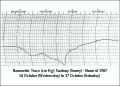 Baragraph Storm October 1987.svg 1,443 × 1,039; 333 KB
-
 Batavia Road - geograph.org.uk - 4858744.jpg 3,264 × 1,840; 1.16 MB
-
 Batavia Road - geograph.org.uk - 5865593.jpg 1,024 × 768; 237 KB
-
 Batavia Road - Sunbury - geograph.org.uk - 4860003.jpg 1,916 × 1,016; 592 KB
-
 Batavia Road Flats - geograph.org.uk - 4046368.jpg 1,277 × 718; 194 KB
-
 Batavia Road junction with Allen Road - geograph.org.uk - 4860152.jpg 3,264 × 1,840; 1.36 MB
-
 Beasley's Ait Lane - geograph.org.uk - 4547047.jpg 1,632 × 918; 427 KB
-
 Belgrave Crescent - geograph.org.uk - 4891875.jpg 3,264 × 1,840; 2.33 MB
-
 Belgrave Road - geograph.org.uk - 4891880.jpg 3,264 × 1,840; 2.46 MB
-
 Blacksmith Close - New Development - geograph.org.uk - 5863486.jpg 4,160 × 3,120; 3.92 MB
-
 Boat houses on Rivermead Island - geograph.org.uk - 5855885.jpg 1,024 × 768; 249 KB
-
 Bowater Gardens - geograph.org.uk - 4026387.jpg 3,072 × 1,728; 2.21 MB
-
 BP Filling Station, Kempton Park - geograph.org.uk - 4483059.jpg 640 × 480; 320 KB
-
 Brackenwood - Sunbury - geograph.org.uk - 4900956.jpg 3,264 × 1,840; 2.49 MB
-
 Bramwell Close - geograph.org.uk - 4039561.jpg 3,072 × 1,728; 1.87 MB
-
 Bramwell Close - geograph.org.uk - 4046720.jpg 1,277 × 718; 310 KB
-
 Broomfield - Sunbury - geograph.org.uk - 4901221.jpg 3,264 × 1,840; 2.72 MB
-
 Bus Stop Green Street - geograph.org.uk - 4514569.jpg 1,632 × 918; 458 KB
-
 Cattle Graving in Sunbury Park - geograph.org.uk - 5062667.jpg 3,264 × 1,840; 2.74 MB
-
 Cedar Trees at Sunbury Park - geograph.org.uk - 4870864.jpg 1,840 × 3,264; 2.5 MB
-
 Cedars Recreation Ground - Green Street - geograph.org.uk - 4517643.jpg 1,632 × 918; 568 KB
-
 Cedars Recreational Grounds - Mature Trees - geograph.org.uk - 4906859.jpg 3,264 × 1,840; 2 MB
-
 Cedars Recreational Grounds - Northern Entrance - geograph.org.uk - 4906919.jpg 3,264 × 1,840; 3.25 MB
-
 Cedars Recreational Grounds - Pavilion - geograph.org.uk - 4906853.jpg 3,264 × 1,840; 1.88 MB
-
 Cedars Recreational Grounds - Sunbury - geograph.org.uk - 4906842.jpg 3,264 × 1,840; 2.48 MB
-
 Cedars Recreational Grounds - Sunbury - geograph.org.uk - 4906846.jpg 3,264 × 1,840; 1.85 MB
-
 Cemetery Notice Board - geograph.org.uk - 4540169.jpg 1,632 × 918; 606 KB
-
 Chestnut Trees in Kempton Park Nature Reserve - geograph.org.uk - 2628863.jpg 2,048 × 1,536; 1.43 MB
-
 Clock Tower, Sunbury Common - geograph.org.uk - 3225689.jpg 430 × 640; 61 KB
-

-

-

-

-
 Country Way looking towards Sunbury Roundabout - geograph.org.uk - 5990497.jpg 1,872 × 1,204; 1.19 MB
-
 Croysdale Avenue - geograph.org.uk - 4513716.jpg 1,632 × 918; 422 KB
-
 Croysdale Avenue - geograph.org.uk - 4875559.jpg 3,264 × 1,840; 1.94 MB
-
 Cycle and Footpath - geograph.org.uk - 4870876.jpg 3,264 × 1,840; 2.89 MB
-
 Cycle and Footpath - geograph.org.uk - 4882564.jpg 3,264 × 1,840; 2.25 MB
-
 Darby Gardens - geograph.org.uk - 4038403.jpg 3,072 × 1,728; 1.86 MB
-
 Decorated subway by the Sunbury Roundabout - geograph.org.uk - 4838114.jpg 2,304 × 1,728; 935 KB
-
 Eastern End of the Reservoir - geograph.org.uk - 4537120.jpg 1,632 × 918; 566 KB
-

-
 Elmbrook Close of The Avenue - geograph.org.uk - 4891860.jpg 3,264 × 1,840; 3.39 MB
-
 End of Nursery Road - geograph.org.uk - 6105955.jpg 5,120 × 2,560; 5 MB
-
 End of Path - geograph.org.uk - 4026359.jpg 1,728 × 3,072; 2.03 MB
-
 End of Silverdale Drive - geograph.org.uk - 4871048.jpg 3,264 × 1,840; 1.95 MB
-
 End of the Road - geograph.org.uk - 4036517.jpg 3,072 × 1,728; 2.04 MB
-
 Entrance to Chennestone School - geograph.org.uk - 4862138.jpg 3,264 × 1,840; 1.35 MB
-
 Fairlawns off Croysdale Avenue - geograph.org.uk - 4875491.jpg 3,264 × 1,840; 3.07 MB
-
 Farm outbuildings, Vicarage Farm - geograph.org.uk - 3841262.jpg 1,024 × 759; 158 KB
-
 Field between the River Ash and the River Thames - geograph.org.uk - 5870103.jpg 1,024 × 768; 231 KB
-
 Field Next to the Graveyard - geograph.org.uk - 4537131.jpg 1,632 × 918; 448 KB
-
 Fields near Sunbury - geograph.org.uk - 4537032.jpg 1,632 × 918; 435 KB
-
 Flats - geograph.org.uk - 4547010.jpg 1,632 × 918; 374 KB
-
 Footbridge, A316 - geograph.org.uk - 4530224.jpg 640 × 426; 58 KB
-
 Footbridge, A316 - geograph.org.uk - 5038958.jpg 640 × 426; 37 KB
-
 Footbridge, A316 - geograph.org.uk - 5103007.jpg 640 × 427; 49 KB
-
 Footbridge, A316 - geograph.org.uk - 5848519.jpg 1,024 × 681; 111 KB
-
 Footpath between Maryland Way and Manor Lane - geograph.org.uk - 4860007.jpg 3,264 × 1,840; 1.12 MB
-
 Footpath in Sunbury - geograph.org.uk - 4834975.jpg 3,264 × 1,840; 1.98 MB
-
 Fordbridge Road - geograph.org.uk - 4546995.jpg 1,632 × 918; 423 KB
-
 Fordbridge Road - geograph.org.uk - 4547037.jpg 1,632 × 918; 418 KB
-
 Fordbridge Road - geograph.org.uk - 5870058.jpg 1,024 × 768; 257 KB
-
 Forge Lane - geograph.org.uk - 4540187.jpg 1,632 × 918; 524 KB
-
 Forge Lane - geograph.org.uk - 4540286.jpg 1,632 × 918; 469 KB
-
 Forge Lane - geograph.org.uk - 4540290.jpg 1,632 × 918; 459 KB
-
 Gate into gardens at Sunbury - geograph.org.uk - 4717830.jpg 640 × 427; 131 KB
-
 Green pathway at The Avenue - geograph.org.uk - 4717825.jpg 640 × 427; 112 KB
-
 Green Street - geograph.org.uk - 4513740.jpg 1,632 × 918; 443 KB
-
 Green Street - geograph.org.uk - 4516644.jpg 1,632 × 918; 491 KB
-
 Green Street - geograph.org.uk - 4517654.jpg 1,632 × 918; 455 KB
-
 Green Street - geograph.org.uk - 4874072.jpg 1,840 × 3,264; 1.72 MB
-
 Green Street - Sunbury on Thames - geograph.org.uk - 4874183.jpg 3,264 × 1,840; 2.21 MB
-
 Green Way - geograph.org.uk - 4540175.jpg 1,632 × 918; 361 KB
-
 Griffin Way Junction with Manor Lane - geograph.org.uk - 4871068.jpg 3,264 × 1,840; 1.79 MB
-
 Haliford Road - Sunbury - geograph.org.uk - 4939647.jpg 3,264 × 1,840; 2.14 MB
-
 Halliford Road close to Green Way - geograph.org.uk - 5292670.jpg 4,608 × 3,456; 6.75 MB
-
 Halliford Road close to Tadmore Close - geograph.org.uk - 5292663.jpg 4,608 × 3,456; 5.82 MB
-
 Hanworth Road by Country Way, Sunbury - geograph.org.uk - 5993137.jpg 1,920 × 1,280; 1.35 MB
-
 Hanworth Road, Sunbury - geograph.org.uk - 5992139.jpg 1,920 × 1,280; 816 KB
-
 Hawkedale Infants School Entrance - geograph.org.uk - 4874160.jpg 3,264 × 1,840; 2.14 MB
-
 Hawkewood Road - geograph.org.uk - 4872794.jpg 3,264 × 1,840; 2.54 MB
-
 Hawkewood Road - geograph.org.uk - 4872801.jpg 3,264 × 1,840; 1.81 MB
-
 Hawkewood Road - geograph.org.uk - 4872805.jpg 3,264 × 1,840; 2.34 MB
-
 Hawkewood Road Junction with The Pines - geograph.org.uk - 4872807.jpg 3,264 × 1,840; 1.91 MB
-
 Hawkewood Road near Green Street - geograph.org.uk - 4872815.jpg 3,264 × 1,840; 1.97 MB
-
 Heathcroft Avenue, Sunbury - geograph.org.uk - 5990500.jpg 1,920 × 1,280; 1.56 MB
-
 Heathcroft Avenue, Sunbury - geograph.org.uk - 5990502.jpg 1,280 × 1,920; 1.59 MB
-
 Heathlands Close - geograph.org.uk - 6100682.jpg 3,648 × 1,824; 2.88 MB
-
 Historic Path - Rope Walk - geograph.org.uk - 4025672.jpg 3,072 × 1,728; 2.31 MB
-
 Holiday Homes Converted - geograph.org.uk - 4025188.jpg 3,072 × 1,728; 1.78 MB
-
 Horse Farm on edge of Sunbury - geograph.org.uk - 4906911.jpg 3,264 × 1,840; 2.08 MB
-
 Horse Track Near Stadium - geograph.org.uk - 6046406.jpg 3,648 × 2,736; 6.37 MB
-
 Horses in a field east of Fordbridge Road - geograph.org.uk - 5870062.jpg 1,024 × 768; 229 KB
-
 House in Ravenscourt Cul-de-sac - geograph.org.uk - 6105965.jpg 3,648 × 1,824; 3.09 MB
-
 House in Thames Street - geograph.org.uk - 5868407.jpg 1,024 × 768; 359 KB
-
 House on Lower Hampton Road - geograph.org.uk - 4045908.jpg 640 × 427; 84 KB
-
-

-
 Houses in Church Street - geograph.org.uk - 6240030.jpg 640 × 480; 84 KB
-
 Houses in Thames Street - geograph.org.uk - 6123227.jpg 640 × 480; 82 KB
-
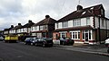
 Houses on Manor Lane - geograph.org.uk - 4865100.jpg 3,264 × 1,840; 1.08 MB
-
 Houses on Manor Lane - geograph.org.uk - 4870241.jpg 3,264 × 1,840; 1.07 MB
-
 Houses on Manor Lane - geograph.org.uk - 4870246.jpg 3,264 × 1,840; 936 KB
-
 Island Dwellings - geograph.org.uk - 4414478.jpg 1,280 × 720; 320 KB
-
 J1, M3 - geograph.org.uk - 5038956.jpg 640 × 446; 43 KB
-
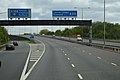 Junction 1, M3 - geograph.org.uk - 4530194.jpg 640 × 426; 56 KB
-

-
 Kempton Park - geograph.org.uk - 4046584.jpg 1,277 × 718; 190 KB
-
 Kempton Park - geograph.org.uk - 4046595.jpg 1,277 × 718; 191 KB
-
 Kempton Park - geograph.org.uk - 4063082.jpg 1,600 × 900; 249 KB
-
 Kempton Park Buildings - geograph.org.uk - 6051934.jpg 3,648 × 2,736; 4.96 MB
-
 Kempton Park Race Course - geograph.org.uk - 4044302.jpg 3,072 × 1,728; 1.14 MB
-
 Kempton Park Race Course - geograph.org.uk - 4046571.jpg 1,277 × 718; 195 KB
-
 Kempton Park Racecourse - geograph.org.uk - 3918799.jpg 1,024 × 586; 143 KB
-
 Kempton Park Racecourse - geograph.org.uk - 4046336.jpg 1,600 × 900; 183 KB
-
 Kempton Park Racecourse station, 2005 - geograph.org.uk - 5435968.jpg 2,268 × 1,344; 3.08 MB
-
 Kempton Park Southern Boundary - geograph.org.uk - 4058697.jpg 1,277 × 718; 203 KB
-
 Kempton Park station (2) - geograph.org.uk - 5865568.jpg 1,024 × 768; 197 KB
-
 Kenton Avenue - geograph.org.uk - 4042885.jpg 3,072 × 1,728; 2.23 MB
-
 Kenton Avenue - geograph.org.uk - 4042974.jpg 3,072 × 1,728; 2 MB
-
 Kenton Court Meadow Sports Complex - geograph.org.uk - 4046609.jpg 1,277 × 718; 228 KB
-
 Kenton Court Meadows - geograph.org.uk - 4042860.jpg 1,024 × 576; 164 KB
-
 Kingston Road, Sunbury - geograph.org.uk - 4838116.jpg 2,304 × 1,728; 818 KB
-
 Laburnum Crescent of Batavia Road - Sunbury - geograph.org.uk - 4891869.jpg 3,264 × 1,840; 2.79 MB
-
 Large Detached House - geograph.org.uk - 4029368.jpg 3,072 × 1,728; 1.77 MB
-
 Large Detached House - geograph.org.uk - 4042981.jpg 3,072 × 1,728; 1.65 MB
-
 Local Theme Mosaic - geograph.org.uk - 4516192.jpg 973 × 918; 992 KB
-
 London Irish Rugby Club Car Park - geograph.org.uk - 4542403.jpg 1,632 × 918; 341 KB
-
 London Irish Rugby Ground - geograph.org.uk - 4675735.jpg 2,000 × 1,333; 1.86 MB
-
 Looking Across to Lower Sunbury Houses - geograph.org.uk - 4537108.jpg 1,632 × 918; 593 KB
-

-

-
 Lower Hampton Road - geograph.org.uk - 4042789.jpg 3,072 × 1,728; 1.69 MB
-
 Lower Sunbury - geograph.org.uk - 4533190.jpg 1,632 × 918; 448 KB
-
 Lyndhurst Avenue - geograph.org.uk - 4875538.jpg 3,264 × 1,840; 1.85 MB
-
 Lyndhurst Avenue - geograph.org.uk - 4875542.jpg 3,264 × 1,840; 1.92 MB
-
 Making a New Reservoir - geograph.org.uk - 4537091.jpg 1,632 × 918; 504 KB
-
 Manor Drive - geograph.org.uk - 6100666.jpg 3,648 × 1,824; 2.89 MB
-
 Manor Lane - Detached Houses - geograph.org.uk - 4870259.jpg 3,264 × 1,840; 934 KB
-
 Manor Lane - Entrance to St Paul's College - geograph.org.uk - 4870238.jpg 3,264 × 1,840; 1,005 KB
-
 Manor Lane - Sunbury on Thames - geograph.org.uk - 4868561.jpg 3,264 × 1,840; 1,019 KB
-
 Martingale Close - geograph.org.uk - 4540178.jpg 1,632 × 918; 379 KB
-
 Maryland Way - geograph.org.uk - 4869059.jpg 3,264 × 1,840; 1.32 MB
-
 Maryland Way - geograph.org.uk - 4871057.jpg 3,264 × 1,840; 1.87 MB
-
 Maryland Way - geograph.org.uk - 4871061.jpg 3,264 × 1,840; 1.44 MB
-
 Maryland Way - geograph.org.uk - 4871064.jpg 3,264 × 1,840; 1.69 MB
-
 Mast by the M3 - geograph.org.uk - 4561255.jpg 426 × 640; 50 KB
-
 Mature Trees in Sunbury Park - geograph.org.uk - 4425537.jpg 1,280 × 720; 477 KB
-
 Mayland Way - geograph.org.uk - 4865888.jpg 3,264 × 1,840; 1.05 MB
-
 Middle Thames Yacht Club, Sunburylock Ait (2) - geograph.org.uk - 5868417.jpg 1,024 × 768; 207 KB
-
 Middle Thames Yacht Club, Sunburylock Ait - geograph.org.uk - 5868411.jpg 1,024 × 768; 231 KB
-
 Modern Flats on Green Street - geograph.org.uk - 6010484.jpg 4,160 × 3,120; 3.7 MB
-
 Modern Three Storey Terraces - geograph.org.uk - 4042895.jpg 3,072 × 1,728; 1.59 MB
-
 Montford Road - End of Road - geograph.org.uk - 4939654.jpg 3,264 × 1,840; 2.49 MB
-
 Montford Road - Sunbury - geograph.org.uk - 4939650.jpg 3,264 × 1,840; 2.49 MB
-
 Muddy path, Upper Halliford - geograph.org.uk - 4676885.jpg 2,000 × 1,333; 3.12 MB
-
 Mural at Sunbury Cross M3 subway - geograph.org.uk - 2491691.jpg 480 × 640; 91 KB
-
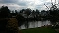
 New Pond - geograph.org.uk - 4537055.jpg 1,632 × 918; 386 KB
-

-
 Nursery Gardens - geograph.org.uk - 6103477.jpg 5,120 × 2,560; 5.5 MB
-
 Oak Grove - Sunbury - geograph.org.uk - 4900909.jpg 1,916 × 1,080; 1.39 MB
-
 Old Public Footpath - geograph.org.uk - 4542571.jpg 1,632 × 918; 501 KB
-
 Old Rope Walk, The Avenue (2) - geograph.org.uk - 5866065.jpg 768 × 1,024; 335 KB
-
 Old Rope Walk, The Avenue - geograph.org.uk - 5866062.jpg 768 × 1,024; 321 KB
-

-
 Open Garden Area of Sunbury Court - geograph.org.uk - 4046791.jpg 1,277 × 718; 187 KB
-
 Park Avenue - Sunbury - geograph.org.uk - 4891813.jpg 3,264 × 1,840; 1.92 MB
-
 Park Avenue Development - geograph.org.uk - 4835468.jpg 3,264 × 1,840; 2.52 MB
-
 Park Avenue Development - geograph.org.uk - 4891800.jpg 3,264 × 1,840; 2.17 MB
-
 Park Avenue Housing Estate nearly finished in Sunbury - geograph.org.uk - 4819454.jpg 3,989 × 1,585; 1.01 MB
-
 Park Road - geograph.org.uk - 5865575.jpg 1,024 × 768; 239 KB
-
 Park Road - Sunbury - geograph.org.uk - 4936086.jpg 3,235 × 1,746; 4.99 MB
-
 Park Road - Sunbury - geograph.org.uk - 4936098.jpg 3,264 × 1,734; 4.02 MB
-
 Park Road, Sunbury - geograph.org.uk - 5993129.jpg 1,920 × 1,280; 1.44 MB
-
 Park Road, Sunbury - geograph.org.uk - 5993133.jpg 1,920 × 1,280; 1.74 MB
-
 Parkwood Grove off Croysdale Avenue - geograph.org.uk - 4875507.jpg 3,264 × 1,840; 2.34 MB
-
 Passageway south of Thames Street - geograph.org.uk - 5868368.jpg 1,024 × 768; 339 KB
-
-
 Path between The Avenue and French Street - geograph.org.uk - 5865601.jpg 1,024 × 768; 263 KB
-
 Path between The Avenue and French Street - geograph.org.uk - 5865609.jpg 1,024 × 768; 275 KB
-
 Path between The Avenue and Green Street - geograph.org.uk - 5865614.jpg 1,024 × 768; 243 KB
-
 Path through gardens at Sunbury - geograph.org.uk - 4717831.jpg 640 × 427; 120 KB
-
 Peeping out into the Thames - geograph.org.uk - 4717837.jpg 640 × 427; 105 KB
-
 Pinewood - Sunbury - geograph.org.uk - 4901232.jpg 3,264 × 1,840; 1.84 MB
-
 Plate showing the floodmark in 1894 - geograph.org.uk - 3543187.jpg 800 × 600; 206 KB
-

-

-
 Pond near Upper Halliford - geograph.org.uk - 4676889.jpg 2,000 × 1,333; 2.51 MB
_sign_for_the_White_Horse,_Thames_Street_-_geograph.org.uk_-_5868398.jpg)


_-_geograph.org.uk_-_5868357.jpg)


_-_geograph.org.uk_-_5865568.jpg)


_-_geograph.org.uk_-_5868417.jpg)


_-_geograph.org.uk_-_5866065.jpg)


_-_geograph.org.uk_-_5870136.jpg)

