Category:Sundial at St Peter's church, Heswall
Jump to navigation
Jump to search
| Object location | | View all coordinates using: OpenStreetMap |
|---|
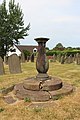
Grade II listed stone sundial dating to 1726. Stone. Of baluster form on two circular steps. Its original octagonal plate and gnomon are no longer present.
Grade II listed sundial in Heswall, Merseyside, UK  | |||||
| Upload media | |||||
| Instance of | |||||
|---|---|---|---|---|---|
| Location | St Peter's Church, Heswall, Heswall, Wirral, Merseyside, North West England, England | ||||
| Heritage designation |
| ||||
| Inception |
| ||||
| Adjacent building | |||||
 | |||||
Media in category "Sundial at St Peter's church, Heswall"
The following 5 files are in this category, out of 5 total.
-
 Sundial at St Peter's Church, Heswall 01.jpg 4,078 × 3,104; 3.69 MB
-
 Sundial at St Peter's Church, Heswall 02.jpg 4,000 × 3,000; 4.34 MB
-
 Sundial at St Peter's church, Heswall 1.jpg 3,456 × 5,184; 14.66 MB
-
 Sundial at St Peter's church, Heswall 2.jpg 3,210 × 4,926; 9.66 MB
-
 Sundial at St Peter's church, Heswall 3.jpg 3,456 × 5,184; 13.09 MB


