Category:Sutton upon Tern
Jump to navigation
Jump to search
village and civil parish in Shropshire, United Kingdom  | |||||
| Upload media | |||||
| Instance of | |||||
|---|---|---|---|---|---|
| Location | Shropshire, West Midlands, England | ||||
 | |||||
Subcategories
This category has the following 4 subcategories, out of 4 total.
Media in category "Sutton upon Tern"
The following 107 files are in this category, out of 107 total.
-
 'Spirit of Phoebe' at Tyrley Wharf - geograph.org.uk - 5420626.jpg 1,280 × 851; 508 KB
-
 A41 at Ad Astra services - geograph.org.uk - 2775596.jpg 640 × 480; 46 KB
-
 A41 at RAF Tern Hill - geograph.org.uk - 2775589.jpg 640 × 480; 37 KB
-

-
 A41 crosses the River Tern - geograph.org.uk - 2775597.jpg 640 × 480; 45 KB
-
 A41 north of Tern Hill roundabout - geograph.org.uk - 2775600.jpg 640 × 480; 39 KB
-

-
 A529 junction at Woodseaves - geograph.org.uk - 1829182.jpg 640 × 480; 75 KB
-
 A529 towards Hinstock - geograph.org.uk - 6261939.jpg 800 × 600; 113 KB
-
 A529 towards Market Drayton - geograph.org.uk - 6261905.jpg 800 × 600; 182 KB
-
 A529, Woodseaves - geograph.org.uk - 6261943.jpg 640 × 480; 101 KB
-
 Barns at Colehurst Manor Farm - geograph.org.uk - 4904068.jpg 1,200 × 820; 336 KB
-
 Bridge over River Tern - geograph.org.uk - 787437.jpg 640 × 480; 263 KB
-

-
 Buzzard On The Shropshire Union Canal - geograph.org.uk - 2893657.jpg 4,000 × 2,248; 3.37 MB
-

-
 Canal in Woodseaves Cutting, Shropshire - geograph.org.uk - 5287193.jpg 1,600 × 1,200; 1,007 KB
-
 Cattle near Woodseaves Manor Farm - geograph.org.uk - 6261944.jpg 800 × 600; 108 KB
-

-
 Dank and dreary Woodseaves Cutting - geograph.org.uk - 5457703.jpg 640 × 480; 101 KB
-
 Domesday Book entry.png 718 × 221; 77 KB
-
 Field entrance off Sutton Lane - geograph.org.uk - 6261924.jpg 800 × 600; 105 KB
-
 Field entrance off Sutton Lane - geograph.org.uk - 6261931.jpg 800 × 600; 141 KB
-
 Fields from the canal tow-path - geograph.org.uk - 2924109.jpg 640 × 480; 105 KB
-

-
 Grazing and hedgerow, Woodseaves - geograph.org.uk - 6261941.jpg 800 × 600; 185 KB
-
 Grazing near Market Drayton - geograph.org.uk - 6261906.jpg 800 × 600; 86 KB
-
 Haywood Lane - geograph.org.uk - 5457753.jpg 640 × 480; 78 KB
-
 Haywood Lane - geograph.org.uk - 6261947.jpg 800 × 600; 134 KB
-
 Healthy crop of rape - geograph.org.uk - 786698.jpg 640 × 480; 319 KB
-
 High Bridge 57 Shropshire Union Canal - geograph.org.uk - 3386442.jpg 1,400 × 2,097; 1.22 MB
-
 High Bridge in Woodseaves Cutting, Shropshire - geograph.org.uk - 6035199.jpg 1,080 × 1,440; 2.44 MB
-
 High Bridge in Woodseaves Cutting, Shropshire - geograph.org.uk - 6035201.jpg 1,080 × 1,440; 2.24 MB
-
 High Bridge, Woodseaves Cutting - geograph.org.uk - 5457735.jpg 480 × 640; 97 KB
-
 High Bridge, Woodseaves Cutting - geograph.org.uk - 5457744.jpg 480 × 640; 81 KB
-
 House on Sutton Lane - geograph.org.uk - 6261933.jpg 800 × 600; 134 KB
-
 Houses on Sutton Lane - geograph.org.uk - 6261929.jpg 800 × 600; 174 KB
-
 Houses on Sutton Lane - geograph.org.uk - 6261935.jpg 800 × 600; 153 KB
-
 Houses on Tyrley Road - geograph.org.uk - 6261895.jpg 800 × 600; 93 KB
-
 In Tyrley Locks - geograph.org.uk - 4599866.jpg 640 × 427; 97 KB
-
 Land alongside the A53 - geograph.org.uk - 4675052.jpg 800 × 451; 182 KB
-
 Large wagon on the Tyrley Road - geograph.org.uk - 5129291.jpg 1,600 × 901; 712 KB
-
 Lockside view at Tyrley top lock - geograph.org.uk - 4599850.jpg 640 × 427; 89 KB
-
 Milepost, Shropshire Union Canal.jpg 640 × 480; 146 KB
-
 Miscanthus for Biofuel, 1 - geograph.org.uk - 5129279.jpg 1,600 × 901; 718 KB
-
 Miscanthus for Biofuel, 2 - geograph.org.uk - 5129280.jpg 1,600 × 901; 726 KB
-
 Mortimer Road - geograph.org.uk - 3215797.jpg 640 × 480; 126 KB
-

-

-
 Navigating the Woodseaves Cutting - geograph.org.uk - 5457721.jpg 640 × 480; 109 KB
-
 Newport Road (A529) - geograph.org.uk - 6261903.jpg 800 × 600; 193 KB
-
 Old Colehurst Manor - geograph.org.uk - 4904072.jpg 1,200 × 816; 248 KB
-
 Old Colehurst Manor - geograph.org.uk - 581787.jpg 640 × 480; 128 KB
-
 Old Direction Sign - Signpost by the A529, Woodseaves - geograph.org.uk - 6083910.jpg 1,200 × 1,600; 271 KB
-

-
 Old railway embankment - geograph.org.uk - 4675061.jpg 800 × 483; 213 KB
-
 Old railway embankment at Ternhill - geograph.org.uk - 4675066.jpg 800 × 451; 201 KB
-
 Old Toll House, Woodseaves - geograph.org.uk - 6115195.jpg 800 × 534; 320 KB
-
 Pond at Rosehill - geograph.org.uk - 4904062.jpg 1,200 × 799; 259 KB
-
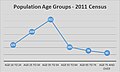 Population Groups for Sutton upon Tern (Parish).jpg 480 × 289; 30 KB
-
 Public footpath leading to Sutton Grange - geograph.org.uk - 4904080.jpg 1,200 × 799; 309 KB
-
 Public footpath to Sutton Grange - geograph.org.uk - 4904076.jpg 1,200 × 799; 270 KB
-
 Restricted Byway at Lower Sydnall - geograph.org.uk - 786765.jpg 640 × 480; 171 KB
-
 Restricted byway to Colehurst Manor - geograph.org.uk - 786684.jpg 640 × 480; 195 KB
-
 Rosehill Mill - geograph.org.uk - 786710.jpg 640 × 480; 294 KB
-
 Sandy Lane, Market Drayton - geograph.org.uk - 4904083.jpg 1,200 × 799; 516 KB
-
 Shropshire Union Canal at Tyrley Wharf - geograph.org.uk - 5106415.jpg 1,600 × 901; 915 KB
-
-

-
 Shropshire Union Canal near Woodseaves in Shropshire - geograph.org.uk - 5287237.jpg 1,440 × 1,920; 1.57 MB
-
 Shropshire Union Canal near Woodseaves, Shropshire - geograph.org.uk - 5287315.jpg 1,280 × 960; 1.32 MB
-
 Sign for the Four Alls - geograph.org.uk - 6261902.jpg 584 × 800; 90 KB
-
 Sutton Grange Farm - geograph.org.uk - 4904075.jpg 1,200 × 823; 281 KB
-
 Sutton Lane - geograph.org.uk - 6261928.jpg 800 × 600; 100 KB
-
 Sutton Lane - geograph.org.uk - 6261930.jpg 800 × 600; 197 KB
-
 Sutton Lane - geograph.org.uk - 6261934.jpg 800 × 600; 126 KB
-
 Sutton Lane junction with the A529 - geograph.org.uk - 6261938.jpg 800 × 600; 95 KB
-
 Sutton Lane towards the A529 - geograph.org.uk - 6261936.jpg 800 × 600; 130 KB
-
 Sutton upon Tern - Tyrley Canal Cutting - 20230824120721.jpeg 4,032 × 3,024; 4.7 MB
-
 Sutton upon Tern - Tyrley Canal Cutting - 20230824120809.jpeg 4,032 × 3,024; 2.43 MB
-
 The canal in Woodseaves Cutting, Shropshire - geograph.org.uk - 2800648.jpg 1,024 × 686; 593 KB
-

-

-
-
 The Four Alls - geograph.org.uk - 6261900.jpg 800 × 535; 97 KB
-
 The Mill House, Rosehill - geograph.org.uk - 4904060.jpg 1,200 × 799; 375 KB
-
 The Shroppy near Tyrley Castle Farm - geograph.org.uk - 4052408.jpg 1,142 × 857; 357 KB
-
 Tyrley Grange, Tyrley Road - geograph.org.uk - 2503451.jpg 640 × 463; 72 KB
-
 Tyrley Rd leading towards Tyrley Wharf near Market Drayton - geograph.org.uk - 5621943.jpg 5,184 × 2,920; 6.42 MB
-
 Tyrley Road - geograph.org.uk - 6261896.jpg 800 × 600; 142 KB
-
 Tyrley top lock 1 - geograph.org.uk - 3386430.jpg 2,069 × 1,413; 894 KB
-
 Tyrley Wharf buildings and top lock - geograph.org.uk - 4599830.jpg 640 × 427; 102 KB
-
 Tyrley Wharf on Shropshire Union Canal near Market Drayton - geograph.org.uk - 5621945.jpg 5,184 × 2,920; 1.52 MB
-
 View NW towards Lock 2, Tyrley Locks near Market Drayton - geograph.org.uk - 5621946.jpg 5,184 × 2,920; 5.94 MB
-
 Woodseaves Cutting - geograph.org.uk - 4236080.jpg 979 × 734; 449 KB
-
 Woodseaves Cutting - geograph.org.uk - 5457746.jpg 640 × 480; 101 KB
-

-

-

-

-

-
-
 Woodseaves Cutting south-east of Market Drayton, Shrosphire - geograph.org.uk - 6038554.jpg 1,440 × 1,080; 2.15 MB
-
 Woodseaves Miniature Railway - geograph.org.uk - 6227836.jpg 640 × 427; 138 KB
-
 Woodseaves Miniature Railway - geograph.org.uk - 6227902.jpg 640 × 427; 158 KB
-
 Woodseaves Miniature Railway - geograph.org.uk - 6227904.jpg 640 × 427; 129 KB
-
 Workmen negotiating Lock 4, Tyrley Locks near Market Drayton - geograph.org.uk - 5621947.jpg 5,184 × 2,920; 6.48 MB


,_Shropshire_Union_Canal,_Shropshire_-_geograph.org.uk_-_547748.jpg)


_-_geograph.org.uk_-_6261903.jpg)


.jpg)


