Category:Synagogue of Bad Homburg
Jump to navigation
Jump to search
| Object location | | View all coordinates using: OpenStreetMap |
|---|
 | |||||
| Upload media | |||||
| Instance of | |||||
|---|---|---|---|---|---|
| Location | Bad Homburg vor der Höhe, Hochtaunuskreis, Darmstadt Government Region, Hesse, Germany | ||||
| Inception |
| ||||
| Dissolved, abolished or demolished date |
| ||||
| Cause of destruction | |||||
 | |||||
Media in category "Synagogue of Bad Homburg"
The following 7 files are in this category, out of 7 total.
-
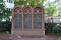 Bad Homburg, Synagogendenkmal.JPG 4,288 × 2,848; 6.98 MB
-
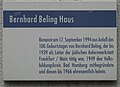
 Memorial Bad Homburg.jpg 700 × 356; 78 KB
-
 Nomination de l'université populaire de Bad Homburg.jpg 600 × 435; 57 KB
-
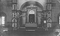 Syna Bad Homburg - inside.jpg 600 × 364; 36 KB
-
 Syna Homburg - Postcard.jpg 319 × 500; 32 KB
-
 Syna of Bad Homburg - Architect drawing.jpg 407 × 580; 207 KB
-
 Synagogue Bad Homburg.jpg 341 × 469; 112 KB


