Category:TIF versions of Sanborn maps of Manhattan published in 1894
Jump to navigation
Jump to search
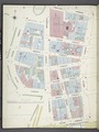
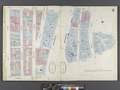
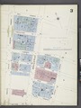
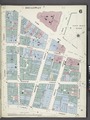
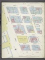
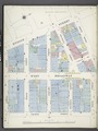
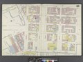
Maps from: Insurance Maps of the City of New York Surveyed and Published by Sanborn–Perris Map Co., Limited. Volume 1. (New York: 1894), comprising 35 maps (33 double-page plates, numbered 1–24, 24½, 25–30, and West Piers, and South Piers) plus title page, volume key, and street index. Plates No. 1, 3–9, 15–17, and 21–23 and West Piers and South Piers are each in two images (left half and right half).
Source: The New York Public Library Digital Collections website, Atlas 107. Vol. 1, 1894.
Media in category "TIF versions of Sanborn maps of Manhattan published in 1894"
The following 52 files are in this category, out of 52 total.
-

-
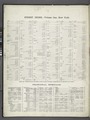 Index NYPL1992432.tiff 5,397 × 7,187, 2 pages; 111.04 MB
-
 Key NYPL1992433.tiff 5,384 × 7,163, 2 pages; 110.4 MB
-
 Manhattan, V. 1, Plate No. 1 west half (Map bounded by Beaver St., Broad St., South St., State St.) NYPL1992434.tiff 5,397 × 7,187, 2 pages; 111.04 MB
-
 Manhattan, V. 1, Plate No. 1 (Map bounded by Beaver St., Willim St., East River, Broad St.) NYPL1992435.tiff 5,384 × 7,163, 2 pages; 110.4 MB
-
-
 Manhattan, V. 1, Plate No. 3 west half (Map bounded by Dey St., Trinity Pl., Church St., Rector St., West St.) NYPL1992437.tiff 5,377 × 7,150, 2 pages; 110.05 MB
-
 Manhattan, V. 1, Plate No. 3 (Map bounded by Dey St., Nassau St., Rector St., Trinity Pl., Church St.) NYPL1992438.tiff 5,384 × 7,163, 2 pages; 110.4 MB
-
 Manhattan, V. 1, Plate No. 4 west half (Map bounded by Maidey Lane, Pearl St., Exchange Pl., Broad St.) NYPL1992439.tiff 5,377 × 7,150, 2 pages; 110.05 MB
-
 Manhattan, V. 1, Plate No. 4 (Map bounded by Maiden Lane, East River, Old Slip, Pearl St.) NYPL1992440.tiff 5,384 × 7,163, 2 pages; 110.4 MB
-
 Manhattan, V. 1, Plate No. 5 (Map bounded by Gold St., Dover St., Frankfort St., South St., Fulton St.) NYPL1992442.tiff 5,384 × 7,163, 2 pages; 110.4 MB
-
 Manhattan, V. 1, Plate No. 5 south half (Map bounded by Gold St., Beekman St., South St., Maiden Lane) NYPL1992441.tiff 5,377 × 7,150, 2 pages; 110.05 MB
-
 Manhattan, V. 1, Plate No. 6 (Map bounded by Broadway, Frankfort St., Gold St., Fulton St.) NYPL1992444.tiff 5,384 × 7,163, 2 pages; 110.4 MB
-
 Manhattan, V. 1, Plate No. 6 south half (Map bounded by Broadway, Fulton St., Gold St., Liberty St.) NYPL1992443.tiff 5,403 × 7,199, 2 pages; 111.34 MB
-
 Manhattan, V. 1, Plate No. 7 west half (Map bounded by Murray St., College Pl., Dey St., West St.) NYPL1992445.tiff 5,397 × 7,188, 2 pages; 111.05 MB
-
 Manhattan, V. 1, Plate No. 7 (Map bounded by Murray St., Broadway, Dey St., College Pl.) NYPL1992446.tiff 5,384 × 7,163, 2 pages; 110.4 MB
-
 Manhattan, V. 1, Plate No. 8 west half (Map bounded by Duane St., Murray St., West St.) NYPL1992447.tiff 5,397 × 7,188, 2 pages; 111.05 MB
-
 Manhattan, V. 1, Plate No. 8 (Map bounded by Thomas St., Church St., Murray St., Greenwich St.) NYPL1992448.tiff 5,384 × 7,163, 2 pages; 110.4 MB
-

-
 Manhattan, V. 1, Plate No. 9 (Map bounded by Pearl St., Rose St., Frankfort St., Elm St.) NYPL1992450.tiff 5,384 × 7,163, 2 pages; 110.4 MB
-

-
 Manhattan, V. 1, Double Page Plate No. 11 (Map bounded by Market St., East River, James St., East Broadway) NYPL1992452.tiff 7,191 × 5,399, 2 pages; 111.14 MB
-
 Manhattan, V. 1, Double Page Plate No. 12 (Map bounded by Rutgers St., East River, Market St., East Broadway) NYPL1992453.tiff 7,195 × 5,401, 2 pages; 111.24 MB
-

-
 Manhattan, V. 1, Double Page Plate No. 14 (Map bounded by Elm St., Canal St., Mott St., Park Row, Pearl St.) NYPL1992455.tiff 7,200 × 5,404, 2 pages; 111.38 MB
-
 Manhattan, V. 1, Plate No. 15 (Map bounded by Church St., Canal St., Elm St., Franklin St.) NYPL1992457.tiff 5,384 × 7,163, 2 pages; 110.4 MB
-
 Manhattan, V. 1, Plate No. 15 south half (Map bounded by Church St., Franklin St., Elm St., Pearl St., Thomas St.) NYPL1992456.tiff 5,382 × 7,158, 2 pages; 110.28 MB
-

-
-
 Manhattan, V. 1, Plate No. 17 (Map bounded by West St., Laight St., Varick St., North Moore St.) NYPL1992461.tiff 5,403 × 7,200, 2 pages; 111.36 MB
-
 Manhattan, V. 1, Plate No. 17 south half (Map bounded by West St., North Moore St., Hudson St., Duane St.) NYPL1992460.tiff 5,382 × 7,158, 2 pages; 110.28 MB
-
 Manhattan, V. 1, Double Page Plate No. 18 (Map bounded by Spring St., Clarke St., Sullivan St., Laight St., West St.) NYPL1992462.tiff 7,200 × 5,404, 2 pages; 111.38 MB
-
 Manhattan, V. 1, Double Page Plate No. 19 (Map bounded by W. Houston St., Varick St., Spring St., West St.) NYPL1992463.tiff 7,200 × 5,404, 2 pages; 111.38 MB
-

-
 Manhattan, V. 1, Plate No. 21 (Map bounded by Thompson St., Spring St., Broadway, Grand St.) NYPL1992466.tiff 5,403 × 7,200, 2 pages; 111.36 MB
-
 Manhattan, V. 1, Plate No. 21 south half (Map bounded by Thompson St., Grand St., Broadway, Canal St.) NYPL1992465.tiff 5,403 × 7,198, 2 pages; 111.33 MB
-
 Manhattan, V. 1, Plate No. 22 west half (Map bounded by W. Houston St., Wooster St., Spring St., Sullivan St.) NYPL1992467.tiff 5,403 × 7,198, 2 pages; 111.33 MB
-
 Manhattan, V. 1, Plate No. 22 (Map bounded by W. Houston St., Broadway, Spring St., Wooster St.) NYPL1992468.tiff 5,403 × 7,200, 2 pages; 111.36 MB
-
 Manhattan, V. 1, Plate No. 23 west half (Map bounded by Broome St., Baxter St., Canal St., Broadway) NYPL1992469.tiff 5,403 × 7,198, 2 pages; 111.33 MB
-
 Manhattan, V. 1, Plate No. 23 (Map bounded by Broome St., Bowery, Canal St., Baxter St.) NYPL1992470.tiff 5,403 × 7,200, 2 pages; 111.36 MB
-
 Manhattan, V. 1, Double Page Plate No. 24 (Map bounded by Broadway, E. Houston St., Bowery, Broome St., Elizabeth St.) NYPL1992471.tiff 7,200 × 5,404, 2 pages; 111.38 MB
-

-
 Manhattan, V. 1, Double Page Plate No. 25 (Map bounded by Rivington St., Essex St., Grand St., Bowery) NYPL1992473.tiff 7,200 × 5,404, 2 pages; 111.38 MB
-
 Manhattan, V. 1, Double Page Plate No. 26 (Map bounded by Essex St., Rivington St., Ridge St., Division St.) NYPL1992474.tiff 7,200 × 5,404, 2 pages; 111.38 MB
-

-

-

-
-
 Manhattan, V. 1, Plate No. South piers B (Map of south piers B.) NYPL1992482.tiff 5,403 × 7,200, 2 pages; 111.36 MB
-
 Manhattan, V. 1, Plate No. South piers A (Map of south piers A.) NYPL1992481.tiff 5,407 × 7,207, 2 pages; 111.55 MB
-
 Manhattan, V. 1, Plate No. West piers B (Map of west piers B.) NYPL1992480.tiff 5,403 × 7,200, 2 pages; 111.36 MB
-
 Manhattan, V. 1, Plate No. West piers A (Map of west piers A.) NYPL1992479.tiff 5,407 × 7,207, 2 pages; 111.55 MB