Category:Tandridge
Jump to navigation
Jump to search
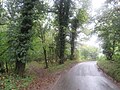
English: Tandridge is a village and civil parish in Surrey, England. It is located between Oxted and Godstone. For the Surrey district of the same name, see Category:Tandridge (district).
Nederlands: Tandridge is een plaats in het bestuurlijke gebied Tandridge, in het Engelse graafschap Surrey. De plaats telt inwoners.
village in Surrey, England, UK  | |||||
| Upload media | |||||
| Instance of | |||||
|---|---|---|---|---|---|
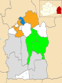
| Location | Tandridge, Surrey, South East England, England | ||||
| Population |
| ||||
| Area |
| ||||
 | |||||
Subcategories
This category has only the following subcategory.
S
Media in category "Tandridge"
The following 200 files are in this category, out of 228 total.
(previous page) (next page)-
 "I belong to TPRC RH8 9NE" - geograph.org.uk - 2248777.jpg 640 × 480; 138 KB
-
 2024 Tandridge District Council.svg 512 × 263; 8 KB
-
 A25 heading east - geograph.org.uk - 2702469.jpg 640 × 430; 74 KB
-
 A25 Oxted Road - geograph.org.uk - 1975233.jpg 640 × 426; 59 KB
-
 A25 Oxted Road - geograph.org.uk - 1975271.jpg 640 × 420; 80 KB
-
 Approaching access land at Blindley Heath - geograph.org.uk - 3490983.jpg 4,000 × 3,000; 4.76 MB
-
 Ardenrun - geograph.org.uk - 2977402.jpg 1,600 × 1,065; 455 KB
-
 Barn at Blackgrove Farm - geograph.org.uk - 2100739.jpg 3,264 × 2,448; 2.73 MB
-
 Barn, Old Hall Farm - geograph.org.uk - 6606584.jpg 1,024 × 685; 80 KB
-
 Barn, Tandridge Court Farm - geograph.org.uk - 2409402.jpg 640 × 430; 86 KB
-

-
 Blossom - geograph.org.uk - 1935670.jpg 681 × 1,024; 297 KB
-
 Bluebells, Round Wood - geograph.org.uk - 2410999.jpg 640 × 430; 166 KB
-
 Bricklayers Arms - geograph.org.uk - 3546676.jpg 640 × 419; 60 KB
-
 Brickmaker's Arms, Tandridge Lane - geograph.org.uk - 2265423.jpg 640 × 402; 75 KB
-
 Brickmakers Arms, Crowhurst - geograph.org.uk - 2100745.jpg 640 × 480; 96 KB
-
 Bridge over the Greensand Way - geograph.org.uk - 2410990.jpg 640 × 430; 107 KB
-
 Bungalow on Tandridge Lane - geograph.org.uk - 4667770.jpg 2,304 × 1,728; 843 KB
-
 Bungalow ^ Barn - geograph.org.uk - 4951215.jpg 640 × 426; 37 KB
-
 Bungalow ^ barn - geograph.org.uk - 5340044.jpg 640 × 426; 57 KB
-
 Buttercups in Bloom - geograph.org.uk - 2978283.jpg 4,592 × 3,056; 7.68 MB
-
 Car park in Knights Garden Centre, Oxted Road - geograph.org.uk - 2589529.jpg 1,600 × 1,200; 506 KB
-
 Corner of the A25 and Tandridge Lane - geograph.org.uk - 2587684.jpg 1,600 × 1,200; 561 KB
-
 Cottages at the junction - geograph.org.uk - 5565793.jpg 640 × 428; 108 KB
-
 Crowhurst Lane, Crowhurst - geograph.org.uk - 4323540.jpg 2,560 × 1,920; 2.9 MB
-
 Crowhurst Lane, Crowhurst - geograph.org.uk - 4323555.jpg 2,560 × 1,920; 2.61 MB
-

-

-
 Downland pasture south of Tandridge Priory - geograph.org.uk - 2792175.jpg 768 × 1,024; 151 KB
-
 Downland pasture west of Oxted, in January - geograph.org.uk - 2784121.jpg 1,024 × 767; 235 KB
-
 Driveway to Tandridge Hall - geograph.org.uk - 4408570.jpg 800 × 530; 632 KB
-
 Exit from Kinghts Garden Centre, Tandridge - geograph.org.uk - 2589532.jpg 1,600 × 1,200; 623 KB
-
 Fallow field - geograph.org.uk - 3369226.jpg 640 × 430; 57 KB
-
 Farmland east of Godstone - geograph.org.uk - 3358727.jpg 640 × 430; 31 KB
-
 Farmland east of the A22 - geograph.org.uk - 5193917.jpg 1,024 × 756; 136 KB
-
 Farmland near Oxted - geograph.org.uk - 4427564.jpg 640 × 513; 175 KB
-
 Field by M25 - geograph.org.uk - 5643012.jpg 640 × 426; 78 KB
-
 Field by Tandridge Lane, Blindley Heath - geograph.org.uk - 4673101.jpg 2,260 × 1,668; 1.24 MB
-
 Field by the M25 - geograph.org.uk - 4569216.jpg 640 × 426; 59 KB
-
 Field entrance on Ray Lane - geograph.org.uk - 4673077.jpg 2,304 × 1,728; 1.06 MB
-

-
 Fingerpost and stile - geograph.org.uk - 3492822.jpg 4,000 × 3,000; 3.38 MB
-
 Footbridge viewed from west side - geograph.org.uk - 3488793.jpg 4,000 × 3,000; 4.83 MB
-
 Footpath 253 on bridge - geograph.org.uk - 3488837.jpg 4,000 × 3,000; 4.38 MB
-
 Footpath junction to Southlands - geograph.org.uk - 4184349.jpg 4,320 × 3,240; 5.66 MB
-
 Footpath on North Downs - geograph.org.uk - 2948745.jpg 4,288 × 3,216; 5.72 MB
-
 Footpath to Ardenrun - geograph.org.uk - 3492835.jpg 4,000 × 3,000; 3.39 MB
-
 Footpath to Tandridge - geograph.org.uk - 2410983.jpg 640 × 430; 150 KB
-
 Footpath waymark, Greensand Way - geograph.org.uk - 2412533.jpg 640 × 430; 128 KB
-
 Gangers Hill, near Godstone - geograph.org.uk - 6303502.jpg 1,024 × 768; 287 KB
-
 Godstone, 'Safeguard' coaches depot - geograph.org.uk - 4196968.jpg 4,608 × 3,456; 6.14 MB
-
 Godstone, Knights Garden Centre - geograph.org.uk - 4196934.jpg 4,608 × 3,456; 6.42 MB
-
 Grave of Headly Willson - geograph.org.uk - 2931182.jpg 480 × 640; 205 KB
-
 Grazing land - geograph.org.uk - 6441616.jpg 1,024 × 681; 114 KB
-
 Greensand Way - geograph.org.uk - 2407141.jpg 640 × 430; 76 KB
-
 Greensand Way across Tandridge Park - geograph.org.uk - 2409396.jpg 640 × 430; 93 KB
-
 Greensand Way approaching Tandridge - geograph.org.uk - 2087451.jpg 2,816 × 2,112; 2.06 MB
-
 Greensand Way east of Tandridge - geograph.org.uk - 2410985.jpg 640 × 430; 132 KB
-
 Greensand Way in the trees - geograph.org.uk - 2411017.jpg 640 × 430; 136 KB
-
 Greensand Way leaves Tandridge - geograph.org.uk - 2409389.jpg 640 × 430; 128 KB
-
 Greensand Way to Tandridge - geograph.org.uk - 2407162.jpg 640 × 430; 72 KB
-
 Hogtrough Lane on Tandridge Hill - geograph.org.uk - 2948923.jpg 3,216 × 4,288; 6.92 MB
-
 House by Tandridge Lane - geograph.org.uk - 3369230.jpg 640 × 493; 71 KB
-
 House on Tandridge Lane - geograph.org.uk - 4667771.jpg 2,304 × 1,728; 857 KB
-
 Houses on Crowhurst Lane - geograph.org.uk - 2100749.jpg 640 × 427; 88 KB
-
 Houses on Crowhurst Lane - geograph.org.uk - 2265418.jpg 640 × 241; 56 KB
-
 Houses on Miles Lane, Chathill - geograph.org.uk - 4673103.jpg 2,242 × 1,642; 1.16 MB
-
 Houses on Miles Lane, Chathill - geograph.org.uk - 4673104.jpg 2,304 × 1,728; 843 KB
-
 Houses on Tandridge High St - geograph.org.uk - 2407170.jpg 640 × 430; 66 KB
-
 Jackass Lane - geograph.org.uk - 1934295.jpg 2,943 × 4,444; 7.55 MB
-
 Jackass Lane, Tandridge - geograph.org.uk - 2930617.jpg 1,024 × 768; 336 KB
-
 Kings Cottage, Tandridge - geograph.org.uk - 2409393.jpg 640 × 430; 91 KB
-
 Little Court Farm - geograph.org.uk - 4184317.jpg 4,320 × 3,240; 5.73 MB
-
 Lodge and start of drive to Southlands - geograph.org.uk - 5565736.jpg 640 × 428; 165 KB
-
 Lodge to Tandridge Hall - geograph.org.uk - 4408571.jpg 800 × 530; 480 KB
-
 Lych Gate to St. Peters Church, Tandridge - geograph.org.uk - 2087486.jpg 2,816 × 2,112; 2.39 MB
-
 M25 - geograph.org.uk - 1975185.jpg 640 × 426; 80 KB
-
 M25 anti clockwise - geograph.org.uk - 2508812.jpg 640 × 480; 66 KB
-
 M25 anti-clockwise - geograph.org.uk - 2507021.jpg 640 × 427; 72 KB
-
 M25 east of Flower Lane - geograph.org.uk - 2236610.jpg 640 × 480; 78 KB
-
 M25 half mile to junction 6, the A22 - geograph.org.uk - 3599618.jpg 2,457 × 1,467; 1.77 MB
-
 M25 viewed from Tandridgehill Lane - geograph.org.uk - 5847140.jpg 1,600 × 994; 205 KB
-
 M25, Tandridge Hill Lane overbridge - geograph.org.uk - 2033816.jpg 640 × 430; 110 KB
-
 Maizenhill Shaw - geograph.org.uk - 2412527.jpg 640 × 430; 151 KB
-
 Mast in trees - geograph.org.uk - 4569223.jpg 640 × 426; 73 KB
-

-
 Miles Lane at the junction of Tandridge Lane - geograph.org.uk - 4323700.jpg 2,560 × 1,920; 1.97 MB
-
 Miles Lane, South Godstone - geograph.org.uk - 4673105.jpg 2,260 × 1,629; 941 KB
-
 Milestone, Oxted Road - geograph.org.uk - 1975260.jpg 426 × 640; 125 KB
-
 New Barn - geograph.org.uk - 6485729.jpg 1,024 × 621; 136 KB
-
 New Bungalow and Barn - geograph.org.uk - 4792680.jpg 640 × 426; 46 KB
-
 New Road at the junction of Miles Lane - geograph.org.uk - 4673106.jpg 2,304 × 1,728; 830 KB
-
 New Road, north of South Godstone - geograph.org.uk - 2758443.jpg 640 × 480; 58 KB
-
 North Downs Way crosses Gangers Hill - geograph.org.uk - 2949034.jpg 4,288 × 3,216; 6.47 MB
-
 Not a tree - geograph.org.uk - 2248789.jpg 640 × 480; 125 KB
-

-
 Off Tandridgehill Lane, North Model Farm - geograph.org.uk - 4196970.jpg 4,608 × 3,456; 6.08 MB
-
 Old Hall Farm - geograph.org.uk - 2934646.jpg 640 × 430; 52 KB
-
 Old Hall Farm - geograph.org.uk - 3369231.jpg 640 × 335; 46 KB
-
 Old Hall Farm - geograph.org.uk - 3678654.jpg 640 × 430; 40 KB
-
 Old Hall Farm - geograph.org.uk - 3945678.jpg 640 × 430; 44 KB
-
 Old Hall Farm - geograph.org.uk - 3962541.jpg 640 × 430; 42 KB
-
 Old Hall Farm - geograph.org.uk - 3962549.jpg 640 × 430; 55 KB
-
 Old Hall Farm - geograph.org.uk - 4951219.jpg 640 × 426; 35 KB
-
 Oldpark Wood - geograph.org.uk - 2407136.jpg 640 × 430; 57 KB
-
 On Tandridge Golf Course - geograph.org.uk - 2087510.jpg 2,816 × 2,112; 1.62 MB
-
 Ouborough, Godstone - geograph.org.uk - 3472915.jpg 640 × 419; 193 KB
-
 Oxted Road (A25), Tandridge - geograph.org.uk - 2305563.jpg 4,320 × 3,240; 3.74 MB
-
 Oxted Road (A25), Tandridge - geograph.org.uk - 2305566.jpg 4,320 × 3,240; 4.08 MB
-
 Oxted Road - geograph.org.uk - 1954825.jpg 1,024 × 683; 187 KB
-
 Path to Blindley Heath - geograph.org.uk - 3490877.jpg 4,000 × 3,000; 4.28 MB
-
 Path to Ray Lane (B2029) - geograph.org.uk - 3490854.jpg 4,000 × 3,000; 3.66 MB
-
 Paygate - geograph.org.uk - 2702468.jpg 640 × 430; 85 KB
-
 Pilgrim's Way near Godstone - geograph.org.uk - 6303525.jpg 1,024 × 768; 371 KB
-
 Ploughed field by the Greensand Way - geograph.org.uk - 2406869.jpg 640 × 430; 85 KB
-
 Ploughed field by the Greensand Way - geograph.org.uk - 2406876.jpg 640 × 430; 72 KB
-
 Ploughed field by the Greensand Way - geograph.org.uk - 2407152.jpg 640 × 430; 83 KB
-
 Ploughed field by the Greensand Way - geograph.org.uk - 2407155.jpg 640 × 430; 75 KB
-
 Ploughed field by the Greensand Way - geograph.org.uk - 2407158.jpg 640 × 430; 69 KB
-
 Ploughed field in Gibbs Brook Valley - geograph.org.uk - 2407131.jpg 640 × 430; 71 KB
-
 Ploughed field to Gibbs Brook - geograph.org.uk - 2406875.jpg 640 × 430; 62 KB
-
 Pond by railway line - geograph.org.uk - 6485731.jpg 1,024 × 684; 288 KB
-
 Pub sign, The Barley Mow - geograph.org.uk - 4408416.jpg 530 × 800; 630 KB
-
 Railway bridge on Crowhurst Lane - geograph.org.uk - 4667772.jpg 2,304 × 1,728; 839 KB
-
 Railway bridge on Tandridge Lane, Crowhurst Lane End - geograph.org.uk - 4323525.jpg 2,560 × 1,920; 2.01 MB
-
 Ray Brook, Blindley Heath access land - geograph.org.uk - 3491017.jpg 4,000 × 3,000; 4.75 MB
-
 Ray Lane, Blindley Heath - geograph.org.uk - 4670844.jpg 2,304 × 1,728; 1.1 MB
-
 Ray Lane, Blindley Heath - geograph.org.uk - 4670845.jpg 2,220 × 1,610; 1.04 MB
-
 Ray Lane, Blindley Heath - geograph.org.uk - 4673079.jpg 2,304 × 1,728; 836 KB
-
 Round Wood - geograph.org.uk - 2410998.jpg 640 × 430; 164 KB
-
 Sewage Works by the A22, Godstone - geograph.org.uk - 2406873.jpg 640 × 430; 59 KB
-
 Southlands from Greensand Way - geograph.org.uk - 4184341.jpg 4,320 × 3,240; 5.72 MB
-
 Southlands House through the trees - geograph.org.uk - 2411008.jpg 640 × 430; 140 KB
-
 Southlands Lane - geograph.org.uk - 2758465.jpg 640 × 480; 91 KB
-
 Southlands Lane, Tandridge - geograph.org.uk - 4323699.jpg 2,560 × 1,920; 630 KB
-
 St Peter's Infant School - geograph.org.uk - 2407164.jpg 640 × 430; 71 KB
-
 Stile by the Redhill line - geograph.org.uk - 3962538.jpg 640 × 430; 72 KB
-
 Stile Hopping - geograph.org.uk - 2978277.jpg 4,592 × 3,056; 7.22 MB
-
 Streete Court - geograph.org.uk - 3557256.jpg 800 × 530; 514 KB
-
 Tall tree in Tandridge - geograph.org.uk - 2931178.jpg 480 × 640; 185 KB
-
 Tandridge Court Farm in the trees - geograph.org.uk - 2409403.jpg 640 × 430; 106 KB
-
 Tandridge District Council Election Results 2022.svg 956 × 1,266; 379 KB
-
 Tandridge Golf Club clubhouse - geograph.org.uk - 2248798.jpg 640 × 480; 88 KB
-
 Tandridge Hill Lane - geograph.org.uk - 2702465.jpg 640 × 367; 51 KB
-

-

-
 Tandridge Hill Lane Bridge, M25 - geograph.org.uk - 2609006.jpg 640 × 430; 39 KB
-
 Tandridge Hill Lane overbridge - geograph.org.uk - 1975211.jpg 640 × 426; 75 KB
-
 Tandridge Hill Lane overbridge, M25 - geograph.org.uk - 2428024.jpg 640 × 430; 29 KB
-
 Tandridge Hill Lane, Tandridge - geograph.org.uk - 2305560.jpg 4,320 × 3,240; 4.85 MB
-
 Tandridge Lane - geograph.org.uk - 2087466.jpg 2,816 × 2,112; 1.34 MB
-
 Tandridge Lane - geograph.org.uk - 2758455.jpg 640 × 480; 78 KB
-
 Tandridge Lane - geograph.org.uk - 2758478.jpg 640 × 480; 50 KB
-
 Tandridge Lane roundabout on the A25 - geograph.org.uk - 2587679.jpg 1,600 × 1,200; 546 KB
-
 Tandridge Lane towards the North Downs - geograph.org.uk - 57539.jpg 640 × 480; 248 KB
-
 Tandridge Lane, Blindley Heath - geograph.org.uk - 4673086.jpg 2,304 × 1,728; 1.19 MB
-
 Tandridge Lane, Blindley Heath - geograph.org.uk - 4673100.jpg 2,304 × 1,728; 1.39 MB
-
 Tandridge Lane, Crowhurst Lane End - geograph.org.uk - 4673089.jpg 2,246 × 1,648; 1.85 MB
-
 Tandridge Lane, Crowhurst Lane End - geograph.org.uk - 4673091.jpg 2,304 × 1,728; 799 KB
-
 Tandridge Lane, Tandridge - geograph.org.uk - 2305555.jpg 4,320 × 3,240; 3.85 MB
-
 Tandridge Lane, Tandridge - geograph.org.uk - 2409382.jpg 640 × 430; 117 KB
-
 Tandridge Lane, Tandridge - geograph.org.uk - 2409385.jpg 640 × 430; 72 KB
-
 Tandridge Park - geograph.org.uk - 2409399.jpg 640 × 430; 65 KB
-
 Tandridge Park - geograph.org.uk - 2409401.jpg 640 × 430; 51 KB
-
 Tandridge Park - geograph.org.uk - 2410988.jpg 640 × 430; 41 KB
-
 Tandridge Park - geograph.org.uk - 2412528.jpg 640 × 430; 90 KB
-
 Tandridge UK ward map 2024.svg 498 × 752; 247 KB
-
 Tandridge Village Hall - geograph.org.uk - 4408573.jpg 800 × 530; 433 KB
-
 Tandridge Village Hall and Call Box - geograph.org.uk - 43277.jpg 640 × 480; 95 KB
-
 Tandridge's ancient yew - geograph.org.uk - 2931174.jpg 480 × 640; 174 KB
-
 Tandridge, Footbridge over Greensand Way - geograph.org.uk - 4184326.jpg 4,320 × 3,240; 5.35 MB
-
 Tandridge, Footbridge over the Greensand Way - geograph.org.uk - 4184332.jpg 4,320 × 3,240; 5.36 MB
-
 Tandridge, St. Peter's Church - geograph.org.uk - 4184309.jpg 4,320 × 3,240; 5.44 MB
-
 Tandridge, Surrey, St Peter - geograph.org.uk - 5918701.jpg 4,608 × 3,456; 4.05 MB
-
 Tandridge, The 'Barley Mow' - geograph.org.uk - 4184212.jpg 3,456 × 2,304; 5.09 MB
-
 Tandridgehill Lane Bridge, M25 - geograph.org.uk - 4510069.jpg 640 × 426; 59 KB
-
 Tandridgehill Lane Bridge, M25 - geograph.org.uk - 5034458.jpg 640 × 426; 39 KB
-
 Tandridgehill Lane Bridge, M25 - geograph.org.uk - 5107065.jpg 640 × 426; 59 KB
-
 Tandridgehill Lane Bridge, M25 - geograph.org.uk - 5719507.jpg 640 × 407; 41 KB
-
 Tandridgehill Lane Bridge, M25 - geograph.org.uk - 5844169.jpg 1,024 × 681; 100 KB
-
 Tandridgehill Lane, 'Kingswood' - geograph.org.uk - 4196973.jpg 4,608 × 3,456; 6.6 MB
-
 Tandrige main street - geograph.org.uk - 47422.jpg 640 × 480; 149 KB
-
 The 'Barley Mow', Tandridge - geograph.org.uk - 2967387.jpg 1,024 × 751; 269 KB
-
 The Barley Mow - geograph.org.uk - 4408406.jpg 800 × 530; 599 KB
-
 The Barley Mow - geograph.org.uk - 4408408.jpg 800 × 530; 530 KB
-
 The Barley Mow public house, Tandridge - geograph.org.uk - 2305551.jpg 4,320 × 3,240; 4.78 MB
-
 The Barley Mow, Tandridge - geograph.org.uk - 2409386.jpg 640 × 430; 93 KB
-
 The Barn - geograph.org.uk - 4792683.jpg 640 × 345; 45 KB
-
 The Greensand Way - geograph.org.uk - 2406872.jpg 640 × 430; 91 KB
-
 The Greensand Way - geograph.org.uk - 2406878.jpg 640 × 430; 86 KB
-
 The Greensand Way - geograph.org.uk - 2410992.jpg 640 × 430; 144 KB
-
 The Greensand Way, Round Wood - geograph.org.uk - 2410995.jpg 640 × 430; 154 KB
-

-
 The M25 passes under Tandridgehill Lane - geograph.org.uk - 5847139.jpg 1,600 × 1,067; 241 KB
-
 The Red Barn - geograph.org.uk - 2099397.jpg 640 × 427; 116 KB
-
 The Red Barn - geograph.org.uk - 5193777.jpg 1,024 × 786; 190 KB
-
 The Red Barn on Tandridge Lane - geograph.org.uk - 4667769.jpg 2,304 × 1,728; 833 KB
-
 The Red Barn sign - geograph.org.uk - 2099401.jpg 480 × 640; 94 KB
-
 The Red Barn sign - geograph.org.uk - 6188942.jpg 2,151 × 2,867; 340 KB
-
 The start of Crowhurst Lane - geograph.org.uk - 4667773.jpg 2,304 × 1,728; 845 KB


_-_geograph.org.uk_-_4800742.jpg)
_-_geograph.org.uk_-_5817788.jpg)


,_Tandridge_-_geograph.org.uk_-_2305563.jpg)
,_Tandridge_-_geograph.org.uk_-_2305566.jpg)


_-_geograph.org.uk_-_3490854.jpg)


