Category:The Royal Oak, Broad Oak, Canterbury
Jump to navigation
Jump to search
| Object location | | View all coordinates using: OpenStreetMap |
|---|
pub in Sturry, Canterbury, Kent, UK  | |||||
| Upload media | |||||
| Instance of | |||||
|---|---|---|---|---|---|
| Location | Broad Oak, Sturry, Canterbury, Kent, South East England, England | ||||
| Street address |
| ||||
| Heritage designation |
| ||||
 | |||||
Media in category "The Royal Oak, Broad Oak, Canterbury"
The following 5 files are in this category, out of 5 total.
-

-
 The Royal Oak pub, Broad Oak.jpg 640 × 480; 64 KB
-
 The Royal Oak, Broad Oak - geograph.org.uk - 3069006.jpg 3,872 × 2,592; 4.58 MB
-
 The Royal Oak, Broad Oak - geograph.org.uk - 4051693.jpg 3,488 × 2,616; 2.41 MB
-
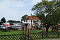
 The Royal Oak, Broad Oak - geograph.org.uk - 699086.jpg 640 × 480; 90 KB


