Category:The Swale
Jump to navigation
Jump to search
English: Colloquially, by long historic tradition, The Swale, is a natural seawater channel in north Kent about 40 miles ESE of London connecting directly to the English Channel along the south end of the Isle of Sheppey and the mouth and bay like estuary of the lower River Medway along it's northern. The swale forms what might be called a second mouth of the River Medway running roughly N-S on the inside of the Isles of Sheppey, England.
channel in the Thames Estuary, United Kingdom  | |||||
| Upload media | |||||
| Instance of | |||||
|---|---|---|---|---|---|
| Location |
| ||||
 | |||||
Subcategories
This category has the following 4 subcategories, out of 4 total.
O
- Oare Marshes (15 F)
S
- Seasalter Levels (3 F)
- South Bank of the Swale (7 F)
- South Swale (3 F)
Media in category "The Swale"
The following 9 files are in this category, out of 9 total.
-
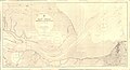 Admiralty Chart No 2571 East Swale Whitstable to Fowley Island, Published 1918.jpg 20,913 × 11,361; 85.58 MB
-
 Admiralty Chart No 2572 West Swale Fowley Island to Queenborough, Published 1918.jpg 11,214 × 16,292; 65.47 MB
-
 Admiralty Charts No 2571 2572 Swale, Published 1918 (composite).jpg 30,461 × 16,311; 128.19 MB
-

-
 New and Old Railway Bridges - geograph.org.uk - 1275738.jpg 640 × 480; 79 KB
-
 Path on Queenborough Beach.jpg 4,430 × 3,384; 14.51 MB
-
 Seawall beside the Swale - geograph.org.uk - 1221543.jpg 640 × 480; 91 KB
-
 The Swale and The Saxon Shore Way - geograph.org.uk - 474522.jpg 640 × 426; 109 KB
-


.jpg)


