Category:Town hall of Châtenoy (Loiret)
Jump to navigation
Jump to search
| Camera location | | View all coordinates using: OpenStreetMap |
|---|
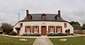
town hall located in Loiret department, France  | |||||
| Upload media | |||||
| Instance of |
| ||||
|---|---|---|---|---|---|
| Location | Châtenoy, Loiret, Centre-Val de Loire, Metropolitan France, France | ||||
| Street address |
| ||||
| Has use | |||||
| Owned by | |||||
| Operator | |||||
 | |||||
Media in category "Town hall of Châtenoy (Loiret)"
The following 8 files are in this category, out of 8 total.
-
 Châtenoy-FR-45-mairie-01.jpg 4,032 × 3,024; 3.26 MB
-
 Châtenoy-FR-45-mairie-02.jpg 4,032 × 3,024; 3.15 MB
-
 Châtenoy-FR-45-mairie-03.jpg 4,032 × 3,024; 3.23 MB
-
 Châtenoy-FR-45-mairie-04.jpg 3,024 × 4,032; 3.26 MB
-
 Châtenoy-FR-45-mairie-05.jpg 4,032 × 3,024; 3.17 MB
-
 Châtenoy-FR-45-mairie-06.jpg 3,024 × 4,032; 3.33 MB
-
 Châtenoy-FR-45-mairie-07.jpg 4,226 × 2,698; 3.07 MB
-
 Châtenoy-FR-45-mairie-08.jpg 3,922 × 2,106; 3.53 MB


