Category:Transport maps of Ohio
Jump to navigation
Jump to search
States of the United States: Alabama · Alaska · Arizona · California · Colorado · Connecticut · Delaware · Florida · Georgia · Illinois · Louisiana · Maryland · Massachusetts · Michigan · Mississippi · Nevada · New Jersey · New York · Ohio · Oregon · Pennsylvania · Texas · Washington – Washington, D.C.
Puerto Rico
Puerto Rico
Subcategories
This category has the following 4 subcategories, out of 4 total.
T
- Trail maps of Ohio (2 F)
Media in category "Transport maps of Ohio"
The following 13 files are in this category, out of 13 total.
-
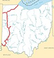
 Cincinnati and Whitewater Canal.jpg 1,242 × 1,330; 316 KB
-
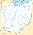
 Hocking Canal map.jpg 1,242 × 1,330; 336 KB
-
 Miami and Erie Canal system map captioned.jpg 1,242 × 1,330; 341 KB
-
 Miami and Erie Canal system map.jpg 1,242 × 1,330; 317 KB
-
 Miami and Erie Canal.jpg 1,242 × 1,330; 324 KB
-
 Pennsylvania and Ohio Canal map.jpg 1,242 × 1,330; 319 KB
-
 Sandy and Beaver Canal map.jpg 1,242 × 1,330; 319 KB
-
 Sidney Feeder Canal.jpg 1,242 × 1,330; 316 KB
-
 Transportation map of Ohio. LOC 77694847.jpg 5,329 × 6,816; 4.14 MB
-
 Transportation map of Ohio. LOC 77694847.tif 5,329 × 6,816; 103.92 MB
-
 Wabash and Erie Canal.jpg 1,242 × 1,330; 318 KB
-
 Walhonding Canal map.jpg 1,242 × 1,330; 316 KB
-
 Warren Canal.jpg 1,242 × 1,330; 316 KB


