Category:Trimdon Foundry
Jump to navigation
Jump to search
civil parish in County Durham, England | |||||
| Upload media | |||||
| Instance of | |||||
|---|---|---|---|---|---|
| Location | County Durham, North East England, England | ||||
 | |||||
Media in category "Trimdon Foundry"
The following 12 files are in this category, out of 12 total.
-
 Barnes West Farm - geograph.org.uk - 1176048.jpg 640 × 451; 74 KB
-
 Farm Track towards Barnes West Farm - geograph.org.uk - 1176059.jpg 640 × 447; 86 KB
-
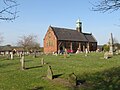 Former church, Trimdon Colliery - geograph.org.uk - 6132809.jpg 1,024 × 768; 196 KB
-
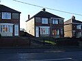 Houses on Wingate Road - geograph.org.uk - 3823106.jpg 640 × 480; 58 KB
-
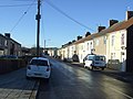 Rodwell Street, Trimdon Colliery - geograph.org.uk - 3823096.jpg 640 × 480; 63 KB
-
 Rodwell Street, Trimdon Station - geograph.org.uk - 6132804.jpg 1,024 × 768; 138 KB
-
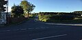 Salter’s Lane - geograph.org.uk - 5557687.jpg 1,024 × 502; 91 KB
-
 Shop on Wingate Road - geograph.org.uk - 3823105.jpg 640 × 480; 57 KB
-
 Shops, Trimdon Station - geograph.org.uk - 3823102.jpg 640 × 480; 67 KB
-
 Thornley Road leaving Deaf Hill - geograph.org.uk - 1176616.jpg 640 × 480; 81 KB
-
 Trimdon Station Methodist Church - geograph.org.uk - 3823103.jpg 640 × 480; 41 KB
-
 Wingate Road - geograph.org.uk - 3823104.jpg 640 × 480; 72 KB


