Category:Turfkade 17, Goes
Jump to navigation
Jump to search
| Object location | | View all coordinates using: OpenStreetMap |
|---|
 | |||||
| Upload media | |||||
| Instance of | |||||
|---|---|---|---|---|---|
| Location | Goes, Zeeland, Netherlands | ||||
| Street address |
| ||||
| Located on street | |||||
| Heritage designation |
| ||||
 | |||||
|
This is a category about rijksmonument number 16386
|
| Address |
|
Media in category "Turfkade 17, Goes"
The following 10 files are in this category, out of 10 total.
-
 Exterieur OVERZICHT VOORGEVELS - Goes - 20299033 - RCE.jpg 1,186 × 1,200; 243 KB
-
 Gevelwand - Goes - 20335884 - RCE.jpg 1,200 × 956; 255 KB
-
 Goes Turfkade 17.jpg 1,712 × 2,288; 746 KB
-
 Overzicht - Goes - 20079870 - RCE.jpg 1,200 × 808; 194 KB
-
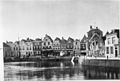 Overzicht - Goes - 20079872 - RCE.jpg 1,200 × 809; 203 KB
-
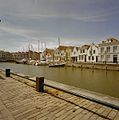
 Overzicht met de Haven op de voorgrond - Goes - 20379824 - RCE.jpg 1,200 × 1,200; 262 KB
-

-
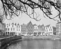 Turfkade, overzicht - Goes - 20079882 - RCE.jpg 1,200 × 960; 315 KB
-
 Voorgevels - Goes - 20079888 - RCE.jpg 818 × 1,200; 183 KB
-
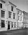 Voorgevels - Goes - 20079889 - RCE.jpg 960 × 1,200; 221 KB


