Category:U.S. Route 57
Jump to navigation
Jump to search
 | number: | (fifty-seven) |
|---|---|---|
| U.S. Routes: | 40 · 41 · 42 · 43 · 44 · 45 · 46 · 48 · 49 · 50 · 51 · 52 · 53 · 54 · 55 · 56 · 57 · 58 · 59 · 60 · 61 · 62 · 63 · 64 · 65 · 66 · 67 · 68 · 69 · 70 · 71 · 72 · 73 · 74 · 75 · 76 · 77 |
U.S. Numbered Highway in Maverick, Zavala, and Frio counties in Texas, United States .jpg)  | |||||
| Upload media | |||||
| Instance of | |||||
|---|---|---|---|---|---|
| Location |
| ||||
| Transport network | |||||
| Owned by | |||||
| Maintained by | |||||
| Inception |
| ||||
| Length |
| ||||
| Terminus | |||||
| |||||
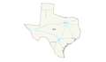
English: Media related to U.S. Route 57, a 98.095-mile (157.869 km) U.S. Numbered Highway in Maverick, Zavala, and Frio counties in Texas, United States, that connects Mexican Federal Highway 57 at the Mexican border with Interstate 35 on the southwestern edge of Moore.
Subcategories
This category has the following 3 subcategories, out of 3 total.
S
- U.S. Route 57 shields (2 F)
Media in category "U.S. Route 57"
The following 3 files are in this category, out of 3 total.
-
 US 57 (TX) map.svg 870 × 516; 531 KB
-
 US 57 map.png 2,205 × 1,286; 32 KB
-
 US57 South sign at Curve (49177157738).jpg 3,600 × 2,400; 2.65 MB
_map.svg)