Category:U.S. Route 91 in Utah (1926-1974)
former routing of a section of U.S. Numbered Highway in Utah, United States   | |||||
| Upload media | |||||
| Instance of | |||||
|---|---|---|---|---|---|
| Location | |||||
| Transport network | |||||
| Owned by |
| ||||
| Maintained by |
| ||||
| Inception |
| ||||
| Dissolved, abolished or demolished date |
| ||||
| Terminus |
| ||||
| Replaced by | |||||
| |||||
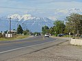
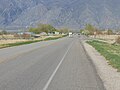
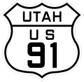
From 1910 to 1962, the former routing of U.S. Route 91 (US 91) in Utah (which at the time extended south to northwest Arizona and closely followed the route of the Arrowhead Trail (auto trail) [and very roughly the current route of Interstate 15]) was officially designated as State Route 1 by the Utah State Legislature. (However, US 91 was not actually designated as such until 1926 with the creation of the United States Numbered Highway System.) In 1962, the State Route 1 designation was applied to Interstate 15. In 1974, the section of US 91 between the Arizona border and Brigham City was removed from the United States Numbered Highway System.
Subcategories
This category has the following 13 subcategories, out of 13 total.
*
A
- Anderson Junction (3 F)
Media in category "U.S. Route 91 in Utah (1926-1974)"
The following 13 files are in this category, out of 13 total.
-
 North at SR-164 & SR-198 junction in Spanish Fork, Utah, May 16.jpg 2,592 × 1,944; 2.37 MB
-
 North at SR-51 & E 800 N Spanish Fork, Apr 16.jpg 2,592 × 1,944; 2.3 MB
-
 North on SR-198 in Spring Lake, Utah, May 16.jpg 2,592 × 1,944; 2.38 MB
-
 North toward SR-115 & SR-156 junction, Apr 16.jpg 2,592 × 1,944; 2.39 MB
-
 Northeast at intersection of SR-51 & Expressway Ln, Apr 16.jpg 2,592 × 1,944; 2.38 MB
-
 Northwest at Anderson Junction Road, Oct 16.jpg 2,592 × 1,944; 2.43 MB
-
 US 91 Utah 1926.svg 1,485 × 1,440; 28 KB
-
 Utah 1.svg 600 × 600; 10 KB
-
 Utah SR 1.svg 385 × 385; 5 KB
-
 West along SR-198 from Salem, Utah, May 16.jpg 2,592 × 1,944; 2.42 MB
-
 West at SR-198 & SR-115 junction, Payson, Utah, May 16.jpg 2,592 × 1,944; 2.35 MB
-
 West on SR-198 from SR-115, Payson, Utah, May 16.jpg 2,592 × 1,944; 2.42 MB
-
 West toward junction of US-89 and SR-75, Feb 16.jpg 2,816 × 2,112; 2.32 MB


